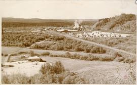
Image depicts the Giscome mill foreman's house on the hill, with Eaglet Lake in the background and numerous piles of logs in the foreground. Map coordinates 54°04'28.0"N 122°22'05.8"W
Image depicts a parking lot full of vehicles with the Giscome store in the background. Map coordinates 54°04'18.5"N 122°21'57.7"W
A Journey into the Upper Peace River Country
Photograph depicts a wide expanse of river in the foreground looking across the water to a narrow clearing along the opposite riverbank. A few building are scattered across the clearing. There is forest in the background.
Photograph depicts people on river shore, and boat and buildings in midground. River bank in foreground, forest in background. Handwritten annotation on verso of photograph: "Giscombe Portage Fraser River", on recto: "Huble & Seaback on Fraser River."
Photograph depicts people and tree stumps in grass areas. Buildings stand on higher level in midground, forest in background. Handwritten annotation on verso of photograph: "Giscombe Portage. B.C.", on recto: "Seaback & Huble"
Image depicts what is possibly the quarry located at Eaglet Lake in Giscome, B.C.
File consists of notes and reproductions relating to Kent Sedgwick's research on Giscome. Includes: "Joe Rositano" typed transcript of an oral interview with Joe Rositano conducted by Dan Watt (14 Apr. 2000). Also includes photographs depicting various buildings in Giscome (2009), and a CD containing photographs depicting the Giscome town plans (2009).
Image depicts the mill site at Giscome, B.C. Map coordinates 54°04'19.7"N 122°22'04.7"W
Image depicts the mill site at Giscome, B.C. A sign in the foreground reads "Maynard's Industrial Auctioneers." Map coordinates 54°04'19.7"N 122°22'04.7"W
Image depicts the mill site at Giscome, B.C. Map coordinates 54°04'19.7"N 122°22'04.7"W
Image depicts the Giscome, B.C. mill site looking west. Map coordinates 54°04'18.5"N 122°21'57.7"W
Image depicts the mill site at Giscome and its beehive burner. Map coordinates 54°04'19.7"N 122°22'04.7"W
Image depicts a food stand at the mill site at Giscome, B.C. Map coordinates 54°04'19.7"N 122°22'04.7"W
Closeup of Giscome School. Handwritten annotation in pen on verso reads: “Our school. This is my 0 room – the back of it.”
Image depicts the Giscome mill site in Giscome, B.C. The bunkhouse is no longer there and the school is in the foreground on the right. Map coordinates 54°04'04.8"N 122°22'04.7"W
Image depicts the Giscome mill site in Giscome, B.C. The bunkhouse is in the background on the left and the school is in the foreground on the right. Map coordinates 54°04'04.8"N 122°22'04.7"W
Street view featuring a dirt road leading directly to Giscome School, a three room institution. On the right the steeple of the Catholic church is visible, beside which was Neff’s (sp?) corner store. Handwritten annotation in pen on verso reads: “Looking up our street. The school is at the end.”
Side perspective of wooden swings covered in snow. Handwritten annotation in pen on verso reads: “The school swings.”
Image depicts the old Giscome Train Station in Giscome, B.C. It was demolished between 1976 and 1977.
Image depicts a street in Giscome B.C. The Giscome Store is located on the left side of the image with the church in the background. Map coordinates 54°04'18.5"N 122°21'57.7"W
This photograph collection consists of 53 photographs featuring primarily Giscome with a few of Prince George. Subjects include the Eagle Lake Sawmill, Eagle Lake, Giscome townsite (including specific buildings and general road perspectives), Giscome School, Division II class photos (1950-51), and the Giscome School teacherage.
File consists of slides depicting Giscome, Smithers, Purden Lake Provincial Lake, and LTSP (long term soil productivity).
Full on photograph of a totem pole in a fenced area. Printed annotation on recto reads: "Indian Totem Poles, Kitwanga, B.C."
Photograph depicts 8 men posing in suits and ties, and a young girl, Ruth Adams, holding trophy seated in foreground. The group is gathered in open field, large building and hills visible in distance. Man on far right stands in uniform.
Handwritten annotation on verso reads: "Gitlakdamix Village Council 1923. [Charlie Morven] Chairman. / Geo. Manase. / John Davis. / Dennis Woods. / Andrew Nass. / James Adams. Secretary. / Frank Blackwing. Chief Constable. / Walter McMillan (Nass). Constable."
Image depicts the Gitwinksihlkw Elementary School in Gitwinksihlkw, B.C.
Ground level photograph of a forested slope, with large glaciers visible in the background. Printed annotation on recto reads: "Glacier Near Stewart B.C. Hughes #75 [or 15??]"
Photograph is a printed postcard depicting a glacier and mountain top near Stewart B.C.
Photograph depicts glacier and snow in mountains. Handwritten annotation on verso of photograph reads: "Glacier, Moose River. B.C."
Postcard depicts Glacier House and Great Glacier.
Postcard depicts Glacier House and Great Glacier House built in 1886 as one of three similar hotels, the other two being Mt. Stephen House in Field, and Fraser Canyon Hotel in North Bend. Business fell off rapidly in 1916 when tracks were relocated into a new tunnel. Buildings were demolished in 1930.
Postcard depicts Glacier House, CPR, and Hermirt Range, Selkirk Mountains.
Photograph of a large glacier with several buildings at its foot. Printed annotation on recto reads: "Hughes #76 Glacier Near Stewart BC."
Photograph of a large glacier. Printed annotation on recto reads: Glacier Near Stewart B.C. Hughes #75."
Photograph depicts glacier on McDame Creek road, 1.5 miles from the mine at Cassiar. Snow-covered trees in background.
Photograph depicts McDame Creek Road, snow-covered and taken from center of road 1.5 miles from the early construction camp at Cassiar. Two stakes in foreground, one on either side of road. Glacier is believed to be crossing road between two stakes. Trees on either side of road, trees and hills in background.
Postcard depicts Glacier Station.
Photograph depicts mountain tops and snowy glaciers.
File consists of slides depicting the UNBC parking lot, the Domano/Gladstone intersection in Prince George, the Bill Reid banners in the UNBC administration building, a car fire, and UNBC faculty and staff.
The three women stand in the Prince Rupert Masonic Temple looking at baby pictures of Selma Murray.
Handwritten annotation on verso reads: “From Left to Right, Aug/74, Gladys Blyth - Port Ed, Iona Campagnolo - ‘MP Skeena,’ Lil Schuman - Manitoba (‘Mother’ - Aunt) to Selma Murray, Masonic Temple - Pr. Rupert, B.C., Reception for Selma, looking at baby picture of Selma”.
Photograph depicts a Glen Vowell First Nations child watching a solo performance of a boy wearing a button blanket on stage at a potluck.
Photograph depicts Glen Vowell First Nations children performing on stage.
Photograph depicts Glen Vowell First Nations children performing a dance in a semi-circle at a potluck.