Showing 27992 results

Archival description
17269 results with digital objects Show results with digital objects
2005.3.32 · Item · [ca. 1945]
Part of John Hart Highway Photograph Collection

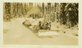
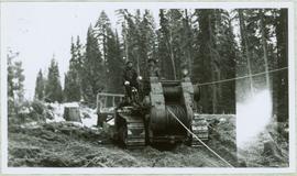
Handwritten caption above this photo reads: "Fred Youngstron[sic?]" "Foreman spotting for operator." Photograph depicts one man (Fred?) seated on D8 Caterpillar operating a haulback rig, and a second man standing beside him on the Caterpillar. Dirt and debris in foreground, forest in background. It is believed this rig is operating in a long-line skidding system.

2013.6.36.1.028.28 · Item · 18 Sept. 1970
Part of David Davies Railway Collection

Photograph depicts a freight shed at the Nelson CPR depot. There is a terminal spur on the south side of the shed and road trucks on the north side. The road side of the main depot building can be seen in the left rear of the photo. The view is facing east.

2013.6.36.1.028.32 · Item · Aug. 1983
Part of David Davies Railway Collection

Photograph depicts a westbound freight train near Moyie on the CPR line. This is at about mile 13 on the Nelson Subdivision, which spans 137.8 miles from Cranbrook to Nelson. The line here is adjacent to the Moyie Lake Provincial Campsite. The train is about to enter the portal of a small tunnel that bores through the rocky headland of the lake.

2013.6.36.1.021.07 · Item · [24 May 1973]
Part of David Davies Railway Collection

Photograph depicts a Princeton bound freight train passing the old CPR station at Brookmere, located at 30 miles south of Merritt. The freight is passing the summit between Spences Bridge and Princeton. It consisted of 4 locomotives and 38 cars (mainly chip cars). At one time Brookmere was a thriving substation divisional point in the middle of nowhere. Now it is a passing loop to hold 64 cars.

2013.6.36.1.021.06 · Item · [24 May 1973]
Part of David Davies Railway Collection

Photograph depicts a southbound freight train passing the old CPR station at Brookmere, located at mile 108.7 on and from the Princeton Subdivision. The freight passed at about 20 mph, after a long grind uphill from Merritt. It consisted of 4 locomotives, 38 cars, and a caboose. Regular freights only pass twice a week, one each on Tuesday and Thursday. It is passing the derelict water tank at the north end of the yards, which are at the summit of this subdivision.

2012.13.4.29 · File · 2001-2006
Part of J. Kent Sedgwick fonds

File consists of notes and reproductions relating to the local history project done by June Chamberland and her book "From Broadaxe to Clay Chinking: Stories about the Pioneers in and around the Prince George area" winning the Jeanne Clarke history award. The book includes a chapter "Introduction to Early Agricultural Settlement in the Prince George Area" by Kent Sedgwick. Includes a CD titled "June photos" containing photographs depicting interviewees of the project (2003).

From Cutbanks
2012.13.1.3.005 · Item · Apr. 1972
Part of J. Kent Sedgwick fonds

Image depicts the Fraser River from the vantage point of the cutbanks in Prince George, B.C.

From Raven Peak
2012.13.1.79.05 · Item · June 1977
Part of J. Kent Sedgwick fonds

Image depicts a view of the Sugarbowl Grizzly Den Protected Area from Raven Peak. The slide itself is labelled "towards cabin."

From Summit Lake
2014.10.1.121 · Item · 1910
Part of Arthur Holland Land Surveying Collection

Photograph depicts two men preparing to load a canoe on a wagon. Two blanketed horses stand nearby with one person attending. There is a lake in the background, wild grasses and brush in the foreground.

Front Street, Quesnel, BC
2011.3.1.17 · Item · ca. 1930
Part of North Coast & Central BC Postcard Collection

Street view photograph taken at the intersection of Front Street and Carson Avenue. Several men are gathered at Cowan's Hardware store on the corner. Also visible in this photograph is the Cariboo Hotel (visible furthest to the left), and the British American Hotel which is partially visible behind the J.A. Fraser store. Printed annotation on recto reads: "On Front Street, Quesnel, B.C."

Fruit Trees
2009.5.2.174 · Item · [ca. 1935?]
Part of Taylor-Baxter Family Photograph Collection

Photograph depicts young fruit trees planted in fenced area with small wind mill, hills in background. Handwritten annotation on recto of photograph: "This is part of the fruit trees if you place it along side of the other one you can see the location the farm buildings are on the other side I didn't get one of them."

FSTY 205 / FSTY 425 in 1996
2016.7.3.14 · File · Oct. 1996
Part of Dr. Joselito Arocena fonds

File consists of slides depicting FSTY 205 students, Tyner Boulevard, Forests for the World, Chilcotin River, FSTY 425 students, Aleza Lake, soil profiles, and luvisol.

FSTY 205 and FSTY 404
2016.7.3.33 · File · Nov. 1999
Part of Dr. Joselito Arocena fonds

File consists of slides depicting Bear Lake, FSTY 205 students, FSTY 404 students, a forestry field camp, Aleza Lake, Paul Sanborn, and UNBC campus.

FSTY 205 images
2016.7.3.02 · File · [18 June 1995]
Part of Dr. Joselito Arocena fonds

File consists of slides noted by Arocena as relating to his FSTY 205 course. People and places depicted include: UNBC Forestry faculty, Aleza Lake, Klinka, Tabor Creek, Lake Babine, Bell Mine site, Smithers, Kitwanga, Alaska Highway, Bear Glacier, Muncho Lake, Mt. Robson, and UNBC Campus.

FSTY 205 in 1996
2016.7.3.09 · File · 28 Feb. 1996
Part of Dr. Joselito Arocena fonds

File consists of slides depicting a sunset, FSTY 205 students, McGregor Model Forest, and possibly a flare pit.

FSTY 205 in September 1998
2016.7.3.27 · File · Sept. 1998
Part of Dr. Joselito Arocena fonds

File consists of slides depicting FSTY 205 students, the Prince George Organic Rehabilitation Program, Chris Opio, Linette Keller, and Clear Lake.