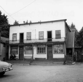
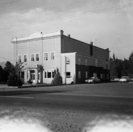
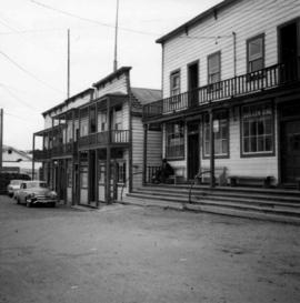
Showing 4353 results

Archival description
3212 results with digital objects Show results with digital objects
Church
2012.13.1.6.098 · Item · Aug. 1979
Part of J. Kent Sedgwick fonds

Image depicts a church, somewhere between Hazelton and Hagwilget, B.C.

2009.5.3.29 · Item · [ca. 1912]
Part of Taylor-Baxter Family Photograph Collection

Photograph depicts two men standing in street at the Fort George Reserve. A church with steeple stands in midground, on left side of street. Forest in background. Handwritten annotation on verso and recto of this photograph reads: "Fort George Temple." See item 2009.5.3.28 for photograph depicting this reserve which belonged to the Lheidli T'enneh Band.

2013.6.36.1.074.08 · Item · [July 1966]
Part of David Davies Railway Collection

Photograph depicts a church that was built of shaped logs on the territory of the Tsal'alh Nation on the road leading to Seton Lake. Church was derelict, but still held pews, plastic flowers and small shrines.

Chute depot on the CPR line
2013.6.36.1.024.11 · Item · [24 June 1979]
Part of David Davies Railway Collection

Photograph depicts the Chute depot at mile 106.5 on the CPR line in the Carmi Subdivision. It is a totally isolated location, but not reachable by road. The photo shows the only surviving large building. The rail here is dated 1942.

"City Hall"
2012.13.3.1.15.02 · Item · Aug. 2002
Part of J. Kent Sedgwick fonds

The item is a photograph of a photograph depicting Prince George's City Hall circa. 1922 including an approximately 120 word write up describing its history. The building is approximately two stories high. There is an artillery cannon next to the building. A reflection of the photographer is barely visible in the photograph.

"City Hall"
2012.13.3.1.15.03 · Item · Aug. 2002
Part of J. Kent Sedgwick fonds

The item is a photograph of a photograph depicting Prince George's City Hall circa. 1922 including an approximately 120 word write up describing its history. The building is approximately two stories high. There is an artillery cannon next to the building. A reflection of the photographer is barely visible in the photograph.

"City Hall"
2012.13.3.1.15.04 · Item · Aug. 2002
Part of J. Kent Sedgwick fonds

The item is a photograph of a photograph depicting Prince George's City Hall circa. 1922 including an approximately 120 word write up describing its history. The building is approximately two stories high. There is an artillery cannon next to the building. A reflection of the photographer is barely visible in the photograph.

City Hall
2012.13.1.3.165 · Item · May 2001
Part of J. Kent Sedgwick fonds

Image depicts Prince George City Hall. Map coordinates 53°54'46.3"N 122°44'41.9"W

"City Hall"
2012.13.3.1.15.07 · Item · Aug. 2002
Part of J. Kent Sedgwick fonds

The item is a photograph of a photograph depicting Prince George's City Hall circa. 1922 including an approximately 120 word write up describing its history. The building is approximately two stories high. There is an artillery cannon next to the building. A reflection of the photographer is barely visible in the photograph.

"City Hall"
2012.13.3.1.15.05 · Item · Aug. 2002
Part of J. Kent Sedgwick fonds

The item is a photograph of a photograph depicting Prince George's City Hall circa. 1922 including an approximately 120 word write up describing its history. The building is approximately two stories high. There is an artillery cannon next to the building. A reflection of the photographer is barely visible in the photograph.

"City Hall"
2012.13.3.1.15.06 · Item · Aug. 2002
Part of J. Kent Sedgwick fonds

The item is a photograph of a photograph depicting Prince George's City Hall circa. 1922 including an approximately 120 word write up describing its history. The building is approximately two stories high. There is an artillery cannon next to the building. A reflection of the photographer is barely visible in the photograph.

2012.13.3.1.16.1 · Item · Jan. 1998
Part of J. Kent Sedgwick fonds

The item is a photograph depicting the Prince George Coliseum from the outside. It shows a full parkin lot, a bus dropping people off and a layer of snow on the ground. The Civic Centre can be seen in the background. The annotation on the back states, "Coliseum Jan. 98."

Clinton Creek Construction
2000.1.1.2.08 · File · 1966 - 1967
Part of Cassiar Asbestos Corporation Ltd. fonds

Cassiar Asbestos Corporation Ltd opened a second mine in 1967 at what became the one-industry town of Clinton Creek, Y.T. File contains photographs depicting progressive construction of buildings at the Clinton Creek mine, plant, townsite and powerhouse. Mine photos depict the crusher site and tramline station. Plant photos depict the dryer, fibre storage, mill, service, vault, and office buildings, as well as the dry rock storage tunnel, reclaim tunnel, and loading dock. Construction living quarters are depicted as well as the construction of residences at the townsite. The power house was built south of the town and plant, on the shore of the 40 Mile River. Some annotations describe the type of material being used for construction.

Clinton Creek Operations
2000.1.1.3.20 · File · 1961 - [ca.1975]
Part of Cassiar Asbestos Corporation Ltd. fonds

Cassiar Asbestos Corporation Ltd opened a second mine in 1967 at what became the one-industry town of Clinton Creek, Y.T. File contains photographs depicting different areas of operations at Clinton Creek. Locations include the mine, plant, town, tailings pile, main office, the 40 Mile River, and surrounding area. Town photos depict the grocery store, cafeteria, medical clinic, school, auditorium residential area, Connell Street and power house. File also includes aerial photographs and images depicting forest fighting, photographers capturing the tailings pile, asbestos samples, mining machinery, staff offices, and operations in the mill, lab, and garage.

Additional photographs integrated into file depict Clinton Creek's surrounding area, and three slides of a tailing pile explosion believed to be Clinton Creek.

2009.7.1.036 · Item · [between 1874 and 1901]
Part of Archdeacon W. H. Collison fonds

Large church stands behind white fence, unidentified man visible on front steps. Photograph depicts the first church built in Metlakatla, which was burned in a fire in 1901, and replaced in 1903.

Handwritten annotation on verso reads: "With love, from your two old friends JH [& AM Keen?]".