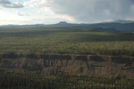
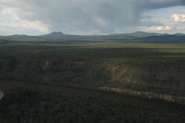
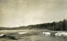
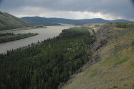
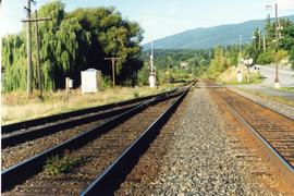
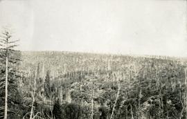
Image depicts Eaglet Lake, north-east of Prince George, B.C.
Image depicts the site of Giscome's first quarry, with Eaglet Lake located in the foreground.
Image depicts the site of Giscome's first quarry, with a train passing by and Eaglet Lake located in the foreground.
Image depicts an eastern view over Eaglet Lake.
Image depicts the creek flowing into Eaglet Lake. A grey area of hill on the right side of the image appears to be the Giscome Quarry. Map coordinates 54°04'26.2"N 122°22'04.3"W
Image depicts Eaglet Lake in the winter taken from Giscome, B.C. Map coordinates 54°04'20.9"N 122°21'53.1"W
Photograph depicts Earle Birney at the College of New Caledonia.
Photograph depicts the caboose office: a small wooden structure with flat roof and one door. Snow pathways and power pole in foreground, trees and hills in background.
A collection of photographs from the site that Cassiar was being built in the early 50s. Photos depict lumber piles, early camp area, the first buildings, mountains, and the creek.
Along with this collection there are a set of images also from the early Cassiar site mainly depicting a dirt road and various individuals and machinery along it.
Photograph depicts cookery building with truck on right, in front of door. Snow-covered lumber piles and machinery in foreground, trees and mountain in background.
Photograph depicts cookery and bunkhouse buildings from side angle. Three trucks in foreground, unidentified object on right, trees and mountains in background.
Photograph of several commercial and residential buildings, including the church and "The Big Furniture Store." Annotation on recto reads: "Prince Rupert. BC Allen Photo July '11." Handwritten annotation on verso reads: "Early day- Prince Rupert."
File consists of:
- Press release and order form: "Tillacum Library announces the publication of Stoney Creek Woman: The Story of Mary John" (Winter 1989)
- Book launch invitation: "Tillacum / Pulp Press invite you to a book launching for Stoney Creek Woman by Bridget Moran
- Letter to Bridget Moran from Linda [Field], Tillacum Library (a division of Arsenal Pulp Press Book Publishers) re: formatting and editing of Stoney Creek Woman (June 21, 1988)
- News release for Stoney Creek Woman: The Story of Mary John by Bridget Moran
- Handwritten note featuring "Stoney Creek Woman" in the Carrier language
- Letter to Bridget Moran from John Matters re: Stoney Creek Woman (Jan. 25, 1989)
- Letter of acceptance to Bridget Moran from Linda Field re: publication of Stoney Creek Woman by Tillicum Library (May 26, 1988)
- Newspaper clipping re: news release of Stoney Creek Woman
- "A step or two in her moccasins" by Bridget Moran; a synopsis of Stoney Creek Woman; a Prologue of Stoney Creek Woman*"Pictures" - photograph key
- Book signing newspaper advertisement: "Bridget Moran & Mary John will once again be at Mosquito Books to autograph copies of Stoney Creek Woman"
- Publishers press release for Stoney Creek Woman: The Story of Mary John (Winter 1989)
- Memorandum sent to The Bulletin re: Bridget Moran's newly published book Stoney Creek Woman. (May 24, 1989)
- Handwritten note sent by Mary Ann [Lyall] to Bridget (?) re: strategic gifting of copies of Stoney Creek Woman
- Handwritten note sent to Oscar Bedard, Executive Director, Program Development, Ministry of Education from Bridget Moran re: Stoney Creek Woman (Jan. 4, 1989)
- Photographs: Elders' gathering, 1983, Mary John stretching a hide, Mary John in a flower print dress, standing in a field, Lazare in a kitchen serving ice cream to a little boy.
Photographic negative depicts a map titled "Early Days in Stewart".
Photograph depicts a donkey engine at the Cowichan Valley Forest Museum
A collection of photographs of the early exploration exhibitions in the asbestos mountains area.
Photograph depicts an early internal combustion tractor at Greenwood, BC
Early spring landscape with roadbed and track in foreground, river in midground, and hill in background.
Handwritten annotation on recto: “PRINCE GEORGE 4-20-13”.
Photograph of early model airplane displaying logo: “Air Service U.S.A. World Flight”. Printed annotation on recto reads: “Amercian Aviators on World Trip arriving at Prince Rupert. BC April 6th, 24 McRae” Handwritten annotation on verso in pencil reads: “Air Service USA World Flight”
Photograph depicts an early motor car/truck wheel found beside a private garage.
Photograph depicts the North peak of McDame mountain in the earlier stages of strip mining, South peak unmined in background. Quonset and other shops visible in left foreground, unknown building built into mountainside in right foreground.
Photograph depicts wood houses behind stand of trees in Cassiar valley. Truck, power poles, and road in foreground, mountains in background. Typed caption below photo in original duotang album: "Two Bedroom Pan-Abode Houses - Cassiar Townsite". Handwritten annotation on verso: "Sept 1954".
Photo of the Prince Rupert harbour. Many buildings are visible along the shoreline. Annotation on recto reads: "Harbour, Prince Rupert, BC. 1658."
Photo of the Prince Rupert harbour. Many buildings are visible along the shoreline. Annotation on recto reads: "Harbour, Prince Rupert BC. 1658." Handwritten annotation on verso reads: "Early Prince Rupert. Good view of Metlakatla Passage in distance- showery[?] Wolf Island."
Photograph depicts an early type of spool donkey circa 1890-1900, on display at Promised Land Park on the Olympia Peninsula in Washington state.
Photograph depicts open river waters with some patches of ice on the river shore. There are riverbanks and trees in the background.
Photograph depicts an early type of steam donkey mounted on a flatcar and attached to a Shay Tank. It is displayed on the roadside at Promised Land Park, probably near Forks, on the Olympic Peninsula in Washington state.
Hills on opposite shore in background.
Handwritten annotation on verso reads: "Early steamship off mouth of Nass River".
Row of buildings with path and poles. Rough cleared land in foreground, men visible in far left background.
Photograph depicts an early type of tractor manufactured by Titan Engine Manufacturing, Chicago. Made for and sold by Int. Harvester Co. Hamilton, Ontario.
Photograph depicts a derelict early type of gas station on the south outskirts of Nanaimo on the old coast road.
Photograph depicts an early type of truck that was on display during a May Day Parade. It was owned by a service station operator on the Island Highway.
Image depicts an earth flow north of Stone Creek, B.C.
The item is a photograph slide reproduction depicting houses in flood waters on the east end of Prince George. Annotation states, "1936 east end."
Photograph depicts the resurfacing of several blocks of East Georgia Street that caused old streetcar lines to be pulled up.
Subseries consists of material collected by Kent Sedgwick for research regarding the communities along the East Line of the Grand Trunk Pacific Railway in Central British Columbia, particularly between Prince George and McBride. These communities and locations include, among others, Shelley, Willow River, Sinclair Mills, Longworth, Dunster, Tete Jaune, Valemount, Mount Robson, and the Yellowhead Pass. Research on these communities was conducted during Kent Sedgwick's involvement in the UNBC-led Upper Fraser Historical Geography Project. The files primarily consist of research notes, audio and transcripts of oral interviews, and photographs of the East Line communities.
File contains slides depicting places along the east line of the BC Railway. Some are duplicates of the images found in the "East Line, Dome Creek - Lamming Mills - Misc" file.
File contains slides depicting places along the east line of the BC Railway.
File consists of notes and printed photographs relating to the East Line. The file includes photographs that depict various areas on the Upper Fraser and within the communities, including Dome Creek; Sinclair Mills; Penny; Grand Canyon; and Crescent Spur (between 1999 and 2005).
File contains slides depicting places along the east line of the BC Railway.
Photograph taken looking east from the Salmon Arm depot which still stood (as stores and offices) on its original site.
Photograph depicts a view from a high ridge looking over vast forest.
Photograph depicts East Pender St., looking west towards the Vancouver Sun newspaper office near Abbot St. in Vancouver, B.C.
Postcard depicts the east portal of the Connaught Tunnel and Mount Macdonald.