Showing 1023 results

Archival description
815 results with digital objects Show results with digital objects
P.G. Then and Now
2012.13.1.007 · Subseries · [between 1975 and 2003]
Part of J. Kent Sedgwick fonds

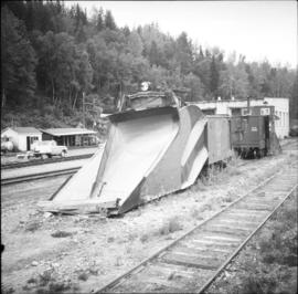
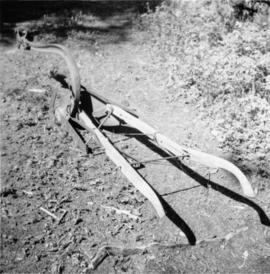
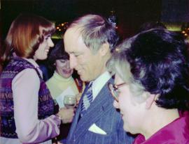
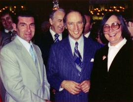
File contains slides depicting images of Prince George ranging from 1975 to 2003.

PGE Grade
2012.13.1.041 · Subseries · [between 1980 and 2003]
Part of J. Kent Sedgwick fonds

File contains slides depicting the grade for what was formerly the Pacific Great Eastern, and is now known as British Columbia Railway.

PGE Grade - View South
2012.13.1.41.03 · Item · 2001
Part of J. Kent Sedgwick fonds

Image depicts a view of the south direction of the grade for the British Columbia Railway, which was formerly known as the Pacific Great Eastern until 1972. It is at an uncertain location, possibly near Woodpecker or Prince George.

Photographs
2000.13.1 · Series · 1914 - 1997
Part of Ray Williston fonds

Series consists of photographs relating to Ray Williston's life from childhood to recent times, air photographs of Prince George, photographs of Bangladesh, and a listing of photographs slated for use in Mr. Williston's biography "Forests, power and policy: the legacy of Ray Williston" written by Eileen Williston and Betty Keller.

Pine Centre Mall
2012.13.1.3.111 · Item · 12 Oct. 1989
Part of J. Kent Sedgwick fonds

Image depicts Pine Centre Mall in Prince George, B. C. Map coordinates 53°53'53.2"N 122°46'36.4"W

Pineview
2012.13.1.3.144 · Item · [199-?]
Part of J. Kent Sedgwick fonds

Image depicts Pineview on Buckhorn Lake Road, Prince George, B.C.

Pineview
2012.13.1.3.145 · Item · [199-?]
Part of J. Kent Sedgwick fonds

Image depicts Pineview on Buckhorn Lake Road, Prince George, B.C.

Pineview
2012.13.1.3.146 · Item · [199-?]
Part of J. Kent Sedgwick fonds

Image depicts Pineview on Buckhorn Lake Road, Prince George, B.C.

Powerline
2012.13.1.3.037 · Item · Nov. 1977
Part of J. Kent Sedgwick fonds

Image depicts power lines east of the pulp mills in Prince George, B.C.

Prince George
2012.13.1.3.046 · Item · Jan. 1978
Part of J. Kent Sedgwick fonds

Image depicts a view of Prince George from City Hall looking northeast along George Street. Map coordinates 53°54'46.3"N 122°44'41.9"W

Prince George
2012.13.1.3.077 · Item · May 1984
Part of J. Kent Sedgwick fonds

Image depicts downtown Prince George looking northwest. Map coordinates 53°54'48.7"N 122°44'45.6"W

Prince George
2012.13.1.3.078 · Item · May 1984
Part of J. Kent Sedgwick fonds

Image depicts a view of Prince George from City Hall looking northeast along George Street. Map coordinates 53°54'46.3"N 122°44'41.9"W

Prince George
2012.13.1.3.135 · Item · 12 Oct. 1989
Part of J. Kent Sedgwick fonds

Image depicts Prince George, possibly with the Northwood Pulpmill in the background.

Prince George
2012.13.1.3.133 · Item · 12 Oct. 1989
Part of J. Kent Sedgwick fonds

Image depicts Prince George, possibly with the Northwood Pulpmill in the background.

Prince George
2012.13.1.3.169 · Item · Mar. 2003
Part of J. Kent Sedgwick fonds

Image depicts an aerial view of what is possibly an outlying area of Prince George, B.C.

Prince George
2012.13.1.3.042 · Item · Nov. 1977
Part of J. Kent Sedgwick fonds

Image depicts downtown Prince George looking northwest across Dominion Street. Map coordinates 53°54'48.7"N 122°44'45.6"W

Prince George
2012.13.1.3.134 · Item · 12 Oct. 1989
Part of J. Kent Sedgwick fonds

Image depicts Prince George, possibly with the Northwood Pulpmill in the background.