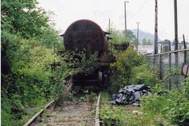
Image depicts the Duchess engine, which was built in 1878 and taken out of service in 1919. It was part of a matched set with the Duke and is now a tourist attraction in Carcross, Y.T.
Group of men stand on pier by warehouse, looking out at the boat. Treed mountains visible in background.
Handwritten photo caption beside image reads: "Danube".
Slightly elevated front-facing photograph of a steam engine and cargo coming into a station in Prince Rupert, BC. Coal and lumber yards are visible in the background. Annotation on recto reads: "The C.N.R. Prince Rupert. 79."
Postcard depicts "Canadian Pacific's eastbound, "The Canadian," crosing the Kicking Horse River between Golden and Field B.C. in October 1976. Some of the... trains power through some of North America's most spectacular scenery. The morning has brought the season's first snowfall."
Postcard depicts "Canadian Pacific's all Stainless Stel Scenic Dome Streamliner-"The Canadian"-in the Canadian Rockies."
Postcard depicts "VIA Rail Canada Nos. 6456 and 6454 hauling Train No. 1, "The Canadian" between Spences Bridge and Drynoch, British Columbia, on Canadian Pacific's Thompson Subdivision, having been delayed by the need to detour, from its usual route, on Canadian National's Ashcroft Subdivision, seen here across the Thompson River. May 14, 1993."
Photograph depicts the bow of a weather ship swamped with water after waves broke over the side of the ship.
Photograph depicts the bow end of a ship getting swamped by a wave in rough water.
Photograph depicts the bow of a weather ship with a large body of water in the background.
This photograph album consists of photographs of remote police barracks at Mile 47 and Mile 29; early settlements and/or mercantile stores at Tete Jaune Cache, McBride, Sand Creek, Fort George and South Fort George; Grand Trunk Pacific Railway forestry and railway camps; scows and paddlewheel conveyors on the Fraser River; automobiles; community leisure activities; as well as, images of the Bourchier family. The following South Fort George establishments are identifiable within these photographs: Empress Hotel, Ah Yee General Merchant, German Bakery, Northern Hotel, South Fort George Drug Store & Post Office, St. Michael’s Church, Prince George Hotel, Ford Monarch dealership, Astoria Hotel, and King George V Elementary School. Identified geographic locations featured in these photographs include: Tete Jaune, Upper Fraser, Mile 47, Mile 29, Fraser River, Mt. Robson, McBride, Sand Creek, Glacier Mountain, Moose River, Giscome Portage, Pott Falls, Red Deer River, Grand Canyon, Summit Lake, Canoe Pass, Connaught Hill, Nechako Bridge, and Island Cache.
Bourchier, Alan K.Stern wheeler passing through rapids. Printed annotation on recto reads: “The B.C. Express passing through the Grand Canyon B.C.” Handwritten annotation in red ink on recto adds: “1913”
Handwritten annotation in pen on verso reads: "Dad [W.E. Collison] on ‘Naskeena’ – Prince Rupert Harboue en route to Nass River”.
Indian agency boat the “Naskeena” en route to its next destination. Handwritten annotation in pen on verso reads: “ ‘Naskeena’ en route”
Indian agency boat the “Naskeena” off Kitkatla B.C. W.E. Collison, Indian Agent standing at the stern.
Handwritten annotation in pen on verso reads: “‘Naskeena’ Gov. patrol boat off Kitkatla BC. W.E. Collison on stern.”
Image depicts a vehicle on a gravel road somewhere near Tête Jaune Cache, B.C.
Handwritten photo album caption below this photo reads: "Teslin Lake and River, at 11 000 feet." Photograph depicts winding river below, mountain range in background.
Royal Canadian Air ForceImage depicts a rail road bridge located somewhere near Terrace, B.C.
Photo description on accompanying photo album page: " 'Yonge Street' at Teslin Lake, Yukon. The centre tent was used by the radio men. Teslin, 130 miles south of Whitehorse, is the site of one of the aircraft radio stations on the new Edmonton-Whitehorse circuit, paralleling the Alaska Highway."
Photograph depicts ten ballast cars of the B.C. Electric Railway on newly laid industrial spur on the northeast side of the Langley depot.
Image depicts two bridges in Telkwa, B.C. One is for trains.
Photograph depicts telephone fittings on Vancouver Island.
Image depicts a set of railway tracks, and a building with a sign which reads: "Telegraphs." The location is uncertain, but possibly in the Peace River Region.
Group of men, women, and children stand in field below large sign that reads: "GRAND TRUNK PACIFIC TRACK CONNECTED APRIL 7th 1914 PRINCE RUPERT MILEAGE 373-96 - WINNIPEG MILEAGE 1,374". Two men in formal attire stand on either side of group, women and children in between. A spotted dog stands on right. It is believed that members of the Taylor family are present in group (Hermina holding infant Tom, surrounded by Violet, Lucy, Arthur, Virginia, and Dixon). Man and woman in back left speculated to be Lillian and A.K. Bourchier. Handwritten annotation on envelope of negative reads: "Ft. Fraser 1916".
Photograph depicts a tank 'Scale Test Car' at the Kamloops CPR yard.
Photograph depicts a tank that was found outside of the headquarters of the British Columbia Armoured Regiment in Vancouver.
Photograph depicts a new tank car for sodium chlorate CN/CP interchange.
Photograph depicts an old tank car owned by a logging railway on Vancouver Island, parked at the end of a spur behind a locomotive shed of the Alberni Pacific Railway.
Snow on either side of highway stands at extreme height.
Image is one of 65 photos documenting a survey of the Canada-Alaska Boundary, Taku River area, May 23 to Oct. 15, 1906.
This particular photo is one of 13 found in original enclosure with the following handwritten annotation: "SOME OTHERS." See also items 2006.20.3.22 - 2006.20.3.34.
Photograph depicts two unknown men walking on rocky shore with canoe over their heads. Water and forest in background. Handwritten annotation visible on negative: "[?] portaging canoe".
Image is one of 65 photos documenting a survey of the Canada-Alaska Boundary, Taku River area, May 23 to Oct. 15, 1906.
This particular photo is one of 8 found in original enclosure with the following handwritten annotation: "From main camp up Kopoka River. Scenes with persons in." See also items 2006.20.3.14 - 2006.20.3.21.
Photograph depicts two men paddling in canoe, shore in background. Handwritten annotation visible on negative reads: "Stughes & B_ Lake behind Main Camp Taku River".
Image is one of 65 photos documenting a survey of the Canada-Alaska Boundary, Taku River area, May 23 to Oct. 15, 1906.
This particular photo is one of 13 found in original enclosure with the following handwritten annotation: "SOME OTHERS." See also items 2006.20.3.22 - 2006.20.3.34.
Photograph depicts two men climbing up snowy area with walking poles and other gear. Handwritten annotation visible on negative: "Nellis & Gilroy Snow [?] - No.3."
Image is one of 65 photos documenting a survey of the Canada-Alaska Boundary, Taku River area, May 23 to Oct. 15, 1906.
This particular photo is one of 13 found in original enclosure with the following handwritten annotation: "SOME OTHERS." See also items 2006.20.3.22 - 2006.20.3.33.
Photograph depicts two men standing on mountain with walking sticks, carrying bundles on their backs. Valley and mountains visible in background below. Handwritten annotation visible on negative: "[?] Climbing [?] Sta - K. River" (Kopoka?).
Image is one of 65 photos documenting a survey of the Canada-Alaska Boundary, Taku River area, May 23 to Oct. 15, 1906. This particular photo is one of 7 found in original enclosure with the following handwritten annotation: "Around River Taku and main camp on same." See also items 2006.20.3.35 - 2006.20.3.41.
Photograph depicts unknown men standing with walking sticks, carrying large bundles on their backs. Water and opposite shore in background, mountains visible in distance. Handwritten annotation visible on negative: "Billy [Gilroy?] & [?] packed for [?]".
Image is one of 65 photos documenting a survey of the Canada-Alaska Boundary, Taku River area, May 23 to Oct. 15, 1906.
This particular photo is one of 13 found in original enclosure with the following handwritten annotation: "SOME OTHERS." See also items 2006.20.3.22 - 2006.20.3.34.
Photograph depicts three unknown men standing in water while pulling loaded canoe by rope. Rocky shore and hills in background. Illegible handwritten annotation visible on negative: "...[K. River]?" (Kopoka?)
Image is one of 65 photos documenting a survey of the Canada-Alaska Boundary, Taku River area, May 23 to Oct. 15, 1906.
This particular photo is one of 8 found in original enclosure with the following handwritten annotation: "From main camp up Kopoka River. Scenes with persons in." See also items 2006.20.3.14 - 2006.20.3.20.
Photograph depicts two unidentified men on small boat with sail, opposite shore in background. Handwritten annotation on negative: "Prospectors on Taku Sailing".
Image is one of 65 photos documenting a survey of the Canada-Alaska Boundary, Taku River area, May 23 to Oct. 15, 1906.
This particular photo is one of 13 found in original enclosure with the following handwritten annotation: "Kopoka River - river scenes Aug 29 to Oct. 9 [19]06". See also items 2006.20.3.1 - 2006.20.3.13.
Photograph depicts three unidentified men loading canoe on river shore.
Image is one of 65 photos documenting a survey of the Canada-Alaska Boundary, Taku River area, May 23 to Oct. 15, 1906.
This particular photo is one of 8 found in original enclosure with the following handwritten annotation: "From main camp up Kopoka River. Scenes with persons in." See also items 2006.20.3.14 - 2006.20.3.21.
Photograph depicts unknown man in canoe, opposite shore and hills in background.
Image is one of 65 photos documenting a survey of the Canada-Alaska Boundary, Taku River area, May 23 to Oct. 15, 1906.
This particular photo is one of 8 found in original enclosure with the following handwritten annotation: "From main camp up Kopoka River. Scenes with persons in." See also items 2006.20.3.14 - 2006.20.3.21.
Photograph depicts unknown man standing in water while pulling loaded canoe by rope. Rocky shore in foreground, mountains in background. Handwritten annotation visible on negative: "[?] hauling canoe. Big [?], Kopoka".
Image is one of 65 photos documenting a survey of the Canada-Alaska Boundary, Taku River area, May 23 to Oct. 15, 1906.
This particular photo is one of 8 found in original enclosure with the following handwritten annotation: "From main camp up Kopoka River. Scenes with persons in." See also items 2006.20.3.14 - 2006.20.3.21.
Mountains stand behind water in background. Handwritten annotation on negative: "looking [over?] Kopoka".
Image is one of 65 photos documenting a survey of the Canada-Alaska Boundary, Taku River area, May 23 to Oct. 15, 1906.
This particular photo is one of 13 found in original enclosure with the following handwritten annotation: "Kopoka River - river scenes Aug 29 to Oct. 9 [19]06". See also items 2006.20.3.1 - 2006.20.3.13.
Photograph depicts the Cassiar plantsite behind tailings pile in foreground. Mine road runs north though valley bellow mine, strip mining barely visible in background. Photograph was taken from above, facing north.
Photograph depicts a switching locomotive and stand-in locomotive.
Photograph depicts switcher #8106 and caboose #434612 that just arrived with a loaded train from a pulp mill. To the left lay the main track to Nelson.
Photograph depicts switcher #8106 that served the 3 mile branch to a pulp mill. The switcher pulled with heavy string of loaded cars from the mill. The trip was a caboose run. Locomotive built in 1958 as part of a batch of 31. 17 of them remained in 1997.
Photograph depicts the swing span of the road and rail bridge at Mission City, looking upstream from the south bank.
Photograph depicts the CPR swing bridge crossing the Harrison River at Harrison Mills. It is a plate girder bridge carrying a double track. The bridge tender occupied a shanty at the east end of the bridge at mile 68.3 from North Bend. The timetable states that trains may proceed at restricted speed after stopping, if the tender fails to appear after 4 whistle signals and the hone signals show stop.
Photograph depicts a man seated on cab floor of dragline crane with " CAMPBELL CONSTRUCTION Co. LIMITED" on its side door. The crane is elevated on a man-made dirt hill (see also item 2005.3.40), with forest in background. Handwritten caption beside this photo reads: "Swamper on Shovel".
Image depicts a trailer for a logging truck suspended off the ground by a wooden structure. This is used to load the trailer onto the back of the truck. The name on the truck says "Rormarniewich Trucking Ltd."