Showing 3304 results

Archival description
3025 results with digital objects Show results with digital objects
Cassiar Aerial Photographs
2000.1.1.3.13 · File · 1950 - 1992
Part of Cassiar Asbestos Corporation Ltd. fonds

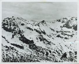
Photographs depict aerial views of the Cassiar townsite, plantsite, tailings pile, mine road, bench and pit mine, mine buildings (tramline loading station, crusher, shop, and garage), and surrounding mountain range. Here "aerial" refers to photos depicting a large area and taken from the air or from a high point of elevation.

2000.1.1.3.13.04 · Item · [before 1970]
Part of Cassiar Asbestos Corporation Ltd. fonds

Photograph depicts the Cassiar townsite behind shadow in foreground. Plantsite can be seen including the mill, dry rock storage building, tailings pile, and many other buildings. Mountains in background. Handwritten annotation on recto: "<- 13 1/2" ->". (This photograph was made into a promotional poster.)

Catharine Parr Traill
2002.14.1.06.14 · File · 2002-2005
Part of Marianne (Marika) Ainley fonds

File consists of research materials on Catharine Parr Traill including photocopied research materials, Ainley's drafts, and research notes.

Catharine Parr Traill
2002.14.1.06 · Subseries · 1993-2006
Part of Marianne (Marika) Ainley fonds

Subseries contains Ainley's research material on Catherine Parr Traill (nee Strickland). The subseries includes research for and manuscripts of: the conference presentation and book chapter, "Science in Canada's 'Backwoods'?: Catharine Parr Traill" (originally titled, "Catharine Parr Traill (1802-1899): A Woman Science Writer in 19th Century Canada"); the conference presentation, "Women and the Popularization of Science: 19th-century Women Science Writers in Canada"; and the conference presentation, "Colonial Lessons: Catherine Parr Traill (1802-99) and Popular Science Education in Upper Canada"; and publication "Circulating Gendered Knowledge: Catharine Parr Traill's Colonial Science Lessons, 1836-1895." Subseries consists of photocopied archival material, research notes, overhead transparencies, correspondence, manuscripts, and articles.

Cayoosh Valley
2012.13.1.54.10 · Item · July 1977
Part of J. Kent Sedgwick fonds

Image depicts a view of Cayoosh Valley. Cayoosh Creek is visible in the bottom left corner of the image.

Cemetery
2012.13.1.78.21 · Item · 1982
Part of J. Kent Sedgwick fonds

Image depicts an individual crouching in an old cemetery located somewhere in the coastal forest on Haida Gwaii, B.C.

Cemetery
2012.13.1.6.157 · Item · Nov. 1980
Part of J. Kent Sedgwick fonds

Image depicts a cemetery at an uncertain location, possibly in Fort St. James, B.C.

Centre Street Prince Rupert
2009.7.1.251 · Item · ca. 1880-1920
Part of Archdeacon W. H. Collison fonds

Photograph of residents in motion on Centre Street in Prince Rupert. Buildings are visible on either side of the street and a railway track runs down the length of the road. Annotation on recto reads: "Centre Street, Prince Rupert, BC. 1664."

Chasm
2012.13.1.50.126 · Item · 1981
Part of J. Kent Sedgwick fonds

Image depicts a chasm full of trees at an unknown location.

Chasm
2012.13.1.50.128 · Item · 1981
Part of J. Kent Sedgwick fonds

Image depicts a chasm full of trees at an unknown location.

Chasm Wall
2012.13.1.50.127 · Item · 1981
Part of J. Kent Sedgwick fonds

Image depicts the wall of a chasm full of trees at an unknown location.

Chetwynd
2012.13.1.91.32 · Item · Nov. 1978
Part of J. Kent Sedgwick fonds

Image depicts a view of Chetwynd, possibly from Highway 97.