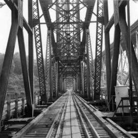
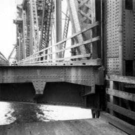
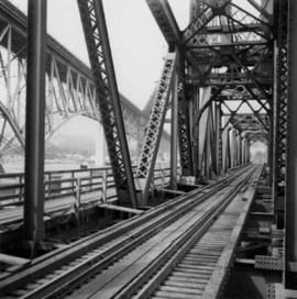
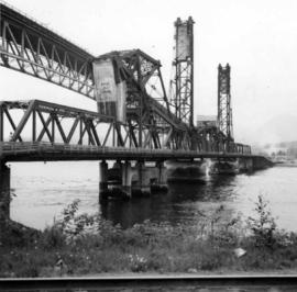
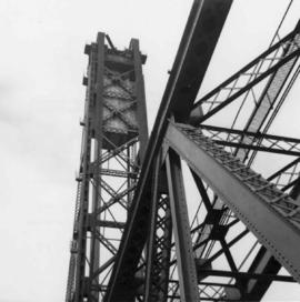
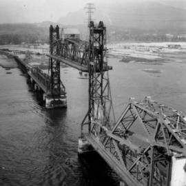
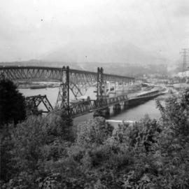
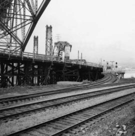
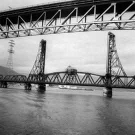
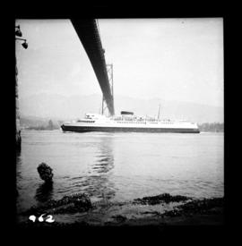
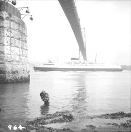
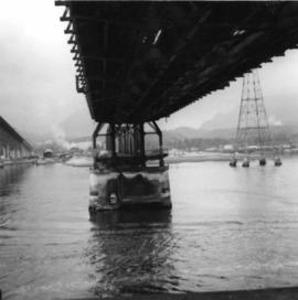
Photograph depicts the underside of the lifting span of the Second Narrows Railway Bridge in Vancouver, BCView is from the south, fixed side.
Photograph depicts the Second Narrows Railway Bridge in Vancouver, BC; view from the lifting span looking south.
Photograph depicts the lifting span of the Second Narrows Bridge with a motor car on the west roadway, as the span is about to close to its normal, flush position.
Photograph depicts the Second Narrows Railway Bridge in Vancouver, BC, from a view on the lifting span looking north.
Photograph depicts the Second Narrows railway bridge in Vancouver from the south bank. The bascule does not move.
Photograph depicts the north side lifting tower of the Second Narrows railway bridge in Vancouver, BC
Photograph depicts the Second Narrows Railway Bridge in Vancouver, BCwith the lifting span up.
Photograph depicts the road and rail bridges at Second Narrows, Vancouver B.C. The photograph was taken from Boundary Rd. looking north.
Photograph depicts the rail approach to the Second Narrows Railway Bridge in Vancouver, BCThe shot taken on CPR trackage and from underneath the road bridge on the south bank.
Photograph depicts the Second Narrows Railway Bridge, looking east.
Photograph depicts the Canadian National Railway (CN) Second Narrows railway bridge in Vancouver harbour. It was completed and ready for traffic about May 1969. The view is looking north.
Photograph depicts a section of floating dock on the north shore of the Vancouver Harbour, between Lynn Terminals and the Second Narrows Bridge. It is one of four sections and arrived here in mid 1965.
Photograph depicts the Shaughnessy Golf Course abandoned but still played upon. There is an excavator working on drainage for a subdivision in the middle distance. The view is looking southwest from the corner of the course at Oak and 33rd Ave. in Vancouver, BC
Photograph depicts Shaughnessy Golf Course after its closure but before its destruction. The view is looking east from the clubhouse at the first tee and fairway.
Photograph depicts Stan Rowebotham and Ted Izzard in front of the disused club house of the abandoned Shaughnessy Golf Course.
Photograph depicts Shay #115 engine at work at the Pacific Coast Terminals in North Vancouver.
Photograph depicts the boiler side of Shay locomotive #115 at the car tippler. It is located at the Pacific Coast Bulk Terminals in North Vancouver.
Photograph depicts Shay #115 locomotive at the Pacific Coast Bulk Terminals in North Vancouver. The engineer on locie is J.B. Kay, 4127 Yale St., in north Burnaby. He was a logging railway engineer in 20s and 30s, and then later on main line.
Photograph depicts a ship the "Laurier", which may have been a Fisheries Protection Vessel, at the Federal Immigration Dock in Vancouver.
Photograph depicts the ship the "Princess Louise" at Lynn Terminals in Vancouver Harbour.
Photograph depicts the ship the "Princess Louise" prior to departure at Lynn Terminals, North Vancouver. She had been tied to this wharf for at least 18 months.
Photograph depicts the ship the "Princess Louise" at Lynn Terminals in Vancouver Harbour before departure for California. It has one poorly applied coat of white paint. The anchors have been removed and the towing tackle placed in position.
Photograph depicts the ship the "Princess Louise" under tow at about 7:30 pm, passing Brockton Point in Vancouver Harbour.
Photograph depicts the ship the "Princess Louise" under tow and just passed under the Lions Gate Bridge in Vancouver.
Photograph depicts the ship the "Princess Louise" under tow by the Vancouver tug "la Pointe", just west of the First Narrows.
Photograph depicts the ship the "Princess Louise" under tow by the Vancouver tug "La Pointe", going through the First Narrows. Just before going through the current took her at 45 degrees to the course and for a moment it looked as if she might run aground.
Photograph depicts the ship the "Princess of Vancouver" emerging westwards from the First Narrows in Vancouver.
Photograph depicts the ship the "Princess of Vancouver" passing Lions Gate Bridge in Vancouver, outward bound.
Photograph depicts the ship the "Princess of Vancouver" outward bound at midday. It is passing below the Lions Gate Bridge in Vancouver.
File contains photographs pertaining to the transportation of asbestos fibre.
- These include portraits of Clinton trailer trucks, trucks from the Cassiar Transport Division at Mile 860 on the Alaskan Highway, the assembly of large freight trucks, an unidentified bridge, and ships and buildings at the Cassiar Shipping Facilities at Pier 94 on the Asbestos Warf in North Vancouver, B.C.
- Twenty-three photographs dated 1982 depict asbestos fiber bales on pallets and inside shipping containers, with accompanying annotations commenting on the quality of the packing. Several images show fibre bales broken during shipment. An accompanying note reads: "SMD - please ensure this cannot reoccur.", and a photo caption reads: "pierced bags are resulting as an environmental problem as fibre is beginning to build up in certain containers." One of the photographs depicting the Cassiar Transport Division was used for promotional posters with the following commentary: "The Cassiar Transport Division operates out of Whitehorse, Yukon Territory and is responsible for delivering the asbestos to the White Pass and Yukon Route terminal in Whitehorse. Fuel oil and supplies are backhauled to the mines. By the end of 1967, the fleet will consist of 65 tractor-trailer units, each of which will carry 23 tons of asbestos. The distance from Whitehorse to Cassiar is 357 miles and Clinton is 403 miles. During the past year, the Division's trucks traveled 2,213,534 miles and handled 75,100 tons, and the mileage to 3.5 million miles. This is a year-round operation and convoys arrive at the mine daily in spite of the long difficult haul. The Division currently employs 43 drivers and 35 mechanics and operates its own maintenance and rebuild facilities in Whitehorse. Over the years these men have established and enviable record of safety, cost and performance."
- Additional photographs that have been integrated depict the Asbestos wharf and its condition, 31 slides of wharf, maps of shipping routes, storage, forklifts, shipping trucks, and packaged asbestos.
- Also included in this file are two copies of a "Photo Survey - Cassiar Ton Units - "Amstelveld & Trojoland" on arrival to Brisbane & Sidney - August 1967." This collection of photographs is a part of an assessment of the efficiency of shipping and transport to Australia from Cassiar. Pictures include: loading, forklifts, storage, ripped bags, broken straps, wharfs, trucks, slings. There are accompanied annotations with each of the photos explaining the safety hazards or inefficiency of the situation. This report was found inside a box linked to James Hardie Industries Ltd. This company is not mentioned in the photograph annotations, but could be related to the report since James Hardie Industries Ltd. was a key player in asbestos mining and manufacturing in Australia.
- Collection of photos of roadside spill of Asbestos, depicting a man with shovel cleaning up on 5 June 1985
- Photos from Eternit Societe Anonyme (a European company that Cassiar shipped to) of packaged Asbestos in storage in 1967
- Collection of photos of James Hardie Coy. Pty. Ltd. shipment of asbestos that was not stored or transported effectively. Many photos depict broken bags as a result of inadequate storage and forklift punctures.
- Collection of photos of Cassiar/Stewart Road Proposal. Photos depict tests of the various stages of shipping and transportation process including forklift tests, Marineo Sling tests, stacking tests, durability tests, container loading tests, problems with current units etc. Also included is a marketing drawing if proposed shipping plan - drawn by "Stewart 1977."
- Photos of shipping process of Turners Asbestos Fibres Lmt. Photos depict lowering asbestos pallets onto barge with swing, and storage on barge.
- Collection of photos of a shipment of asbestos, but the bags of fibre are not identified as a Cassiar shipment therefore the location is unknown.
File consists of documentary photographs taken by David Davies of various ocean passenger vessels in British Columbia
Photograph depicts the site of a former C.P.R. connection between the mainline into Vancouver and False Creek yards at West Pender St. In Vancouver. The rails are not used but still appear in the street and on the parking lot on the far side. Another parallel set of tracks 30 yards to the east are in daily use.
Photograph depicts the site of the former Marpole inter-urban depot, looking east.
Photograph depicts the site of former single tram tracks going east up Frances St., near Commercial Dr., in east Vancouver, BC
Photograph depicts Siwash Rock in Stanley Park British Columbia.
Photograph depicts snowplow #S103, which was an ex-electric stock, stored at the Kitsilano Workshop yards in Vancouver. It was converted from electric locomotive #952 built by 1911 by the B.C. Electric Railway and rebuilt in 1937.
Photograph depicts the south shore line of the B.C. Electric Railway in False Creek, Vancouver. B.C. Hydro operated it, if not owned it. The location was directly opposite from Granville Island.
Photograph taken at the east end of False Creek, looking south towarsd Quebec and Ontario Streets.
Photograph depicts special equipment opposite a car barn of the B.C. Electric Railway, at New Westminster.
Photograph depicts a steam crane at the Allied Shipbuilders Ltd. on 145 West First Ave in Vancouver, BC
Photograph depicts a steam grab working on the new dock to the west of Centennial Pier, on the site of a former Hastings mill in Vancouver, B.C. The view is looking north and the foreground depicts tidal water.
Photograph depicts the steam tug "Master" in English Bay, Vancouver during the maritime festival.
Photograph depicts the steam tug "Master" with the steam up at Kingcome Navigation Dock in Vancouver.
Photograph depicts the steam tug "Master" with steam up at Kingcome Navigation Dock in Vancouver. The C.N.R. wharf/terminal is at left.
Photograph depicts the steam tug "Master" tied up to N.H.B. elevator #4 on the southeast side of Vancouver Harbour.