
2020.05.28
·
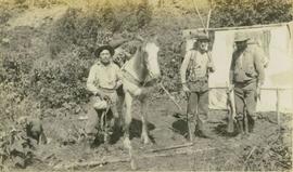
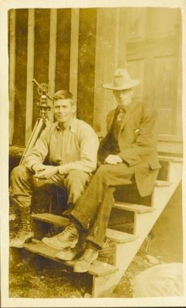
Item
·
[Sept. or Oct. 1936]
Part of Gordon Wyness Album
Photograph depicts (from left to right) Philip Monckton, Gordon Wyness, and Lavender Monckton at the Beaverly Geodetic Station, 7 miles west of Prince George. Surveying equipment (tripod, theodolite, and wire) are stationed at centre.

2009.7.1.292
·
Item
·
[ca. 1907-1920]
Part of Archdeacon W. H. Collison fonds
Photograph of post office and neighbouring building. Both buildings are composed of wood and tent materials. Annotation on recto reads: "Post Office & Customs House, Prince Rupert, BC."
2009.5.2.1
·
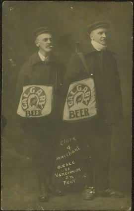
Item
·
1909
Part of Taylor-Baxter Family Photograph Collection
Photograph depicts two men posed with "CALGARY BEER" bags slung over shoulders. Handwritten annotation on verso of photograph: "Clark & Marchant Quebec to Vancouver on Foot", on recto: "To H F Glassey With Every Good wish. from Leo Marchant. Pearson's Magazine 1909."
2003.13.1.2.274
·
Item
·
[19-?]
Part of Parker Bonney Photograph Collection

2009.7.1.281
·
Item
·
[ca. 1880-1920]
Part of Archdeacon W. H. Collison fonds
Wide angle photograph of Prince Rupert sometime during the winter. There is snow on the ground and a marge mountain range is visible in the background. Annotation on recto reads: "Prince Rupert looking East from Waterworks J.D.A Pho 5/2."

2009.7.1.247
·
Item
·
ca. 1880-1920
Part of Archdeacon W. H. Collison fonds
Photo of entire ship building plant, including several vessels in the foreground. Hills are visible in the background. Annotation on recto reads: "Prince Rupert Ship Repair and Ship Building Plant. Prince Rupert BC. Frank E Kirby, William T Donnelly, Engineers. 17 Battery Place. NYC."

2009.7.1.273
·
Item
·
[ca. 1880-1920]
Part of Archdeacon W. H. Collison fonds
Photograph of a small vessel on the ocean with a dock and harbour buildings in the foreground. Tents and piles of lumber can be seen among the buildings. Annotation on recto reads: "The Wharf, Prince Rupert, BC. 1657." Printed annotation on verso reads "The Wharf, Prince Rupert, BC J. Howard A. Chapman, Victoria. BC. 1657."
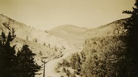
2020.05.36
·
Item
·
1936
Part of Gordon Wyness Album
Photograph depicts the rock formations along the Cariboo Road north of Cache Creek. Wyness notes that the rock may be sandstone; there may be red iron oxide visible in the formation.
2009.5.2.8
·
Item
·
[ca. 1911]
Part of Taylor-Baxter Family Photograph Collection
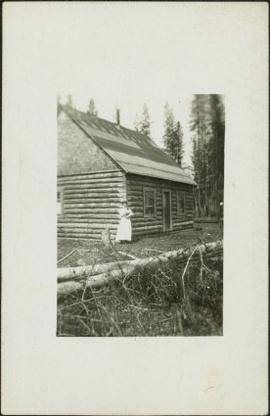
Photograph depicts Sarah Glassey, holding her fox terrier, and standing at corner of log house. Felled trees in foreground, forest trees in background. Photograph believed to have been taken on the 160 acres of land which Sarah purchased in the Kispiox Valley in 1911. She became the first single woman to pre-empt land in British Columbia. This house was built in a year with the help of a Gitxsan Elder.
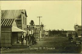
2006.20.11.2
·
Item
·
[ca. 1900]
Part of Northern BC Archives Historical Photograph Collection
Photograph depicts a street scene along Second St. in Fort George. Wagons line the dirt road which is flanked by wooden buildings. A group of unidentified men stand on the boardwalk outside of Rigg's Restaurant. Handwritten annotation along bottom of photograph: "Second St. Ft. George".

2009.7.1.274
·
Item
·
May 1908
Part of Archdeacon W. H. Collison fonds
Side view photograph of a small harbor close by a shoreline littered in organic debris. A foggy mountain range is visible in the background. Annotation on recto reads: "Wharf and Harbor Prince Rupert. May 1908 JDA."
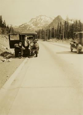
2020.05.01
·
Item
·
6 June 1936
Part of Gordon Wyness Album
Photograph depicts a man, likely Gordon Wyness, sitting on the front of a 1930 Buick Series 40 car at the Snoqualmie Pass summit.
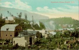
2011.3.3.116
·
Item
·
[ca. 1909-1930]
Part of North Coast & Central BC Postcard Collection
Hand coloured photo of various squatter's shacks and tents, with mountains in the background. Printed annotation on recto reads: "Squatters, Prince Rupert, B.C." Artist's stamp on lower right corner reads: "104,0033 J.V."
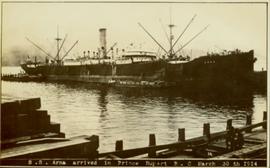
2009.7.1.267
·
Item
·
30 March 1914
Part of Archdeacon W. H. Collison fonds
Photograph of ocean liner SS Arna docked in a harbour. Foreground shows two individuals on a dock in the lower right corner and a large pile of lumber in the lower left corner. Annotation on recto reads: "S.S. Arna arrived in Prince Rupert B.C March 30th 1914"

2009.7.1.284
·
Item
·
1907
Part of Archdeacon W. H. Collison fonds
View of the road descending to the waterfront. Buildings and forested area are visible on either side of street. Annotation on recto reads: "Prince Rupert BC. '07."

2011.13.71
·
Item
·
ca.1910-ca.1930
Part of Parker photograph collection
Photograph is a printed postcard depicting a wagon track between buildings situated on either side. There are mountains in the back ground. Possibly Stewart, BC.
2003.13.1.2.038
·
Item
·
[19-?]
Part of Parker Bonney Photograph Collection

2020.05.42
·
Item
·
1936
Part of Gordon Wyness Album
Photograph depicts two surveyors (Jack Lee, Gordon Wyness, or Philip Monckton) taking bearings from Pineview Station tower east of Prince George. Their surveying transit and telescope are visible in the image.

2006.20.3.26
·
Item
·
[between 23 May 1906 and 15 October 1906]
Part of Northern BC Archives Historical Photograph Collection
Photograph depicts two unidentified men standing to right of flag mounted in rock pile.
Image is one of 65 photos documenting a survey of the Canada-Alaska Boundary, Taku River area, May 23 to Oct. 15, 1906.
This particular photo is one of 13 found in original enclosure with the following handwritten annotation: "SOME OTHERS." See also items 2006.20.3.22 - 2006.20.3.34.

2006.20.3.55
·
Item
·
[between 23 May 1906 and 15 October 1906]
Part of Northern BC Archives Historical Photograph Collection
Photograph depicts two unidentified men standing to right of flag mounted in rock pile.
Image is one of 65 photos documenting a survey of the Canada-Alaska Boundary, Taku River area, May 23 to Oct. 15, 1906. This particular photo is one of 10 found in original enclosure with the following handwritten annotation: "From [Wahut?]-Azmuth and Koshu.” See also items 2006.20.3.47 - 2006.20.3.56.

2006.20.3.61
·
Item
·
[between 23 May 1906 and 15 October 1906]
Part of Northern BC Archives Historical Photograph Collection
Photograph depicts two men on either side of camera on tripod, flag visible behind them. Mountain range and glacier in background.
Image is one of 65 photos documenting a survey of the Canada-Alaska Boundary, Taku River area, May 23 to Oct. 15, 1906. This particular photo is one of 9 found in original enclosure with the following handwritten annotation: "Pictures of different members of ‘our’ party.” See also items 2006.20.3.57 - 2006.20.3.65.
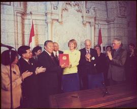
2009.6.1.543
·
Item
·
1999
Part of The Honourable Iona Campagnolo fonds
The group stands in front of an ornate stone wall and two Canadian flags.
Handwritten annotation on photograph enclosure reads: “8/6/99. Dear Lady, When I saw this photograph I knew there was a certain person who would truly appreciate and ‘feel’ its significance. Not many steps left to take now . . . . your unwavering support is never more appreciated. best personal regards, Peter”; handwritten annotation on verso reads: “Nisga’a”.

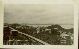
2009.7.1.280
·
Item
·
1908
Part of Archdeacon W. H. Collison fonds
Gathering of tents in Vickersville with the harbour and mountains in the distance. Annotation on recto reads: "Vickersville Prince Rupert o/n[?] 1908."

2011.3.3.119
·
Item
·
[ca. 1909-1930]
Part of North Coast & Central BC Postcard Collection
Hand coloured lofty view of the Prince Rupert waterfront. Printed annotation on recto reads: "The Beginning of Prince Rupert, B.C. : Grand Trunk Pacific Hotel in foreground." Artist's stamp in lower left corner reads: "104,036 J.V."

2009.7.1.263
·
Item
·
21 January 1914
Part of Archdeacon W. H. Collison fonds
Photograph of a large explosion next to a huge pile of debris. Buildings are visible on either side and railroad track can be seen in the foreground. Annotation on recto reads: "The Last Big Blast, Prince Rupert BC 21 Jan 1914 McRae Bros. Photo"

2011.3.3.85
·
Item
·
21 January 1914
Part of North Coast & Central BC Postcard Collection
Photograph of a large explosion next to a huge pile of debris. Buildings are visible on either side and railroad track can be seen in the foreground. Printed annotation on recto reads: "The Last Big Blast, Prince Rupert BC 21 Jan 1914 McRae Bros. Photo"
2009.7.1.279
·
Item
·
6 August 1909
Part of Archdeacon W. H. Collison fonds
Wide angle photograph showing 3rd and 2nd Avenue in Prince Rupert. Many buildings, both commercial and residential, and some tents are situated along the wooden roads. Annotation on recto reads: "Prince Rupert, BC. 3rd Avenue 2nd Avenue Allen Photo Aug 6/09."
2009.7.1.282
·
Item
·
6 August 1909
Part of Archdeacon W. H. Collison fonds
Wide angle photograph showing the intersection of 3rd Avenue and 6th Street, as well as 5th Street in Prince Rupert. Many buildings are visible along the wooden street including a building in mid-construction. Annotation on recto reads: "Prince Rupert, BC. 6th Street 3rd Ave. 5th St Allen Photo Aug 6/09."
2020.05.39
·
Item
·
1936
Part of Gordon Wyness Album
Photograph depicts the town of Clinton. Wyness noted on the photograph verso that the survey crew had dinner here on their return trip in October 1936. In addition, the album caption notes that Clinton was the location of British Columbia's oldest hotel.
2020.05.46
·
Item
·
1936
Part of Gordon Wyness Album
Photograph depicts the town of Hope in October 1936.

2020.05.37
·
Item
·
1936
Part of Gordon Wyness Album
Photograph depicts the town of Lytton in October 1936.
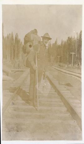
2011.13.32
·
Item
·
ca.1910-ca.1930
Part of Parker photograph collection
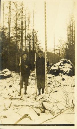
Photograph of two men posing with large surveyor's measuring sticks in a forested area during winter.
2011.13.31
·
Item
·
ca.1910-ca.1930
Part of Parker photograph collection
Photograph of two men relaxing on some short exterior stars. A surveying transit can be seen in the background.
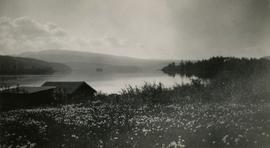
2020.05.53
·
Item
·
1936
Part of Gordon Wyness Album
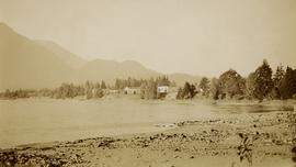
Photograph depicts a view of Burns Lake, as seen from the survey crew's temporary lodgings at the cabin of Ben[?] Smith. Wyness notes in the photograph transcription that float planes landed in the bay below the buildings visible in this image.
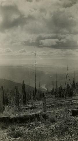
2020.05.08
·
Item
·
October 1936
Part of Gordon Wyness Album
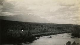
Photograph depicts a view of the Fraser River from what Wyness calls "Fraser Mountain". There are a number of places named "Mount Fraser" in British Columbia, but the exact location of where this photograph was taken is unclear.
2020.05.32
·
Item
·
June 1936
Part of Gordon Wyness Album
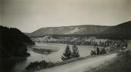
Photograph depicts a view of Fraser River from the Soda Creek hill in June 1936. Wyness notes that photograph was taken at mile 200, which was approximately 167 miles from Ashcroft.
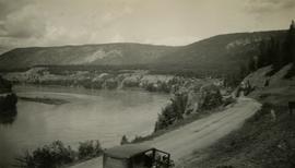
2020.05.33
·
Item
·
Oct. 1936
Part of Gordon Wyness Album
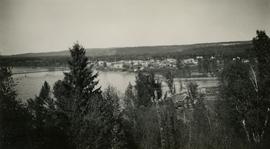
Photograph depicts a view of Fraser River from the Soda Creek hill in October 1936. The town of Soda Creek is barely visible at right.

2020.05.43
·
Item
·
1936
Part of Gordon Wyness Album
Photograph depicts a view of Front Street and Quesnel Hotel from Fraser River Bridge in Quesnel. Visible buildings include the Quesnel Hotel Cafe, the Quesnel Hotel, and John A. Fraser & Co. Ltd.
2020.05.20
·
Item
·
[Sept. or Oct. 1936]
Part of Gordon Wyness Album
Photograph depicts a view of Hudson Bay Mountain taken from the Telkwa water tower. The Monckton survey crew tent, their car, and the railway track is also visible.

2020.05.25
·
Item
·
[Sept. or Oct. 1936]
Part of Gordon Wyness Album
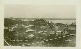
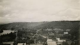
Photograph depicts a view of the city of Prince George looking west from the east hill. The confluence of the Fraser River and Nechako River is visible to the right. The Grand Trunk Pacific Railway bridge is visible at centre. The current location of where this photograph may have been taken is likely somewhere near where Highway 16 rises on the hill past the correctional centre (jail).
2020.05.45
·
Item
·
1936
Part of Gordon Wyness Album
Photograph depicts a view of the town of Quesnel from a southeast hill. Fraser River and the Fraser River Bridge are visible at left, the Quesnel River at right.

2009.7.1.252
·
Item
·
ca. 1880-1920
Part of Archdeacon W. H. Collison fonds
View of the road descending to the waterfront. Buildings and forested area are visible on either side of street. Mountains clear in the background.
2020.05.21
·
Item
·
[Sept. or Oct. 1936]
Part of Gordon Wyness Album
Photograph depicts a view of the town of Telkwa, BC from the perspective of the Telkwa water tower.
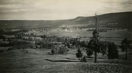
2020.05.09
·
Item
·
Sept. 1936
Part of Gordon Wyness Album
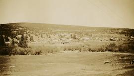
Photograph depicts a view of the community of Williams Lake, taken from the Chilcotin Road to the west.

2023.5.1.43
·
Item
·
9-10 July 2020
Part of UNBC School of Planning and Sustainability fonds
Drawing depicts visual notes taken at the 2020 Public Health Summer Institute with the theme "Think Globally, Act Locally: Public Health and the Anthropocene". Themes related to the COVID-19 pandemic are depicted.