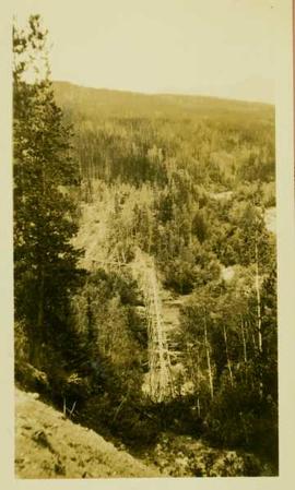
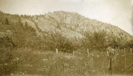
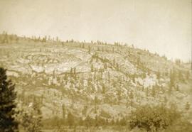
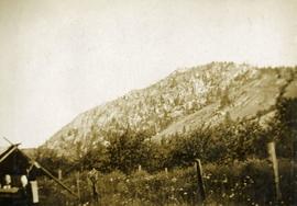
Photograph depicts a ditch cut into a forested landscape. Handwritten annotation on recto of photograph reads: "New Germansen ditch length 10 miles; width of ditch bottom 15 feet"
Image depicts the Germansen River, with the buildings of Germansen Landing visible on the other side.
Image depicts a child in the foreground, and the Germansen Landing trading post in the background in Germansen Landing, B.C.
Image depicts a helicopter in Germansen Landing, B.C.
Image depicts the Germansen Landing Trading Post.
Photograph depicts a landscape perspective of Germansen Placers including the pipeline.
Image depicts an unknown woman standing in front of a truck that either weighs 80 tonnes, or is capable of carrying that much; the slide is simply labelled "80 tons." It is located at the Gibraltar mine site.
Image depicts the interior of the Gibraltar chemical mill, where they separate the molybdenum.
Image depicts the Gibraltar mine site north of Williams Lake, B.C.
Image depicts an 80 tonne truck full of rocks at the Gibraltar mine site north of Williams Lake, B.C.
Image depicts a number of workers putting in blasting powder at the Gibraltar mine site north of Williams Lake, B.C.
Image depicts a loading truck at the Gibraltar mine site north of Williams Lake, B.C.
Image depicts an aerial view of the Gibraltar mine site's pits and waste dumps, north of Williams Lake, B.C.
Photograph depicts Henry Cleburn Giegerich and Emil Bronlund with Swannell's party posed in front of Jack Duncan's cabin near Thutade Lake.
Giles stands between banquet tables, John can be seen clapping in centre background.
Handwritten notations affixed to verso read: “Giles Turner (blackdress)” and “John Turner[Liberal Party Leader]”.
Photograph depicts a field and fence in the foreground, an orchard in the midground, a rocky mountain slope in the distance.
Photograph depicts a rocky, mountain slope.
Photograph depicts a field and fence in the foreground, an orchard in the midground, a rocky mountain slope in the distance.
Photograph depicts a large elaborate church building. Handwritten annotation below photograph reads, "Gospel Mill at Kincoolith - Naas River".
Image depicts the Ginter House in Prince George, B.C.
Image depicts the Ginter House and the surrounding woods, in Prince George, B.C.
Image depicts the Ginter House in Prince George, B.C.
Image depicts what appears to be a part of a fence on the Ginter Property in Prince George, B.C.
Image depicts a swimming pool filled with debris in the interior of the Ginter House in Prince George, B.C.
Image depicts the interior of the Ginter House in Prince George, B.C.
Image depicts a private driveway, most likely leading to the Ginter Property in Prince George, B.C.
Image depicts a road near the Ginter House in Prince George, B.C.
Image depicts the Ginter Property in Prince George, B.C.
Photograph depicts an existing girder bridge, in use since 1962. A new concrete bridge was being built on the left.
Photograph depicts an old girder bridge.
Photograph depicts a covered wooden grider bridge of the former Great Northern Railway spur that ran from north Washington state into B.C. at Keremeos, then west to Princeton. It was now only operating as far north as Keremeos.
Photograph depicts a covered grider bridge of a former railway (subsidiary of the Great Northern Railway, built in 1907-14) that formerly ran between Keremeos and Princeton, but had long since been lifted. The bridge was now used by vehicles going to a nearby ranch.
Young girl stands with dog in front of an adult on flatbed pulled by horse in foreground. Fence, building, trees, and hills in background. Handwritten annotation on recto of photograph: "[Gineva?] - and Eleanor (my niece)."
Item is a photograph of the girls basketball team in Salmon Arm. Ray Williston is on the left.
Photograph depicts girls dancing at the opening of the Haisla Recreation Centre in Kitamaat Village.
Photograph depicts a girls' school, Strathcona Lodge, at Shawnigan Lake.
Image depicts the Giscome, B.C. town site with the Giscome railway station and the Giscome store in the center surrounded by vehicles. Map coordinates 54°04'18.5"N 122°21'57.7"W