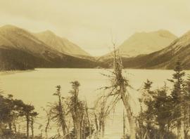
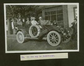
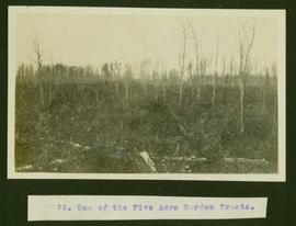
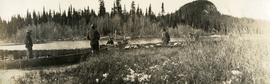
Photograph depicts open range land with sparsely forested pine in the background.
Photograph depicts a log "snake" fence surrounded by open range land and low hills.
Photograph depicts open range land with forest in the background.
Photograph depicts open range land, stumps in the foreground and some small buildings with a river behind in the distance.
Photograph depicts grassy vegetation, open range land.
Image depicts an open mining pit at an uncertain location; it is possibly Gibraltar.
Image depicts a field in Giscome, B.C. On the right side of the image, in the background, is a grey strip that appears to be a mine, possibly the quarry at Eaglet Lake in Giscome, B.C. Map coordinates 54°03'52.9"N 122°22'10.0"W
Image depicts an open field and Giscome, B.C. in the background. Map coordinates 54°03'52.9"N 122°22'10.0"W
Image depicts an open field and numerous buildings, including a church in Giscome, B.C. Map coordinates 54°04'03.2"N 122°22'04.6"W
Handwritten caption beside this photo reads: "1500wt 4x4". Photograph depicts small open cab truck with tire chains. Forest and unidentified buildings in background. A second vehicle is semi-visible on far left, as well as a pile of logs on far right.
Photograph depicts a group of men gathered around hole in ice. Two men in centre handle a net full of fish. Village can be seen on shore in background.
Handwritten annotation on verso reads: "Oolichan Fishing Nass River".
Photograph depicts groups of men gathered on ice. One man sits on ice sled in foreground. Village can be seen on shore in background.
Handwritten annotation on verso reads: "Chapt. II. No. 1. Fishing Bay. Olachan fishery on the ice."
Photograph depicts two men standing beside beds of fish laid out to dry. More oolichan fish hang on tall structures in background.
Handwritten annotation on verso reads: "'Food for winter' Oolichans drying at Fishing Bay, Nass River".
Image depicts the Onward Ranch near Williams Lake, B.C.
Photograph depicts Onion Lake as seen through a barren tree line. In the background a mountain range surrounds the shores of the lake.
Typed caption glued to album page directly below photograph reads: "76. One of the Five Acre Garden Tracts." Photograph depicts a wooded lot. Photographer: Dominion Stock & Bond Corporation.
Typed caption glued to album page directly below photograph reads: "63. One of the 1st residences built at Fort Fraser." Photographer: Dominion Stock & Bond Corporation.
Photograph depicts a man standing on the edge of a trail looking to the treed hills in the distance.
Typed caption glued to album page directly below photograph reads: "17. On the way to Fort Fraser by auto." Photograph depicts a group of men standing, and one on horseback, around an automobile packed with luggage of all shapes. Photographer: Dominion Stock & Bond Corporation.
Typed caption glued to album page directly below photograph reads: "35. On the way to Fort Fraser." Photograph depicts six men in overcoats and hats sitting in an automobile parked at curbside. Photographer: Dominion Stock & Bond Corporation
Photograph depicts man (presumably A.H. Holland) with survey pole standing next to loaded pack horse.
Photograph depicts a ranch home and barn along the road from Lillooet to Clinton. The location is believed to be a homestead 2 miles south of Pavilion Station. Two cars are parked beside the property, with a number of men nearby.
Image depicts a lake somewhere along what is possibly the Atlin Road to Atlin, B.C.
Photograph depicts thickly forested area.
Photograph depicts five men with a loaded wagon, pulled by a team of two horses.
Photograph depicts four men with a loaded wagon, pulled by a team of two horses. The wagon is approaching a small bridge on a dirt road. There is a forest in the background, a small stream in the foreground.
Photograph depicts two canvas tents set up near the shore of a small lake or stream. There is a wooden structure on the opposite side of the water. Rough cleared land in the foreground, forested hills and low mountains in the background.
Photograph depicts several men standing on the river bank. Possibly A.H. Holland in center of photo.
Front view of two men sitting on a pile of supplies with a mountain in the background. Printed annotation on recto reads: "On the Divide Enroute to Naas #96."
Photograph depicts three boats on the edge of a small river. Two men attend each boat. Wild grasses with a skiff of snow in the foreground, river, forest and a low forested bluff in the background.
Image depicts a cabin on the "west arm" of Takla Lake.
Image depicts the "west arm" of Takla Lake.
Image depicts the "north-west arm" of Takla lake.
Image depicts a mountain and Takla Lake.
Image depicts a view of Takla Lake, "looking south-east."
Image depicts a view of Takla Lake, "looking north-west."
Image depicts a view of Takla Lake.
Photograph taken on the shores of Wood Lake, a very picturesque stretch.
Photograph depicts a man resting in a canoe near the right shore of a river leading through a forested environment with a mountain range visible in the background.
Image depicts several individuals walking on a trail somewhere near Raven Peak.
Photograph depicts a view near Nootka, looking north towards Bligh Island. Photo taken from the M.V. Uchuck III.
Photograph depicts a view of Friendly Cove, near Nootka, on the west coast of Vancouver Island. View is taken from the M.V. Uchuck III.
Image depicts four individuals canoeing on Lanezi Lake.
Image depicts two individuals canoeing on Lanezi Lake.