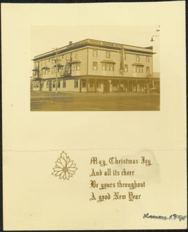
Showing 815 results

Archival description
Pineview
2012.13.1.3.146 · Item · [199-?]
Part of J. Kent Sedgwick fonds

Image depicts Pineview on Buckhorn Lake Road, Prince George, B.C.

Powerline
2012.13.1.3.037 · Item · Nov. 1977
Part of J. Kent Sedgwick fonds

Image depicts power lines east of the pulp mills in Prince George, B.C.

Prince George
2012.13.1.3.046 · Item · Jan. 1978
Part of J. Kent Sedgwick fonds

Image depicts a view of Prince George from City Hall looking northeast along George Street. Map coordinates 53°54'46.3"N 122°44'41.9"W

Prince George
2012.13.1.3.077 · Item · May 1984
Part of J. Kent Sedgwick fonds

Image depicts downtown Prince George looking northwest. Map coordinates 53°54'48.7"N 122°44'45.6"W

Prince George
2012.13.1.3.078 · Item · May 1984
Part of J. Kent Sedgwick fonds

Image depicts a view of Prince George from City Hall looking northeast along George Street. Map coordinates 53°54'46.3"N 122°44'41.9"W

Prince George
2012.13.1.3.135 · Item · 12 Oct. 1989
Part of J. Kent Sedgwick fonds

Image depicts Prince George, possibly with the Northwood Pulpmill in the background.

Prince George
2012.13.1.3.133 · Item · 12 Oct. 1989
Part of J. Kent Sedgwick fonds

Image depicts Prince George, possibly with the Northwood Pulpmill in the background.

Prince George
2012.13.1.3.169 · Item · Mar. 2003
Part of J. Kent Sedgwick fonds

Image depicts an aerial view of what is possibly an outlying area of Prince George, B.C.

Prince George
2012.13.1.3.042 · Item · Nov. 1977
Part of J. Kent Sedgwick fonds

Image depicts downtown Prince George looking northwest across Dominion Street. Map coordinates 53°54'48.7"N 122°44'45.6"W

Prince George
2012.13.1.3.134 · Item · 12 Oct. 1989
Part of J. Kent Sedgwick fonds

Image depicts Prince George, possibly with the Northwood Pulpmill in the background.