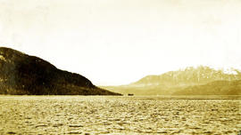
Showing 17269 results

Archival description
2009.7.1.299 · Item · 1 July 1909
Part of Archdeacon W. H. Collison fonds

Large crowd gathered on the street in downtown Prince Rupert around a lavishly decorated arch which reads "Come One Let 'Em All Come Come All. Welcome to Prince Rupert." Annotation on recto reads: "Arch Prince Rupert, BC. Dominion Day Celebration 1909. Allen Photo."

2009.7.1.257 · Item · 1 July 1909
Part of Archdeacon W. H. Collison fonds

Photograph of a large crowd in formal wear gathered on a slope. Some spectators can be seen perched atop extremely high poles. Annotation on recto reads: "The Crowd at Prince Rupert's Dominion Day Celebration 1909. Allen Photo 1-7-09."

2020.08.38 · Item · [between 1912 and 1916]
Part of Pacific Great Eastern Railway Region Photograph Collection

Photograph depicts an event on Lillooet Main Street with spectator crowds. The Union Jack and Canadian Red Ensign flags suggest this may be a Dominion Day event. The Lillooet community put on large, multi-day Dominion Day events between 1912 and 1916 with many planned activities. The particular activity depicted in this photograph may be a horse race or rodeo-type event. Main Street businesses visible include the Lillooet Restaurant, the Lillooet Pool Hall, and the "OK" Baths.

2020.08.40 · Item · [between 1912 and 1916]
Part of Pacific Great Eastern Railway Region Photograph Collection

Photograph depicts an event on Lillooet Main Street with spectator crowds. The Union Jack and Canadian Red Ensign flags suggest this may be a Dominion Day event. The Lillooet community put on large, multi-day Dominion Day events between 1912 and 1916 with many planned activities. The particular activity depicted in this photograph appears to be a horse race event. Main Street businesses visible include the Lillooet Restaurant and the "C.A. Phair General Merchant" store.

2011.3.3.21 · Item · 1914
Part of North Coast & Central BC Postcard Collection

Crowd is gathered for Dominion Day Parade. Decorated float can be seen in centre of street, and Hotel Prince Rupert stands in background. Printed annotation on recto reads: “Dominion Day Prince Rupert 1914 Photo W.W.W.” Handwritten message in ink on verso is addressed to “Mr. S. Smart 2550 Blackwood St Victoria B.C.”

2009.10.3.02 · Item · [between 1923 and 1926]
Part of Fred Jeffery Photograph Collection
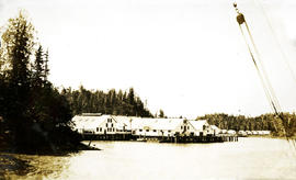
Photograph depicts a view of the ocean, water in the foreground, a peninsula jutting to the ocean and snow capped mountains in the distance. Handwritten annotation below photograph reads, "Double ID Point Naas River".

Doug Rolfs at Anzac River
2022.03.1.32 · Item · 12 Oct. 1975
Part of Stowell Forestry Collection

The photograph depicts Doug Rolfs overseeing bridge construction over the Anzac River. A crane can be seen on the uncompleted bridge. Annotation on reverse side of the photograph states, "The Pas Lumber Company Ltd Oct 12/1975, Anzac River - Colbourne Road, Quadra Coast, Doug Rolfs, foreman"

2004.6.07 · Item · [between 1920 and 1940]
Part of Stuart Lake Photograph Collection

Typed annotation on recto: "Douglas Lodge Scenes Stuart Lake, B.C." Man and woman standing with fishing gear in front of log fishing bungalows in forest. Tree trunks in foreground. It is believed that this couple may be the same two people pictured in item 2004.6.28, (possibly the Factors).

Downtown Aleza Lake
2007.1.25.7.21 · Item · 1925
Part of Aleza Lake Research Forest fonds

Item is a photograph of a copy print, resulting in a low quality photographic reproduction. Reproduced as a print, slide, and a negative. Location of original photograph is unknown.

Downtown Prince George
2012.13.1.3.082 · Item · May 1984
Part of J. Kent Sedgwick fonds

Image depicts downtown Prince George taken from City Hall looking north. Map coordinates 53°54'46.2"N 122°44'43.9"W

Downtown Prince George
2012.13.1.3.076 · Item · May 1984
Part of J. Kent Sedgwick fonds

Image depicts a view of Prince George from City Hall looking northeast with the pulp mills in the background. Map coordinates 53°54'46.3"N 122°44'41.9"W

Downtown Prince George
2012.13.1.3.080 · Item · May 1984
Part of J. Kent Sedgwick fonds

Image depicts downtown Prince George taken from City Hall looking north. Map coordinates 53°54'46.2"N 122°44'43.9"W

Downtown Prince George
2012.13.1.3.081 · Item · May 1984
Part of J. Kent Sedgwick fonds

Image depicts downtown Prince George taken from City Hall looking northwest. Map coordinates 53°54'46.2"N 122°44'43.9"W

Downtown Prince George
2012.13.1.3.079 · Item · May 1984
Part of J. Kent Sedgwick fonds

Image depicts downtown Prince George taken from City Hall looking northwest. Map coordinates 53°54'46.2"N 122°44'43.9"W

2012.13.1.3.108 · Item · 12 Oct. 1989
Part of J. Kent Sedgwick fonds

Image depicts 4th Ave at Quebec St, showing the following businesses: The Yarn Barn, Golden Chalice Jewellers, Dandy Lines, Ultrasport, and Saveco. Map coordinates 53°54'58.6"N 122°44'47.5"W

2012.13.1.3.110 · Item · 12 Oct. 1989
Part of J. Kent Sedgwick fonds

Image depicts George St in downtown Prince George with City Hall in the background. Also visible are the Prince George Hotel, Ming's Inn Chinese Restaurant, Fraser Stationers Ltd., Weiner King food cart, and a movie theatre. Map coordinates 53°54'55.0"N 122°44'36.1"W

2009.7.1.296 · Item · 20 October 1907
Part of Archdeacon W. H. Collison fonds

Photograph of several buildings down the street in Prince Rupert, including the church. Lumber pallets are littered around the buildings. Annotation on recto reads: "Prince Rupert, BC. 20.10.07."

2011.13.24 · Item · ca.1910-ca.1930
Part of Parker photograph collection

Street view of various buildings in Stewart, BC, covered with a heavy layer of snow. Visible businesses include "The R. Boyd Young Co." and "Stewart Land Co." Printed annotation on recto reads: "Stewart B.C. Hughes 78."

Downtown Vancouver, B.C.
2013.6.36.1.003.093 · Item · Mar. 1966
Part of David Davies Railway Collection

Photograph depicts a view of downtown Vancouver taken from the east end of False Creek at the foot of Terminal Ave. The view is looking northwest. In the middle distance on the left is the pier of a railway bridge taking the Great Northern Railway line into the city. It was demolished in about 1915-1920 when a new Great Northern station was constructed.

Dozer on Cliff
2000.1.1.3.15.10 · Item · [ca. 1958]
Part of Cassiar Asbestos Corporation Ltd. fonds

Photograph depicts unknown man driving bulldozer on edge of mine area at high elevation. The dozer is an International model TD24 (manufactured between 1947 and 1955). A second man stands on edge of cliff, directing driver. Expansive mountain range in background.

2000.1.1.3.15.17 · Item · 1961
Part of Cassiar Asbestos Corporation Ltd. fonds

Photograph depicts unknown man driving bulldozer on edge of mine area at high elevation. Mine road can be seen below leading to Cassiar plant in background on left, townsite visible on right. South mountain range in distance. Handwritten annotation on verso of photograph: "1961".

Dr. Joselito Arocena fonds
2016.7 · Fonds · 1988-2019

Fonds consists of the research and professorial records of Dr. Joselito Arocena, a founding faculty member of UNBC. Arocena was an internationally-recognized soil scientist and UNBC’s first Canada Research Chair. His records demonstrate his accomplishments as an academic and researcher, as well as his many and varied interdisciplinary research endeavours. Also included are selections from Arocena’s extensive photographic slide collection which illustrate his teaching, research projects, and personal interests.

Arocena, Joselito