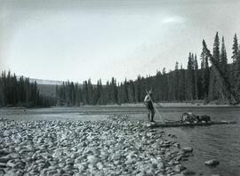
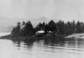
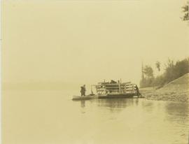
Showing 17231 results

Archival description
Quesnelle Forks Sign
2012.13.1.31.19 · Item · 1985
Part of J. Kent Sedgwick fonds

Image depicts Kent Sedgwick standing in front of a sign with a dog in Quesnelle Forks, B.C. The sign describes the history of the site, which began as a mining camp in 1859, but was later completely abandoned after a fire in 1866. It is now managed as a Forest Service Recreation Project.

2007.17.1.7 · Item · [ca. 1935]
Part of James Joseph Claxton Photograph Collection

Photograph depicts two wooden buildings in a snow covered forest environment. Photo is adhered to paper backing, upon which handwritten annotation on recto reads: “Quesnelle Quartz mining Company Hixon, B.C. Taken in mid nineteen thirties. Powerhouse from rear. Present day (1973) logging road would run through powerhouse at immediate rear of it at which you are looking. Tom Marsh Box 156 Squamish BC V0N 3G0 December 1978”

2007.17.1.6 · Item · [ca. 1935]
Part of James Joseph Claxton Photograph Collection

Photograph depicts two wooden buildings in a snow covered forest environment. Photo is adhered to paper backing, upon which handwritten annotation on recto reads: “Quesnelle Quartz Mining Co. Hixon BCTaken in mid 1930ies. Power house from rear. Present day (1973) Logging road would run through powerhouse at immediate rear of it at which you are looking. Tom Marsh Box 150 Squamish BC 1978.12”

Quesnel Quartz Mine Camp
2007.17.1.2 · Item · [ca. 1935]
Part of James Joseph Claxton Photograph Collection

Annotated overview of the Quesnel Quartz Mine Camp, with buildings numbered and a corresponding legend provided. Annotation on recto of photograph states: "1. BRIDGE OVER CREEK 2. BLACKSMITH SHOP 3. POWEROUSE 4. HEADFRAME OVER 200' SHAFT 5. OFFICE 6. WATER TANKS FROM POWERHOUSE 7. BUNKHOUSE 8. TRUCK 9. COOKHOUSE BEHIND #6 CANNOT BE SEEN" Additional annotation associated with photograph states: "We were always able to find the cookhouse even though hidden in this picture. Taken about 1935 by Russell Ross Supt. Quesnel Quartz Mine"

Queensborough bridge
2013.6.36.1.156.03 · Item · [July 1994]
Part of David Davies Railway Collection

Photograph depicts railway track previously owned by BCER. It led onto the east end of Lulu Island and then to Annacis Island. Looking from the Naew West River Walk to the Queensborough bridge that was protected by signals and had a high chain link fence to deter pedestrians. It was likely that the rail was only used at night. Originally built by Canadian Northern Railway to reach Steveston, circa 1917.

2013.6.36.1.063.19 · Item · 21 Feb. 1970
Part of David Davies Railway Collection

Photograph depicts the "Queen of the Islands" of B.C. Ferries, approaching the pier at the Long Harbour Terminal on the Gulf Islands. It was launched in 1963 and built by Burard Dry Dock Company Ltd. It had a capacity for 40 cars and 400 passengers.