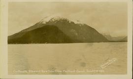
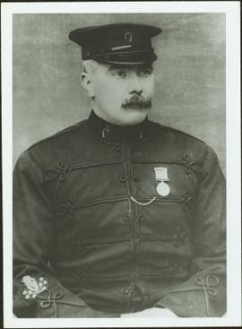
Photograph depicts portrait of an unidentified constable in military uniform wearing a medal.
Close view of young man in suit and tie, from elbows up. Believed to be either Dixon or Tom Taylor. See also item 2009.5.1.17.
Close view of young man in suit and tie, from elbows up. Believed to be either Dixon or Tom Taylor. See also item 2009.5.1.15.
Photograph of a young girl believed to be Katy Collison seated for a formal portrait on a wheeled chair. Handwritten annotation in pen on recto reads: "With love from 'Mama'[?] 1907." Handwritten address on verso reads: "Miss West[?] Metlakatla British Columbia N.W. America." Two half penny stamps affixed on verso and partially obscured by two postmarks which read: "Folkstone 1.15 PM SP 19 07."
Photograph features a portrait of an elder taken from the neck up. Handwritten annotation on recto, along bottom of photo reads: “Chief Stlaituk”(?)
Photograph of a mountain on the waterfront. Annotation on recto reads: "Portland & Stewart. New Twin Cities. Portland Canal. June 17th 1910. Button Photo. Prince Rupert, BC."
Photograph depicts boat hull resting on trailer flatbed pulled by truck. Trees and hills in background.
Photograph depicts middle section of boat hull on flatbed, trees in background.
Photograph depicts boy on bike, and group of men in front of hull on trailer pulled by truck. Railway tracks visible on right, forest and hills in background.
Photograph depicts a crane behind rail tracks on left, main hook block suspended above boat hull resting on railway flatbed. Group of men in foreground, one man on hull. Trees and hills in background.
Image depicts numerous lily pads on the surface of Portal Lake, located near the Yellowhead Pass on the British Columbia-Alberta border, west of Jasper, A.B.
Image depicts Portal Lake, located near the Yellowhead Pass on the British Columbia-Alberta border, west of Jasper, A.B.
Image depicts the path taken during the portage to McCleary Lake.
Image depicts the canoe group portaging to Indianpoint Lake.
Image depicts the North end of Portage Lake.
Photograph depicts a portable traction engine at Hat Creek Ranch. The engine was built by Sawyer and Massey Co. Ltd., Hamilton, Ontario. Presumably went into service late 1910. It had not been in use for some time.
Photograph depicts a portable traction engine on the premises of Cook Lumber Company Ltd., a disused sawmill that closed in 1965 and was located beside the CPR Railway. The engine was built by Case Threshing Company, Racine, Wisconnsin. It was used until November 1965 to provide hot water to prevent the nearby log pond from freezing in the winter.
Photograph depicts a portable traction engine at Hat Creek Ranch. The engine was built by Sawyer and Massey Co. Ltd., Hamilton, Ontario. Presumably went into service late 1910. It had not been in use for some time.
Photograph shows a portable engine at Gang Ranch on the Fraser River. The engine was made by Robert Bell Engine and Thresher Company, Seaforth, Ontario.
Photograph taken at Caesar's Landing at a derelict landing, 1 mile south of Nahun on the west side of Okanagan Lake. Visible is a heavy portable 2 cylinder traction engine marked "Model K, 25 Horse engine No. 16320." Appears to have driven a small saw. Height of the saplings suggest that it had not been use for 5 to 15 years.
Photograph taken at Caesar's Landing at a derelict landing, 1 mile south of Nahun on the west side of Okanagan Lake. Visible is a heavy portable 2 cylinder traction engine marked "Model K, 25 Horse engine No. 16320." Patented August 1906. Appears to have driven a small saw. Height of the saplings suggest that it had not been use for 5 to 15 years.
Photograph depicts Port Simpson in winter. Water and shoreline in foreground, hill in distance.
Handwritten photo caption below image reads: "Port Simpson".
Ten women sitting or standing in a fishing boat at dock. Handwritten annotation on verso reads: "Nurses & school teachers of Port Simpson on a trip to a Light House. Lady at Light House really thrilled to see so many women. Hadent (sic) been away from Light House for 6 months, 1932".
Handwritten annotation on verso reads: "Port Simpson Hospital & Nurses residence. The peaked roof at the back was the laundry shed, we had a badminton court in there."
Perspective of the harbour as seen from the top of a nearby mountain. Handwritten annotation on verso reads: "Port Simpson Harbour."
Winter Scene.
Winter Scene.
Photograph depicts a cannery built on piers on the edge of the ocean, treed hillsides in the background. Handwritten annotation below photograph reads, "Port Nelson cannery a BC Coast wreck".
Five men and four women pose for a group photo on boardwalk stairwell at Port Essington Hospital. Handwritten annotation on verso reads: "The staff at the summer Hospital at Port Essington to accommodate the native fishermen & families also other people on the Skeena. Centre row: Miss Clark, myself & Miss Hall. Front row: our cook Salamoe & helper on the boat. Top L. : Summer doctor Dr. Ashley Armstrong, caretaker Mr. Brown, laundry man".
Photograph depicts several homes and building constructed on and near the water, treed hills and snowy mountains in the background. Handwritten annotation below photograph reads, "Part of the bergh of Port Essington".
Image depicts a pulp mill in Port Edward, B.C.
Photograph depicts a renovated Esquimalt & Nanaimo Railway station in Port Alberni. It was now used by Alberni Pacific tourist railway.
No caption provided with photograph negative. Appears similar to 2007.1.30.2.011, which has the following caption: "Poor quality Spruce left after diameter cutting. Note insect killed trees and leaning tree. Sparse stocking. Very poor increment. Devils Club site. Silty clay. No post logging regeneration. Continous understory of alder and willow. West Branch, F.E.S. Aleza Lake."
Caption describing photograph: "Poor quality Spruce left after diameter cutting. Note insect killed trees and leaning tree. Sparse stocking. Very poor increment. Devils Club site. Silty clay. No post logging regeneration. Continous understory of alder and willow. West Branch, F.E.S. Aleza Lake."
Image depicts an old pool hall somewhere in Wells, B.C.
Image depicts an old pool hall, crowded with unknown individuals, somewhere in Wells, B.C.
Photograph depicts a pond with pink flamingos and a model boat that is located in Driftwood Canyon near Smithers.
Photograph depicts four men standing on a canoe, loaded with supplies. Calm river water in the background, bluffs in the background.
Photograph depicts two persons holding long poles, standing on a canoe on the Nechako river. The water vessel appears to be very near a falls. Image is out of focus.
Cartoon by Roy Peterson, printed above image: "THE PETERSON PORTFOLIO".
Three Indigenous men stand in a canoe poling their craft along a shoreline while one man sits and steers. An unidentified village is visible along the opposite shore.
Photograph depicts three men wearing semi-formal attire at doorway to log building, miscellaneous supplies leaning against base of building. Dirt road in foreground, forest trees on hillside in background. Handwritten annotation on verso of photograph reads: "Mile 47 B.C. Police Barracks.", on recto of photograph: "Summit of Yellowhead pass and east boundary of British Columbia Mile 0. 699 miles to Prince Rupert. Tete Jaune Mile 52. Mile 47 east of Tete Jaune in the Park.", "1911".