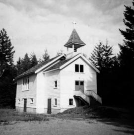
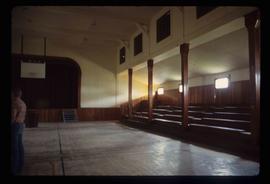
Image depicts a Catholic church at an unknown location.
Photograph depicts the catholic church at Cobble Hill on Shawnigan Lake.
Image depicts the Catholic Church in Penny, B.C.
Photograph depicts Catholic church, with rectory on its left, and First United Church behind. A wood boardwalk crosses midground, and a man can be seen riding a bicycle near church. Power lines and rough cleared land in foreground, hills and mountains in background. Handwritten annotation on recto of photograph: "Church in Rupert."
File consists of notes, clippings, and reproductions relating to Catholic churches in Prince George. File consists of material on the Sacred Heart Catholic Church at 887 Patricia Boulevard in Prince George; St. Fredricks Catholic Church in Giscome; and St. Joseph's Chapel at 1088 Gillett Street in Prince George. File predominantly includes printed photographs from The Exploration Place Museum database depicting various catholic churches in Prince George; and "St Joseph's Church" printed email from the Prince George Diocese Archives to Kent Sedgwick (17 Mar. 2010). Also includes photographs depicting a house at the address 1705 Fir Street in Prince George (2006).
Photograph depicts a cattle barn of the Douglas Lake Ranch.
Photograph depicts a cattle dock about 1/4 mile west of the former site of the Haney CPR depot. To the left and west of the dock is a meat processing plant which used to use the dock but does not anymore. The view is looking northeast.
Photograph depicts cows and calves walking on gravel beside paved road. Field and tree-covered hills can be seen in background. Handwritten annotation on recto of mounted slide reads: "Spring in Lejak [sic]".
Photograph depicts a cattle shed located 3 miles east of Pavilion Lake, which is 15 miles northeast of Lillooet. It may have been a settler's cabin at one time.
Photograph depicts a cattle shelter/ barn at the head of Nicola Lake, 20 miles east of Merritt, near the Douglas Lake road turnoff.
File contains slides depicting a caving group in various places in West Virgina, USA.
Image depicts Cayoosh Creek.
Image depicts Cayoosh Creek from a bridge in Cayoosh Valley.
Image depicts a bridge over Cayoosh Creek.
Image depicts a view of the scenery surrounding Cayoosh Creek.
Photograph depicts a horseback rider crossing Cayoosh Creek at a log bridge near Lillooet.
Image depicts a view of Cayoosh Valley.
Image depicts a view of Cayoosh Valley. Cayoosh Creek is visible in the bottom left corner of the image.
Image depicts Cayoosh Valley.
Image depicts a mountain side in Cayoosh Valley.
Image depicts a road in Cayoosh Valley.
Handwritten annotation on verso reads: “Summer / 80, S.F.U. + new life, first Jeans -”
Handwritten annotation on verso reads: “CBC Time”.
Photograph is one of seven images accompanied by notation on piece of paper reading: “CBC Publicity stills”. See also items 2009.6.1.399 - 2009.6.1.405.
Photograph is one of seven images accompanied by notation on piece of paper reading: “CBC Publicity stills”. See also items 2009.6.1.399 - 2009.6.1.404.
Photograph is one of seven images accompanied by notation on piece of paper reading: “CBC Publicity stills”. See also items 2009.6.1.399 - 2009.6.1.405.
Photograph is one of seven images accompanied by notation on piece of paper reading: “CBC Publicity stills”. See also items 2009.6.1.400 - 2009.6.1.405.
Photograph is one of seven images accompanied by notation on piece of paper reading: “CBC Publicity stills”. See also items 2009.6.1.399 - 2009.6.1.405.
Photograph depicts the C.C.G.S. "Vancouver" launched about two minutes previously and about 400 yards from Burrard Dry Dock in North Vancouver. The photograph was taken from the sailing dinghy "Ceiriog".
The photograph depicts the ceiling and support beam at the interior of the CN roundhouse in Prince George, BC. Reproduction of photograph from 1984.
Item is an aerial photograph of mill by a waterway.
Photograph depicts Celia M Dusseau's grave stone in the Soda Creek Cemetery.
Photograph depicts a Lafarge cement loading spur.
Image depicts an individual crouching in an old cemetery located somewhere in the coastal forest on Haida Gwaii, B.C.
Image depicts the Barkerville Cemetery.
Image depicts a cemetery at an uncertain location, possibly in Fort St. James, B.C.
Photograph depicts three men (two in uniform) in front of a military plane with the number "7632" on its side. Handwritten photo album caption below this photo reads: "OUR CENIAL CREW OF "32". It is believed this photograph was taken at the military base in Whitehorse, YT.
Royal Canadian Air ForceImage depicts the Centennial Hall in Wells, B.C.
Image depicts the interior of the Centennial Hall in Wells, B.C.
File contains slides depicting places in, around, and near Prince George, B.C.
Printed annotation on recto reads: “Central Avenue Fort George B.C. Copyright Canada June 25th 1913”. Handwritten annotation in ink on recto reads: “Hotel Fort George; Pool room; Men’s furnishing; General store; Bank Vancouver; Telephone office; Temperance House; Trust-company; Grand stand & fair grounds; Hospital; Ware house and general store.” Cancelled 1 cent Canadian stamp on verso is dated: "Fort George BC Jul 14 13". Handwritten message in ink on verso is addressed to Mr. Chas H Wilson 94 Gould St Toronto: "Fort George. B.C> Box 65, July 13/ 13. Dear Father, This is a 'bird's eye view' of our main street - ha! ha! some class alright. We live right behind the bakery lunch room on the right hand side of the picture, on 1st avenue, some people eh? Will be moving to Cassiar Ave soon. How are all the folks. Mae is writing. Peace. M."
Image depicts the Central Business District of Prince George looking north from Connaught Hill. Map coordinates 53°54'41.4"N 122°44'58.5"W