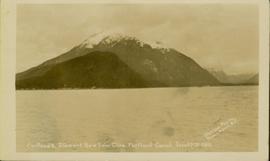
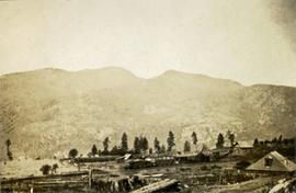
Photograph depicts Pine Creek winding through forest and hills. Altin Lake and mountains in background. Handwritten annotation on recto of photograph: "Atlin: Looking down lower Pine Ck, westerly towards Atlin, Atlin Lk, & the Atlin Mts. (part of Coast Range)."
Image depicts a view of Pine Pass.
Image depicts a view of what is possibly the Pine Pass located near the Murray Ridge.
Image depicts an unidentified individual standing near a drop-off in the Pine Pass between Alberta and British Columbia. The sign behind the individual reads: "Pine Pass - 2,868 FT. Here the great barrier of the Rock Mountains is breached by the lowest highway pass. Once the remote route of the trapper, it now links the commerce of the north and markets of the south. The John Hart Highway was completed in 1952 and followed by the P.G.E. in 1958. Gas and oil lines also take advantage of this convenient natural feature."
File contains slides depicting places in or near Pine Pass and along the Peace River.
Image depicts what is either the Peace or Kiskatinaw River in Pine Valley, B.C.
Image depicts the mostly frozen Place Creek Falls.
Image depicts the Place Glacier.
Image depicts two unknown individuals at the Place Glacier.
Image depicts the Place Glacier. There are two unknown individuals present.
Image depicts the Place Glacier.
Image depicts the Place Glacier. There are two unknown individuals present.
Image depicts an unknown individual at the Place Glacier.
Photograph features a steep cliff across water, rocky shore in foreground.
Handwritten annotation on verso reads: "Up the 'Big Creek' at Kincolith B.C. Rock face called 'the place of echoes' by the Indian people."
Photograph features a steep cliff across still water.
Handwritten annotation on verso reads: "Place of Scalps / Kincolith BC"
Photograph depicts an unidentified man mining in rocky area, trees and hills in background. Handwritten annotations on verso of photograph: "PLACER MINER WSHING FOR GOLD FINDLAY RIVER BC", "PHOTO WWW".
Photograph depicts two miners standing on either side of wooden sluicing trough in rocky area. Man on left pans for gold. Hills in background. Handwritten annotations on verso of photograph: "PLACER MINERS AT WORK INGINECA RIVER BC", "PHOTO WWW".
Handwritten caption above this photo reads: "Plane on Sumit Lake." Logs can be seen floating on water in foreground, as well as trees on opposite shore in background. The seaplane has the letters "CF-ATF" on its side.
This file contains operations at the plantsite:
Below is synopsis of the item level descriptions (see each item for further description)
- locations depicted at Plantsite: mill building, dry rock storage building, tailings pile, gravel pit, power house, and office.
- delivery and installation of a Caterpillar engine, welding repairs underway on a Rustin Diesel Engine in the power house, staff portrait taken by the main office building, and fibre testing
Not done to item level but integrated into subseries file: - Photographic negatives included depict milling and packaging machinery in the mill building.
- 93 slides depicting various activities and equipment at the plantsite including: dry rock storage, screens, collectors, loading trucks, bagging, pallets, tailing pile, lab work by engineers, lab equipment, fibre testing, and fibre samples.
- photographs of conveyor foundations, tailings equipment, Grizzly truck, containers from site mechanical inspection, and portable crushing plant in June 1991.
- photos of fibre samples from lab - on display
- collection of photos of 1970 Mill modification Program of April 1978
- collection of photos from 1961 and 1962 of plantsite lab and asbestos samples. file labeled "Suter - Webb VU Graph Analysis" and "Suter - Webb and Turner Comb Analysis"
- Pressure Packer modification photos done by Chapman Industries in 1986
- Powerhouse equipment from 1979
- additional 43 slides of inside the mill in June 1978. Slides were used at a board meeting.
- negatives of inside of mill
- A photo album of 162 photographs depicting various operations at the plantsite including: drill dust collector, outdoor surroundings, conveyors, and the mine site. (album was originally labelled "Cassiar Plantsite).
Photograph depicts plateau below summit between John Brown and Kitseucla creeks. Survey of 55th parallel.
Image depicts an aerial view of a plateau near the Fraser River.
Image depicts a totem pole and a playground in what appears to be a residential area somewhere on Haida Gwaii, B.C.
Photograph depicts a few scattered buildings and railway siding in the foreground, sparsely forested mountain in the background.
Three Indigenous men stand in a canoe poling their craft along a shoreline while one man sits and steers. An unidentified village is visible along the opposite shore.
Photograph depicts two persons holding long poles, standing on a canoe on the Nechako river. The water vessel appears to be very near a falls. Image is out of focus.
Photograph depicts four men standing on a canoe, loaded with supplies. Calm river water in the background, bluffs in the background.
Photograph depicts a pond with pink flamingos and a model boat that is located in Driftwood Canyon near Smithers.
Image depicts a pulp mill in Port Edward, B.C.
Photograph depicts Port Simpson in winter. Water and shoreline in foreground, hill in distance.
Handwritten photo caption below image reads: "Port Simpson".
Image depicts the North end of Portage Lake.
Image depicts the canoe group portaging to Indianpoint Lake.
Image depicts the path taken during the portage to McCleary Lake.
Image depicts Portal Lake, located near the Yellowhead Pass on the British Columbia-Alberta border, west of Jasper, A.B.
Image depicts numerous lily pads on the surface of Portal Lake, located near the Yellowhead Pass on the British Columbia-Alberta border, west of Jasper, A.B.
Photograph of a mountain on the waterfront. Annotation on recto reads: "Portland & Stewart. New Twin Cities. Portland Canal. June 17th 1910. Button Photo. Prince Rupert, BC."
File contains postcard photographs portraying life in various Northern BC Communities. Images depict buildings and streets, church structures, harbours and docks, and views of the shore from the water to name a few.
File contains postcards portraying life in Prince George, B.C. Images depict street scenes (George Street, Central Avenue, and Hamilton Avenue), government buildings, Hotels, a theatre, a baseball game, and construction of a pier.
File contains postcards portraying life in Prince Rupert, B.C. Images depict harbour scenes, street scenes (Third Avenue, Sixth Street, Central Street, and Mainstreet), airplanes, large ships, fisheries, city aerials, parades, military, a dog sled mail team, and a frozen fishing boat.
Photograph depicts a power dam near Cascade, BC.
Image depicts power lines east of the pulp mills in Prince George, B.C.
File contains slides depicting scenery at various locations.
Previous site of sawmill in Giscome, B.C. looking northwest. Map coordinates 54°04'19.7"N 122°22'04.7"W
Image depicts the Pride O' the North shopping mall in Prince Rupert, B.C.