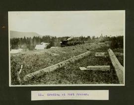
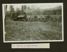
Typed caption glued to album page directly below photograph reads: "40. Grading at Fort Fraser." Photograph depicts a steam train engine pushing three cargo cars along a train track. Photographer: Dominion Stock & Bond Corporation
Typed caption glued to album page directly below photograph reads: "11. Grading at Fort Fraser." Photograph depicts railway construction workers loading dirt and rocks from the track being laid, into cargo cars attached to a steam train engine. Photographer: Dominion Stock & Bond Corporation
Photograph depicts a grader that was working on removing a sharp bend and widening Galena Bay Road.
Photograph depicts the grade of a former railway between Kaslo and New Denver, just on the east side of the summit at Retallack.
Photograph depicts a recently constructed grade that ran parallel to the BC Hydro Railway and led to a new super post. A CPR ballast train is visble on the track. Ownership of the line was vested in the BC government.
Photograph depicts a C.P.R. grade crossing warning device at Haney.
Photograph depicts a Goodyear Blimp cruising over the Centennial Museum near Sunest Beach, False Creek, Vancouver.
Photograph depicts a goodyear Blimp cruising over the Centennial Museum near Sunest Beach, False Creek, Vancouver. It came for the 1973 Abbotsford Air Show.
Photograph depicts a Goodyear airship travelling over Spanish Banks, Vancouver. It took part in the Abbotsford Air Show of 1971.
Postcard depicts the Kicking Horse Canyon. As seen from the Golden-Field Highway and Motor Road. Along the CPR line.
Image depicts the old Goat River Train Station in Goat River, B.C.
File consists of notes and reproductions relating to the Goat River railway station. Includes photographs depicting the Goat River station and a painting of the station (2009).
Image depicts the CN Railway and Station at Goat River, B.C.
Photograph taken at the Great Northern Railway connection from its terminal yards to its wharf on Vancouver Harbour or the connection with CPR. Image captured crossing Powell Street, looking southward, north of Glen Drive, Vancouver.
Photograph depicts a bridge over the Similkameen River. When track ran to Hedley, there were 3 of these bridges. All stood still at the time the photograph was captured. The other were on the lifted Keremeos to Hedley section.
Photograph depicts a rail bridge over the Similkameen River.
Photograph depicts a bridge over the Similkameen River. The branch was still in use with very little traffic. One padlocked door on each side of the bridge allows examination of trusses.
Photograph depicts the GNR (later became BN) branch from Kettle Falls to Grand Forks.
Postcard depicts Glacier Station.
Postcard depicts Glacier House, CPR, and Hermirt Range, Selkirk Mountains.
Postcard depicts Glacier House and Great Glacier House built in 1886 as one of three similar hotels, the other two being Mt. Stephen House in Field, and Fraser Canyon Hotel in North Bend. Business fell off rapidly in 1916 when tracks were relocated into a new tunnel. Buildings were demolished in 1930.
Postcard depicts Glacier House and Great Glacier.
Image depicts a street in Giscome B.C. The Giscome Store is located on the left side of the image with the church in the background. Map coordinates 54°04'18.5"N 122°21'57.7"W
Image depicts the old Giscome Train Station in Giscome, B.C. It was demolished between 1976 and 1977.
Photograph depicts people on river shore, and boat and buildings in midground. River bank in foreground, forest in background. Handwritten annotation on verso of photograph: "Giscombe Portage Fraser River", on recto: "Huble & Seaback on Fraser River."
Photograph depicts people and tree stumps in grass areas. Buildings stand on higher level in midground, forest in background. Handwritten annotation on verso of photograph: "Giscombe Portage. B.C.", on recto: "Seaback & Huble"
Image depicts a parking lot full of vehicles with the Giscome store in the background. Map coordinates 54°04'18.5"N 122°21'57.7"W
Image depicts the Giscome railway station and buildings remaining in townsite in Giscome, B.C. Map coordinates 54°04'18.0"N 122°22'04.7"W
Image depicts what is possibly the CN Railway Station and tracks located in Giscome, B.C.
Image depicts the old CN station in Giscome, B.C. Map coordinates 54°04'20.7"N 122°22'01.1"W
Image depicts the new CN station in Giscome, B.C. Map coordinates 54°04'20.7"N 122°22'01.1"W
Image depicts the old CN station in Giscome, B.C. Map coordinates 54°04'20.7"N 122°22'01.1"W
Image depicts the Giscome mill site in Giscome, B.C. The railroad tracks are in the foreground. Map coordinates 54°04'17.6"N 122°22'06.1"W
Image depicts the CN Station, with bundles of wood sitting near the tracks, in Giscome, B.C. Map coordinates 54°04'32.3"N 122°21'42.3"W
Photograph depicts a covered wooden grider bridge of the former Great Northern Railway spur that ran from north Washington state into B.C. at Keremeos, then west to Princeton. It was now only operating as far north as Keremeos.
Photograph depicts a covered grider bridge of a former railway (subsidiary of the Great Northern Railway, built in 1907-14) that formerly ran between Keremeos and Princeton, but had long since been lifted. The bridge was now used by vehicles going to a nearby ranch.
Image depicts a road near the Ginter House in Prince George, B.C.
Image depicts a private driveway, most likely leading to the Ginter Property in Prince George, B.C.
Image depicts a loading truck at the Gibraltar mine site north of Williams Lake, B.C.
Image depicts a number of workers putting in blasting powder at the Gibraltar mine site north of Williams Lake, B.C.
Image depicts an 80 tonne truck full of rocks at the Gibraltar mine site north of Williams Lake, B.C.
Image depicts the Gibraltar mine site north of Williams Lake, B.C.
Image depicts an unknown woman standing in front of a truck that either weighs 80 tonnes, or is capable of carrying that much; the slide is simply labelled "80 tons." It is located at the Gibraltar mine site.
Image depicts a helicopter in Germansen Landing, B.C.
Photograph depicts a wooden arch supporting the sagging Georgia Viaduct in Vancouver, BCThe road in the foreground is Taylor Way.
Handwritten annotation on verso of photograph reads: "George St. Prince George BC Photo. S Wrathall". Prince George Hotel and Cafe stand on left side of street in foreground, and many other buildings and businesses can be seen. Vehicles line the street, cut banks visible in background. Photograph believed to have been taken while George Street was being prepared for a new lawyer of asphalt.
Photograph depicts buildings and vehicles lining street, and hill in background. There is snow on the road and several store signs are visible. Printed annotation on recto reads: “GEORGE ST. PRINCE GEORGE B.C.”
Photograph of George Street in Prince George B.C. Cars, people, and signage are visible. Printed annotation on recto reads: “George St. Prince George B.C. 1921 R7 by Moore” There is an “X” in ink over the fire hall. Handwritten annotation in ink on verso reads: “This view is also looking north and where I have put the X is the one and only fire hall and you can see the fire engine in the street. This is the main street.”