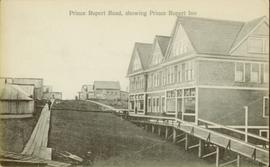
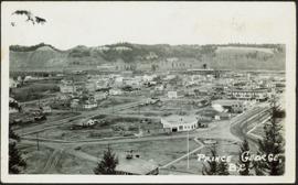
Wide angle photograph of Prince Rupert sometime during the winter. There is snow on the ground and a marge mountain range is visible in the background. Annotation on recto reads: "Prince Rupert looking East from Waterworks J.D.A Pho 5/2."
Side view of the Prince Rupert in on Prince Rupert Road. Printed annotation on recto reads: "Prince Rupert Road, showing Prince Rupert Inn."
Photograph depicts the multi-level Prince Rupert hospital with trees and shrubbery in the foreground. Annotation on recto of photograph states: "Prince Rupert Hospital W.W.W. Photo"
Overhead view of the dry dock in Prince Rupert, BC. Printed annotation on recto reads: "Prince Rupert Dry Dock."
Ground level view of the Prince Rupert court house. Printed annotation on recto reads: "Court House." Handwritten annotation on recto in blue ballpoint pen reads: "Prince Rupert BC." Handwritten annotation on verso reads: "Hi Folks. Guess you've heard the good news by now. Well we've finished our cruises for this year so its home again finally to be with Marge and Janet. Will write shortly. Love Derek." Postcard is addressed to: "Mr & Mrs J.J. Oliver Box 666 Yarmouth N.S." Verso affixed with a three cent Canadian stamp. Postmark on verso reads: "Prince Rupert BC Oct 23 130 PM 1952."
Postcard featuring a car parked outside of Prince Rupert City Hall. Handwritten annotation on verso reads: "Alex Hall, Glyn P.O., Victoria, B.C. Prince Rupert, Billy S."
Image depicts a view of what is possibly a shipping yard in Prince Rupert, B.C. The slide is labelled "superport."
Image depicts the rail yards in Prince Rupert.
Image depicts an old building on the main street of Prince Rupert, B.C. Only half of the business name is visible: "Skeena Color [sic]."
Image depicts the main street of Prince Rupert, B.C.
Image depicts numerous houses on the cliff-sides in Prince Rupert, B.C.
Image depicts numerous houses in Prince Rupert, B.C.
Image depicts several houses in Prince Rupert, B.C.
Image depicts numerous houses in Prince Rupert, B.C.
Image depicts numerous buildings and a small dock somewhere in Prince Rupert, B.C. One of the buildings is labelled "Fishermen's Supply."
Image depicts a view of the downtown core of Prince Rupert, B.C.
Image depicts the City Hall of Prince Rupert, B.C.
Image depicts the Bank of Nova Scotia located on "Besner Block" in Prince Rupert, B.C.
File contains slides depicting places in and around Prince Rupert, B.C.
Image depicts a view of Prince Rupert, B.C.
Wide angle photograph of a forested area with Prince George in the distance. Printed annotation on recto reads: "Prince George, B.C. 1924."
Photograph depicts the major buildings and streets of the town. Sloped cutbank visible across the Nechako River in background. It is believed that this photograph was taken from Connaught Hill. Handwritten annotation on verso of photograph reads: "PRINCE GEORGE, B.C."
Image depicts the Four Seasons Leisure Pool, and the Centennial Fountain in Prince George, B.C. Map coordinates 53°54'48.5"N 122°44'49.2"W
The item is a photograph depicting the rear side of the Prince George Snowmobile Club. The building was originally Buckhorn school. The building is wooden with a metal roof. Sign on the door reads, "Alarmed."
The item is a photograph depicting the side of the Prince George Snowmobile Club. The building was originally Buckhorn school. The building is wooden with a metal roof. Sign on the door reads, "New Members Welcome."
The item is a photograph depicting the front and side of the Prince George Snowmobile Club. The building was originally Buckhorn school. The building is wooden with a metal roof.
Image depicts the Prince George welcome and population sign, with a population of 71,086. Map coordinates 53°53'52.0"N 122°46'08.7"W
Image depicts the Prince George Sawmill from the Northwood Bridge.
Image depicts Prince George Sawmill taken from across the Nechako River looking southwest. Map coordinates 53°56'00.0"N 122°44'29.7"W
Image depicts an aerial view of a Prince George residential section between Highway 97, Carney Street and 10th Ave looking north. Map coordinates 53°54'54.0"N 122°46'00.4"W
The item is a contact print of photo negatives. The print includes photos of downtown Prince George ca. 1980.
The item is a photograph depicting the Prince George Railway Museum building ca. 1990. The building is white with a front deck and is situated behind a chain link fence.
The Prince George Railway & Forestry Museum Society Collection consists primarily of textual, photographic, and cartographic records related to the regional developments of the railway industry in Northern BC. A predominant portion of the collection is made up of material from the Canadian National Railway; other railways represented include the Pacific Great Eastern Railway, the British Columbia Railway (BC Rail), the Grand Trunk Pacific Railway, the Grand Trunk Railway, the Intercolonial Railway, and the Okanagan Express. Significant geographical areas covered include Prince George, the Peace River Region, Terrace, Bulkley Valley, Hazelton and Prince Rupert.
The forestry industry is represented in the collection with operational and financial records from Fyfe Lake Sawmill Ltd., which operated southwest of Prince George in the 1950s.
The collection has been organized into series according to creator, each of which also has been arranged to subseries, file and item level, where applicable. This collection consists of eight series, as follows:
1) Canadian National Railway
2) Grand Trunk Railway
3) Pacific Great Eastern Railway
4) British Columbia Railway (BC Rail)
5) Canadian Pacific Railway (CPR)
6) Intercolonial Railway
7) Fyfe Lake Sawmill ltd.
8) PGRFM
9) Photographs
The item is an interior photograph of the Prince George Public Library. Image depicts the stairwell entrance and elevator.
The item is a photograph depicting a narrow staircase from the parking level to the Prince George Public Library.
The item is a photograph depicting the exterior entrance from the parking level to the Prince George Public Library.
Image depicts the Prince George Public Library (Bob Harkins Branch). Map coordinates 53°54'43.1"N 122°44'56.4"W
Image depicts the Prince George Public Library (Bob Harkins Branch). Map coordinates 53°54'44.6"N 122°45'01.7"W
The photograph is of the power house in Prince George before 1999. The power house was built ca. 1916.
Postcard image depicts streetview looking west along 3rd Ave in Prince George, B.C. Storefronts and period automobiles are visible. Handwritten annotation on photographic negative, now visible along bottom of print image reads: "3rd Ave, Prince George B.C. Looking West. HND 41".
Photograph features the hotel on George Street, Prince George BC. Handwritten annotation on verso of photograph reads: "Xmas [1948?]", on recto: "From Mr. & Mrs. Fask Douglas." Poem on verso reads: "May Christmas Joy And all its cheer Be yours throughout A good New Year".
Image depicts the Prince George Hotel.
The item is a photograph of the Prince George Home Builders' Association Professional Building at 1705 3 Avenue, Prince George.
Collection contains photographs depicting community life in Prince George, B.C. Images depict holiday events, sports teams, government buildings, businesses (hotels, banks, retail, newspaper office), riverboats, railroad construction, fishing, a cemetery, street scenes, aerials, and landscapes. Also includes photos taken outside of the Prince George vicinity including Prairie Creek, Thomas Creek and Barkerville, B.C.
Subseries contains material created over the course of Kent Sedgwick’s involvement with the Prince George Heritage Commission between 1978 and 2006. The files include correspondence, meeting minutes, typed documents, and research materials collected for heritage projects. Some of the heritage projects Kent Sedgwick was involved in include the creation of a heritage inventory record, particularly heritage houses; developing L.C. Gunn Park; and creating interpretive signage for historic locations throughout Prince George.
Image depicts a Prince George residential area from the viewpoint of the Ginter Property.