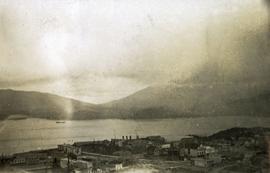
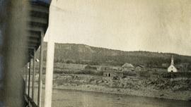
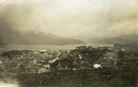
Photograph depicts a view looking down on the buildings of the city of Prince Rupert BC and beyond to the harbor and mountains in the distance.
Caption describing photograph: "Outline of Black Spruce showing dense crown form, high occurrence of multiple tops, long columnar crown with drooping branch form. Trees range between 55-70' and 10-14" DBH. Imperfectly drained clay - E.S. site. Note W Spruce vol removed by logging. Main Access Road, F.E.S. Aleza Lake."
Photograph depicts a pick hammer hanging from outcrop. Annotations on note glued to recto of photograph: "ASBESTOS"; "Outcrop of fibre bearing serpentine about centre of deposit and vertically over 300 adit on western slope." Areas of image have been labeled "A" and "B". Photo caption under printed copy of image in 1952 Annual Report: "A - indicates asbestos talus. B - indicates asbestos veinlets."
Photograph depicts exposed asbestos fibre in talus below outcrop. Handwritten annotation on verso of photograph: "Sept 1954."
Photograph depicts out buildings and Holland camp at Shawls near head of Sutherland creek "Hill Top" July.
Photograph depicts a two horse driven wagon being pulled off a snowy bank onto a gravel road amidst a forested landscape.
Valley and mountain range visible in background. Handwritten annotation on recto of photograph: "Cassiar June 1970 / Looking South to 6200 Switch-back -".
Original photographic print included in "Northern Interior Forest Experiment Station: Report of Preliminary Investigations" by Percy Barr.
Photograph depicts a muddy road in the middle of open range land with low treed hills in the distance.
Photograph depicts a large corral surrounded by open range with low hills in the distance.
Photograph depicts open range land, a river and sparsely treed hills in the distance.
Photograph depicts a double exposed photograph, a buckboard and open range land with horses and low hills in the distance.
Photograph depicts open range land with sparsely forested pine in the background.
Photograph depicts a log "snake" fence surrounded by open range land and low hills.
Photograph depicts open range land with forest in the background.
Photograph depicts open range land, stumps in the foreground and some small buildings with a river behind in the distance.
Photograph depicts grassy vegetation, open range land.
Photograph depicts a man standing on the edge of a trail looking to the treed hills in the distance.
Photograph depicts man (presumably A.H. Holland) with survey pole standing next to loaded pack horse.
Photograph depicts thickly forested area.
Photograph depicts five men with a loaded wagon, pulled by a team of two horses.
Photograph depicts four men with a loaded wagon, pulled by a team of two horses. The wagon is approaching a small bridge on a dirt road. There is a forest in the background, a small stream in the foreground.
Photograph depicts two canvas tents set up near the shore of a small lake or stream. There is a wooden structure on the opposite side of the water. Rough cleared land in the foreground, forested hills and low mountains in the background.
Photograph depicts several men standing on the river bank. Possibly A.H. Holland in center of photo.
Photograph depicts three boats on the edge of a small river. Two men attend each boat. Wild grasses with a skiff of snow in the foreground, river, forest and a low forested bluff in the background.
Item is a photograph of a copy print that has been reproduced as a slide, resulting in low photographic quality. Location of original photograph unknown.
"I originally prepared this slide in 1992 to make the point that many of those researchers who worked at Aleza lived to a ripe old age. Two of these men died in 1993, Eric Garman and Dr. Joe Falconer. Joe never quite made his 100th birthday." -- quote from the notes of Ralph Schmidt in accompanying file
Photograph depicts two men (O'Brine on left) standing in front of a log building. Handwritten note on verso reads: "Consulting engineer for Crocker 1st National Bank, San Franscisco. Examining (?) Fleuving & Downey Leases with object of taking in dredge."
Photograph depicts bulldozers, car, and fuel tanks in front of two-door garage on edge of mine area. Unidentified machinery can be seen behind garage. Mine valley crosses midground, western mountain range in background. What appears to be framing measurements are annotated on verso.
Caption describing photograph: "Old growth Douglas fir 300 yrs, 28" DBH 90' Ht. Wind shook, coarse limbed sweeping bole, heart rot, survivor of old fire. Weakly drained lacustrine deposit. Note typical of isolated distribution (single or groups occuring in Sub-Alpine zone). Very infrequent cone crops - low viability, suspect high level inbreeding. No regeneration though receptive bed. West branch, F.E.S. Aleza Lake." Harry Coates stands in the photograph for scale.
Photograph depicts a cluster of buildings including a church, a river in the foreground, rolling hills in the background.
Photograph depicts a collapsed bridge on North Fork creek.
Photograph depicts a creek with banks on either side.
File contains photographs depicting four different tours that took place at the mine, plant, and towns owned by Cassiar Asbestos Corporation Ltd. Tours include Prime Minister Pierre Trudeau's visit to Clinton Creek in 1968 and Member of Parliament Iona Campagnolo's visit to Cassiar in 1978. Photographs also depict a party of ambassadors touring Cassiar in 1970, and the dedication of a building in the Cassiar plant in the late 1970s.
File consists of notes, charts, and photographs showing forest management. May have been for a presentation by Harry Coates.
File consists of photographs of "partial willow kill - good Aspen + Fireweed control 147-009 85/87" largely depicting deforested land and young trees. Some photographs are aerial photographs.
Image depicts the Northwood pulpmill in Prince George B.C.
Image depicts the Northwood Pulpmill in Prince George, B.C. taken from above the Nechako River looking east. Map coordinates 53°56'00.0"N 122°44'29.7"W
Image depicts the Northwood pulpmill in Prince George B.C.
Photograph depicts a small coastal village in northern British Columbia.
Photograph depicts tramline in a strip cleared of trees on McDame Mountain, bucket in foreground. Handwritten annotation on recto of photograph: "#2 SECTION LOOKING NORTH". Photograph was glued to cardboard backing with the annotation: "1962".
Photograph depicts tramline in a strip cleared of trees on McDame Mountain, bucket in foreground. Handwritten annotation on recto of photograph: "1961 - 62".