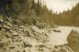
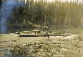
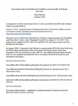
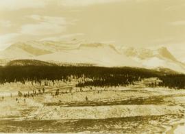
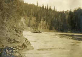
Photograph depicts several men on a long scow loaded with supplies amidst swirling deep river water.
Photograph depicts several men on the river's edge pulling on a long rope attached to a large scow downstream.
Photograph depicts a long scow on the river's edge, supplies are being loaded. There is a smoke rising from the wood stove at the center of the scow. Several men are assisting.
Photograph depicts a Grand Trunk Pacific track laying machine near John Brown creek. [55th parallel]
Front view of several men working on Grand Trunk Pacific train 218 in the winter. Handwritten annotation in pencil on verso of postcard reads: “Prince George, B.C., Dec. 1921 yard & main line.”
The photograph depicts an old Grand Trunk Pacific train station on Highway 16, West of Edmonton. The train station is white with a dark roof. Annotation on reverse side of photograph states, "on HWY #16, West of Edmonton 1991-04-16."
The photograph depicts an old Grand Trunk Pacific train station West of Entwistle on Highway 16 West. The station is white with a brown roof and brick chimney. Annotation on reverse side of photograph states, "6 km west from Entwistle on the south side of HWY 16 W, Alberta, 2001-04-17."
The group poses in front of a wood door, ivy on either side.
Handwritten annotation on verso reads: "The family at Kincolith - Summer House, 1916 / Back Row L-R: Art Macdonald, Bill Collison, Reg Collison, Jack [John] Macdonald / Front L-R: Katie Collison with Don Collison, Marion Collison, Joyce Collison, Muriel (Mimi) Collison with Colin Macdonald, Hugh Macdonald".
The group poses in front of a wood door, ivy on either side.
Handwritten annotation on verso reads: "Family group at Kincolith 1917 / Mimi [Muriel] with Colin, Bill, Katie, Jack / Art, Reg / Winnie [Marion Winnifred], Hugh, Joyce, Don".
Photograph depicts group of buildings at Grande Prairie airstrip. The foremost building has the sign "YUKON SOUTHERN" on its roof, and the tower and admin building can be seen behind. Power poles, large trucks, and other large unidentified machinery are lined up in background on right.
Royal Canadian Air ForcePhotograph depicts building with small second story attached, and a tall red and white pole in front. Signal tower and power poles in background on right, semi-trailer in background on left. A man in uniform can be seen in the far right sitting on a small staircase on wheels. Small unidentified buildings and miscellaneous shop supplies in background. Handwritten photo album caption beside this photo reads: "Grand Prairie Tower and Adm. Bldg."
Royal Canadian Air ForceImage depicts a row of houses in Granduc, near the Granduc Mine and located north of Stewart, B.C.
Image depicts a row of boarded up houses in Granduc, near the Granduc Mine and located north of Stewart, B.C.
Image depicts housing in Granduc, near the Granduc Mine and located north of Stewart, B.C.
Image depicts an example of "typical housing" in Granduc, near the Granduc Mine and located north of Stewart, B.C.
Image depicts an 80 tonne truck at a mine site somewhere in Granisle, B.C.
Image depicts numerous bags of blasting powder at a mine site somewhere in Granisle, B.C.
Image depicts a drill for blasting holes at a mine site somewhere in Granisle, B.C.
Image depicts a large, electric shovel at a mine site somewhere in Granisle, B.C.
Photograph depicts Granite Falls near the Wigwam Inn, Indian Arm, Vancouver, B.C.
Photograph depicts Granite Falls and wharf at Indian Arm, looking west from the top of the falls.
Photograph depicts a B.C. Hydro Railway locomotive switching a flat car filled with construction equipment.
Photograph depicts a B.C. Hydro locomotive switching a flat car carrying a cat crane. Looking west with Granville road bridge in the background.
Series contains photographs taken and collected by Barry McKinnon of his family and colleagues. Also includes a small number of art prints and postcards.
The item is a photograph depicting a field with flowers at Grassie Plains. A lake can be seen in the background. Annotation on reverse side of photograph states, "Grassie Plains P Byle 2003."
The item is a photograph depicting a graveyard with flowers at Grassie Plains. Annotation on reverse side of photograph states, "Grassie Plains."
The item is a photograph depicting a graveyard with flowers at Grassie Plains.
A comparative study of grassland soils at 3 sites in northwestern BC and southern Yukon was published as:
Sanborn, P. 2010. Topographically controlled grassland soils in the Boreal Cordillera ecozone, northwestern Canada. Canadian Journal of Soil Science 90: 89-101. https://doi.org/10.4141/CJSS09048
This grew out of a field trip with Ministry of Forests range personnel to the Stikine and Tuya River valleys, near Telegraph Creek BC on August 27-28, 2007. (Two pedons were sampled in 2007, BC07-03 and BC07-04, but those results were not included in the paper.)
In August 2008, Dr. Paul Sanborn returned to the Stikine to sample pedon BC08-06, after field work in Yukon which collected the other two pedons used in the paper, from near Carmacks (Y08-39) and Kluane Lake (Y08-41). (An additional pedon from Kluane, Y08-43, was sampled and analyzed, but it was from a forested site and was not included in the paper.)
File consists of thin section micrograph images from the Boreal Cordilleran grassland soils study (2007 & 2008).
Photograph depicts a landscape shot of a grassy area with fruit-bearing trees in the background.
Image depicts Grassy Plains, B.C.
Photograph depicts a grassy plateau with a tree in the foreground leading to forested foothills and rising to rocky mountain slopes.
Photograph depicts a grassy, snow-covered plateau leading to forested foothills and rising to rocky mountain slopes.
Photograph depicts a grassy plateau leading to forested foothills and rising to rocky mountain slopes.
Photograph depicts a grassy plateau leading to forested foothills and rising rocky mountain slopes.
Photograph depicts a grassy plateau leading to forested foothills and rising to rocky mountain slopes.
Photograph depicts a grave, covered in flowers and surrounded by snow. The grave is marked with what appears to be cement grave markers bordering the burial. The location of the grave is unknown.
Image depicts the grave of Frank Russell "Russ" Baker in Fort St. James, B.C.
Image depicts the grave of W.L. Meason in the upper Fraser Canyon.
Photograph depicts a grave in the churchyard of Murray Church in Nicola, near Merritt. The church was built in 1876, which makes it one of the oldest churches in the interior of B.C. The gravestone shows a death in 1882, of a son aged 14.
Photograph depicts grave marker which reads "ALLAN McCALLUM / 1906 - 1981 / RAISED NEAR HERE AS A SON OF A PIONEER FAMILY, HE WISHED TO BE RETURNED TO THIS PLACE HE LOVED ABOVE ALL OTHERS AND WHERE HE FELT SO AT PEACE."
Image depicts numerous grave markers at an uncertain location.
Image depicts the grave of John A. Cameron at Barkerville, B.C.
Image depicts the grave of John A. Fraser in Barkerville, B.C.