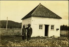
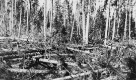
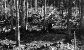
Photographer's photo number R882. Caption on back of photograph states: "Photo no. 1. Subplot 13. X-9696. Exp. Plot 160. See sketch of plot for location of photo."
EP 660 was a conventional silvicultural trial established in 1967 which involved single species plantings of lodgepole pine (Pl), white spruce (Sw), and Douglas-fir (Fd) at different spacings. Three installations were established in the Prince George - Vanderhoof area: Buckhorn Ridge, Bobtail Road, and Chilco Creek.
General details on EP 660 are given by:
Coopersmith, D., M. McLellan, and J. Stork. 1997a. Experimental Project 660 overview of three experimental installations – a 30-year progress report. B.C. Min. For., Prince George For. Reg., Res. Note #PG-12.
Details on the Buckhorn installation are given by:
Coopersmith, D., M. McLellan, and J. Stork. 1997b. Experimental Project 660 30-year progress report: Buckhorn Installation. B.C. Min. For., Prince George For. Reg., Res. Note #PG-12-1.
File contains 8 slides from 2 rolls, taken August 1997:
Roll 1 - Buckhorn Ridge:
- Slide 31 – Fd (2 x 2 m) – stand view
- Slide 32 – Fd (2 x 2 m) – forest floor view
- Slide 33 – Pl (2x 2 m) – stand view
- Slide 34 – Pl (2 x 2 m) – forest floor view
Roll 2 – Bobtail Road: - Slide 20 – Pl (2 x 2 m) – east plot, stand view
- Slide 21 – Pl (2 x 2 m) – east plot, stand view
- Slide 22 – Fd (2 x 2 m) – east plot, stand view
- Slide 23 – Sw (2 x 2 m) – stand view
Subseries consists of photographic material pertaining to early geological exploration and planning of the mine sites, plant sites and town sites of both Cassiar, B.C. and later Clinton Creek, Y.T. This subseries also includes photographic material capturing mining locations not owned by Cassiar Asbestos Corporation for what is believed to be corporate research and development purposes.
Photographs within this file pertain to the early exploration of northern British Columbia.
This BC Provincial Archives photograph reproduction depicts five men carving a canoe close to Finlay River on September 18, 1913.
Item is a photograph of the explosion which opened up the diversion route for the Peace River during construction of the W.A.C. Bennett Dam.
File contains portraits and sample photographs of exposed asbestos fibre: in veins of rock outcrops, and loose in talus on McDame Mountain (location of Cassiar mine). Some photographs were printed in Cassiar's Annual Reports, with labels and descriptions.
Photograph depicts the pre-renovation exterior of the Kitkatla school.
Photograph depicts the pre-renovation exterior of the Kitkatla school with playing children.
Photograph depicts the exterior of a newly renovated Kitkatla school, designed by North Vancouver architect Ib G. Hansen.
Photograph depicts the exterior of the second floor entryway of the newly renovated Kitkatla school, designed by North Vancouver architect Ib G. Hansen.
Façade of the Arch-cathedral in St. John's in Warsaw, Poland.
Photograph taken during European Sports Tour with Team Canada.
Photograph depicts a face at the base of a totem pole supported by ropes at Skidegate museum, Queen Charlotte Islands.
Typed annotation on recto: "The Factor's Home H.B.Co. Post Fort St. James, Stuart Lake, B.C." Man and woman stand formally attired in front of small, square, white house. Log fence and tree-covered hillside in background.
Photograph depicts a Fairmont speeder, lettered KVR, owned by Kettle Valley Steam Railway.
Photograph depicts equipment that says "Fairmont Tamper," but Davies states that it must be a ballast reclaimer and screener.
Photograph depicts the control panel of a Fairmont 2 man track car. Belt transmission.
Photograph depicts Shannon Falls near Squamish, which was formerly named Fairy Falls.
Image depicts some fallen trees at Island Cache.
No caption on back of photograph to glean further information. Title provided based on contextual information from related photographs and documents. Photograph may depict windfall on Plot 13 similar to the previous photograph 2007.1.45.49.38.
Photograph depicts a totem pole supported by smaller poles, and a second totem pole standing straight in background. Beach in foreground, fence and hills in distance.
Handwritten annotation on verso reads: "Falling greatness, Chapt. XXI No. 5, A Chief's Totem Pole inclined to fall. [Gitaix?] Encampment, Nass River. Five illustration for Chapt. XXI."
No caption provided with photograph. Photograph depicts a fallowed field at Red Rock Nursery.
Photograph depicts the north bank of False Creek in Vancouver, B.C. The photograph was taken from the Cambie Bridge, with a view looking west.
Photograph depicts men, women, and children sitting on deck near stern of what appears to be a small riverboat. A man wearing overalls stands on side deck. Water in foreground, trees on hillside in background.
Three woman, young girl, and young boy stand and sit in entry way of house with tiled roof. Sidewalk, front lawn, and hedges in foreground. Photograph believed to have been taken in Los Angeles, California.
Photograph depicts men, women, and infant seated in the Canfor Theatre at the University of Northern British Columbia in Prince George, B.C. Unidentified individuals sit in seats in background. Accompanying note from Maureen Faulkner: "Next row down is R. [Roseanne Moran] & the Kennedy's, I move to join her next to walkway." Photo taken on the day Bridget Moran received an Honourary Law Degree.
Photograph depicts men, women, and infant sitting in crowded Canfor Theatre at the University of Northern British Columbia in Prince George, B.C. Accompanying note from Maureen Faulkner: "Your family. now behind R [Roseanne Moran] + me. look on with pride & interest." Photo taken on the day Bridget Moran received an Honourary Law Degree.
Photograph depicts a woman, man and young girl believed to be A. K. Bourchier's niece Jean, standing on front balcony of house.
The group stands and sits with dog on front steps of house with veranda. Handwritten annotation on recto of photograph: "The whole 'Blamed Family'" (see also item 2009.5.2.267 for reference to Blamey family). Handwritten annotation on recto of duplicate: "All of us the same day, across the top Shirley Ed (Dorothy's husband) & Dorothy. Taken in front of their home."
Two couples stand by front steps of house with veranda. Handwritten annotation on recto of photograph: " Ed, Dorothy, Shirley, Rich. When Rich was home this summer."
File consists of family photographs of Bertha Schenk (Wood) and her husband, James Wood.
Five woman and one young girl pose on grass in front of palm trees.
Series consists of records reflecting the activities of the Dezell and Rustad families. Series include mayoral records from Bea and Garvin Dezell when Garvin served as Mayor of Prince George. Series includes materials celebrating Bea Dezell's life created by her family. Series also includes fundraising efforts for the Northern Medical Programs Trust. Finally, series includes a collection of "spruce" dollars and commemorative coins.
This item is a photograph of the Fane Building in downtown Prince George. "For Lease Office Space" sign in one of the windows.
This item is a photograph of the Fane Building in downtown Prince George.
This item is a photograph of the Fane Building in downtown Prince George. The Telus building can be seen in the background.
File consists of notes, clippings, and reproductions relating to Fannie Kinney who was a school teacher from 1944 to 1966 at the Elementary School in South Fort George. Includes: "Heritage Trail Sign - Fannie Kinney" typescript letter to Matte DeNys Public Works from Kent Sedgwick (27 July 1988); and "Fanny Kinney" typescript transcript off Pioneer Tape Cassette 16-A from the Prince George Public Library (ca. 1970). Includes photographs depicting Fannie Kinney's house and a sign erected to honour her in the community (2003).
Image depicts a farm at an uncertain location.
Image depicts a farm likely in Woodpecker, B.C.
Image depicts a farm on the west side of the Fraser, south of Quesnel, B.C.
Image depicts what appears to be a farm at an uncertain location.
Image depicts a farm at an uncertain location; possibly somewhere in the McGregor Valley.
Image depicts a farm at an uncertain location.