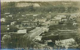
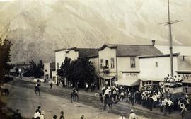
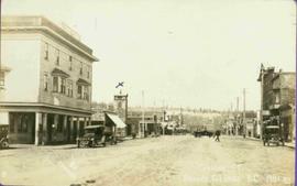
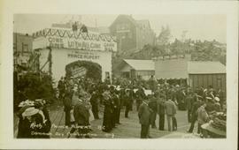
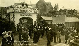
Photograph of George Street in Prince George B.C. Cars, people, and signage are visible. Printed annotation on recto reads: “George St. Prince George B.C. 1921 R7 by Moore” There is an “X” in ink over the fire hall. Handwritten annotation in ink on verso reads: “This view is also looking north and where I have put the X is the one and only fire hall and you can see the fire engine in the street. This is the main street.”
Printed annotation on recto reads: “George St. Prince George B.C.”, handwritten in pencil on verso reads: “CA. 1915”
File consists of clippings, notes, and reproductions relating to George John Hammond, the CEO of the Natural Resources Security Company who bought and promoted nine district lots in early Fort George. Includes: "Early papers index" handwritten notes by Kent Sedgwick (2005) and "Geo. J. Hammond" handwritten notes by Kent Sedgwick (2005). Also includes photographs depicting a house at the address 321 North Moffat (2005).
Photographs within this file document natural and artificial features across the landscape of Northern British Columbia. This landscape also includes the physical, built, urban and industrial landscapes; topography; site plans; boundaries, districts, reserves, parks, sanctuaries, towns, villages and cities, etc.
Photograph depicts young girl standing on front deck of "WANAMAKER'S GENERAL MERCHANDISE." Car visible on left, gas pump in front. Trees and neighbouring house visible in background. Handwritten annotation on recto of photograph: "ATLIN."
File includes six aggregations of photographs which have been assembled in this file in order to maintain the integrity of each group by keeping the photos arranged together, though each group features operations pertaining to multiple files in this subseries. Includes groups featuring photos from 1961, 1965 1971, a helicopter trip, a community album, and a workplace album. Photographs depict images pertaining to the following operations at Cassiar, B.C.: mining, milling, maintenance, labratory tests, and tramline and town operations. Images featuring operations of the company town include the grocery store, bank, churches, school, library, lounge, pool, theater, community center, outdoor recreation, hospital, dentist, cafeteria, bus route, residences, air strip, firehall, laundromat, park, police, and newspaper.
Subseries consists of photographic material pertaining to the following subject areas: mine operations; plant operations;labour strike 1970s images; townsite operations of the company towns of Cassiar and Clinton Creek (including community activities associated therein and townsite development); as well as, images of mines not owned by Cassiar Asbestos Corporation, but which are believed to have been used for operational research purposes.
Image depicts a gathering of people for an uncertain event at an uncertain location, possibly in Lillooet, B.C. A few tents are set up in the picture.
Photograph depicts a group of men, women, and children walking across beach towards water. Buildings visible on shore in left background.
Handwritten annotation on verso reads: "Funeral party - en route to boat Metlakatla BC (Taking body over to Grave Island".
Handwritten annotation on recto of photograph: "Front St. Hazelton in Winter. 12 J.W. [...]" Tree line, field, and hills in background. Handwritten annotation on verso of photograph: "Miss. Nellie [Nelville] G. Caranaugh".
File consists of notes and reproductions relating to the local history project done by June Chamberland and her book "From Broadaxe to Clay Chinking: Stories about the Pioneers in and around the Prince George area" winning the Jeanne Clarke history award. The book includes a chapter "Introduction to Early Agricultural Settlement in the Prince George Area" by Kent Sedgwick. Includes a CD titled "June photos" containing photographs depicting interviewees of the project (2003).
Photograph depicts two unidentified woman standing in front of tall plant in mall. Photo believed to have been taken in Newton, B.C.
Handwritten caption beside this photo reads: "Fred Youngstrom & Kitchen Staff. 1946." Photograph depicts Fred standing to right of three woman, a young girl, and a dog. The group is standing on the snow-covered front steps of a (kitchen?) building, lumber pile on far right. A large metal triangle is hanging behind Fred. It is believed that this photograph was taken at the camp at Summit Lake B.C. (see item 2005.3.57).
Handwritten caption above this photo reads: "Fred Youngstrom in [church shirt?]" Photograph depicts two men (Fred on left) standing on snow-covered road in front of car with a British Columbia license plate "93-650". A wood pile and long building with porch can be seen in background in front of forest trees. It is believed that this photo was taken at the camp in Summit Lake, B.C. (see item 2005.3.57).
The Fred Jeffery Collection consists of three photograph albums comprising a total of 303 b&w photographs all dating from ca.1924-1933. The subject matter of these images consist primarily of the fishing industry, river & landscapes, salmon cannery images (housing, people, workers, machinery, boats) on the Nass River and North Pacific Coast. Notable are the photographs depicting indigenous (Nisga'a) people and places and Chinese and Japanese cannery workers. Identified canneries featured in these photographs include: Mill Bay Cannery, Namu Cannery, Klemtu Cannery, Shushartie Bay Cannery, Balmoral Cannery, North Pacific Cannery, Nass Harbour Cannery, Port Essington Cannery, Kitwanga Cannery, Port Nelson Cannery, Alert Bay Cannery, Dominion Cannery and ABC Co. Cannery. Photographs also include images of the Canadian Pacific Railway in both Vancouver and Sicamous, BC., as well as, images of the Legislative Assembly buildings in Victoria, the 1924 Special Service Squadron ships in Vancouver, early construction of the University of British Columbia in Vancouver, and town overviews of Yokohama, Japan (pre WWII).
Jeffery, FredFile consists of notes, clippings, and reproductions relating to the Fraser-Fort George Museum Society Museum Publications committee consisting of Kent Sedgwick, Keith Gordon, and Denise McCallum and publishing local histories through the museum. The file primarily consists of material regarding the re-publication of "History of Prince George" by Rev. F.E. Runnalls. Includes photographs titled "Runnall's Book" and depicting historical Prince George and Rev. Runnalls.
Two unidentified men stand in background.
Handwritten annotations on verso read: “Oct 2/1992, Faculty of Management, University of Calgary, Frank King and Iona Campagnolo,” and “from Calgary ’88 Friends”.
Men stand wearing vests and ties in doorway framed in corner of building with the sign: "R. CUNNINGHAM LTD. GENERAL MERCHANDISE." Various other advertisements hang from doorway. Man on left believed to be transport driver also featured in items 2009.5.1.80 & 2009.5.1.81. Handwritten annotation on recto of photograph: "Hazelton, B.C. 1910".
Six men stand on boardwalk in front of theatre.
Photograph depicts the early settlement of Fort George. The buildings to the left of the fence are believed to be owned by the Hudson's Bay Company. The land to the right of the fence belonged to the Fort George Reserve, the home of today's Lheidli T'enneh Band who relocated to a reserve at Shelley when this reserve was sold in 1912. Handwritten annotation on verso and recto of this photograph reads: "Fort George from opposite side of Fraser River".
Photograph depicts lane in front of tent buildings flooded with water, forest trees in background. Photograph taken from canoe, portion of canoe visible in foreground. It is believed that this photograph may depict the Island Cache in flood, at Prince George, BC.
Photograph depicts lane in front of tent buildings flooded with water. Tree in midground, forest trees in background. A man can be seen between first and second row of tent buildings. Photograph taken from canoe, portion of canoe visible in right foreground. It is believed that this photograph may depict the Island Cache in flood, at Prince George, BC.
Photograph depicts two men in a row boat, one rowing and one holding a peugh (J.J. Claxton) and watching the catch being reeled in on the fishing pole of another man wearing a hospital gown. A small boy on the deck watches. Handwritten annotation in pencil on verso reads: “JJC x”
Photograph of a large crowd gathered in front of a Grand Trunk Pacific train. Residential buildings atop a hill are visible in the background. Annotation on recto reads: "First Train Leaving Prince Rupert June 14 1911"
Photograph of a mustachioed man perched atop a cart load of lumber hitched to a team of horses. Annotation on recto reads: "First Team Hitched Up at Prince Rupert May 1908."
Rocky shoreline featuring a small dwelling, totem pole, net rack, canoes pulled up to shore, barrels and boxes and a tent.
Handwritten annotation in pencil on verso reads: “Kunhalas [sic] at entrance to C--- Harbour”.
Photograph depicts a man and woman standing on steps to a round tower in fenced area. Roofs of other buildings can be seen below on right; water and shore visible in background.
Printed on image: "Indian Jail, Metlatkla".
File consists of notes, clippings, and reproductions relating to federal government buildings in Prince George. Includes: "Fw: Info - Prince George Former Post Office - 1294 3rd Avenue" printed email from Trelle Morrow to Kent Sedgwick (27 May 2011); "City of Prince George" typescript letter to Noel O'Beirne from Kent Sedgwick (13 Nov. 1991); "Possible users for federal government building 3rd Avenue/Quebec Street" typescript letter to Alderman Becott from Kent Sedgwick (10 Oct. 1989); "City of Prince George" typescript letter to Dr. Colin Campbell, Director of Heritage Conservation Branch from Kent Sedgwick (5 May 1989); "RE: Municipal Heritage Designation of Federal Government Building" typed letter from Ian Whitbread to Kent Sedgwick (28 Mar. 1991); "Bylaw No. 5538" typescript document from the City of Prince George (3 Apr. 1991); "Public Notice 'Heritage Designation Bylaw No. 5538, 1990'" typescript document from B.C. Williams, City Clerk (1990); "Intersect" typed letter to Kent Sedgwick from Kathy Antonyk (14 Mar. 1994); and "Heritage Conservation in your community..". pamphlet from the Heritage Advisory Committee (1994). Also includes a photograph depicting the old Post Office in Prince George (1990).
Image depicts a street, possibly in Kamloops, which has been closed for a Sunday morning Farmer's Market.
Series consists of records reflecting the activities of the Dezell and Rustad families. Series include mayoral records from Bea and Garvin Dezell when Garvin served as Mayor of Prince George. Series includes materials celebrating Bea Dezell's life created by her family. Series also includes fundraising efforts for the Northern Medical Programs Trust. Finally, series includes a collection of "spruce" dollars and commemorative coins.
Typed annotation on recto: "The Factor's Home H.B.Co. Post Fort St. James, Stuart Lake, B.C." Man and woman stand formally attired in front of small, square, white house. Log fence and tree-covered hillside in background.
Photograph depicts a group of nine men holding a flag and banner that states: "The Epworth League of The Methodist Church of Canada." Annotation on verso of photograph states: "Epworth League Officers Port Simpson This is a fair sample of the "shots" I made"
Sign in foreground reads: “Stop Bull Shitting, [Phoney (crossed out)] Ioney”.
Handwritten annotation on verso reads: “The Kitimat Oil Port Environmental Lobby, didn’t believe I killed it. I did!”
Semi-visible sign reads: “Supertanks - Pipelines S.O.S.”
Photograph depicts crowd with individuals holding protest signs.
Photograph of several vehicles parked along a road. A large crowd is visible gathering in the background. Printed annotation on recto reads: "Elks Flag Day, McBride, B.C." Handwritten annotation on verso reads: "Jan. 5th 1945. Dear Dad, Am working in a lumber camp, advised by Prof. Johnson and Prof Casey. Altitude about 2,300. Think I will like it, if they don't make me work to[sic] heavy. the Climate and the grub is swell. Otherwise not so hot. Bye for now. Love Will." Postcard is addressed: "To: Mr. A.W. Hockin Big Valley, Alberta. From. W. Hockin c/o E.U. Lamming McBride, B.C."
Four women sit in foreground at a porch partially covered with foliage.
Handwritten annotations on verso read: "Honoured elders of porch of Mission House at Kincolith, Nass River"; "sun set or legend of the past".
Handwritten annotation on verso reads: "A very old Tsimpsion women - said to be over 110 yrs old."
Photograph depicts town buildings on opposite shore. Beach and dock can be seen in foreground.
Handwritten annotation on verso reads: "Chapter XXII, No 1. Eastern Section of Port Simpson as christianized."
Photograph depicts unidentified individual and cars on street in foreground, snow banks, trees, and power poles on either side. Buildings can be seen on far right, mountains visible in background. Handwritten annotation on recto of photograph: "townsite Looking East".
Subseries consists of material collected by Kent Sedgwick for research regarding the communities along the East Line of the Grand Trunk Pacific Railway in Central British Columbia, particularly between Prince George and McBride. These communities and locations include, among others, Shelley, Willow River, Sinclair Mills, Longworth, Dunster, Tete Jaune, Valemount, Mount Robson, and the Yellowhead Pass. Research on these communities was conducted during Kent Sedgwick's involvement in the UNBC-led Upper Fraser Historical Geography Project. The files primarily consist of research notes, audio and transcripts of oral interviews, and photographs of the East Line communities.
Row of buildings with path and poles. Rough cleared land in foreground, men visible in far left background.
File consists of mounted and clipped together panoramic photographs of downtown Prince George.
Crowd is gathered for Dominion Day Parade. Decorated float can be seen in centre of street, and Hotel Prince Rupert stands in background. Printed annotation on recto reads: “Dominion Day Prince Rupert 1914 Photo W.W.W.” Handwritten message in ink on verso is addressed to “Mr. S. Smart 2550 Blackwood St Victoria B.C.”
Photograph depicts an event on Lillooet Main Street with spectator crowds. The Union Jack and Canadian Red Ensign flags suggest this may be a Dominion Day event. The Lillooet community put on large, multi-day Dominion Day events between 1912 and 1916 with many planned activities. The particular activity depicted in this photograph may be a horse race or rodeo-type event. Main Street businesses visible include the Lillooet Restaurant, the Lillooet Pool Hall, and the "OK" Baths.
Photograph depicts an event on Lillooet Main Street with spectator crowds. The Union Jack and Canadian Red Ensign flags suggest this may be a Dominion Day event. The Lillooet community put on large, multi-day Dominion Day events between 1912 and 1916 with many planned activities. The particular activity depicted in this photograph appears to be a horse race event. Main Street businesses visible include the Lillooet Restaurant and the "C.A. Phair General Merchant" store.
Large crowd gathered on the street in downtown Prince Rupert. Decorations are hung around and town, and a lavishly decorated arch in the background reads "Come One Let 'Em All Come Come All. Welcome to Prince Rupert."
Photograph of a large crowd in formal wear gathered on a slope. Some spectators can be seen perched atop extremely high poles. Annotation on recto reads: "The Crowd at Prince Rupert's Dominion Day Celebration 1909. Allen Photo 1-7-09."
Large crowd gathered on the street in downtown Prince Rupert around a lavishly decorated arch which reads "Come One Let 'Em All Come Come All. Welcome to Prince Rupert." Annotation on recto reads: "Arch Prince Rupert, BC. Dominion Day Celebration 1909. Allen Photo."