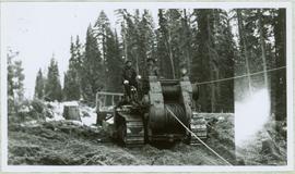
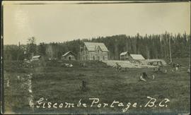
Print preview Close

Showing 4038 results

Archival description
2005.3.31 · Item · [ca. 1945]
Part of John Hart Highway Photograph Collection

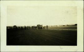
Handwritten caption beside this photo reads: "Fred Youngstron [sic?]" "Foreman spotting for operator." Photograph depicts one man seated on D8 Caterpillar operating a haulback rig, and a second man (Fred?) standing behind him on Caterpillar. Image quality is poor and faces are not visible. Dirt and debris in foreground, forest in background. It is believed this rig is operating in a long-line skidding system.

2005.3.32 · Item · [ca. 1945]
Part of John Hart Highway Photograph Collection

Handwritten caption above this photo reads: "Fred Youngstron[sic?]" "Foreman spotting for operator." Photograph depicts one man (Fred?) seated on D8 Caterpillar operating a haulback rig, and a second man standing beside him on the Caterpillar. Dirt and debris in foreground, forest in background. It is believed this rig is operating in a long-line skidding system.

2013.6.36.1.028.28 · Item · 18 Sept. 1970
Part of David Davies Railway Collection

Photograph depicts a freight shed at the Nelson CPR depot. There is a terminal spur on the south side of the shed and road trucks on the north side. The road side of the main depot building can be seen in the left rear of the photo. The view is facing east.

2013.6.36.1.028.32 · Item · Aug. 1983
Part of David Davies Railway Collection

Photograph depicts a westbound freight train near Moyie on the CPR line. This is at about mile 13 on the Nelson Subdivision, which spans 137.8 miles from Cranbrook to Nelson. The line here is adjacent to the Moyie Lake Provincial Campsite. The train is about to enter the portal of a small tunnel that bores through the rocky headland of the lake.

2013.6.36.1.021.07 · Item · [24 May 1973]
Part of David Davies Railway Collection

Photograph depicts a Princeton bound freight train passing the old CPR station at Brookmere, located at 30 miles south of Merritt. The freight is passing the summit between Spences Bridge and Princeton. It consisted of 4 locomotives and 38 cars (mainly chip cars). At one time Brookmere was a thriving substation divisional point in the middle of nowhere. Now it is a passing loop to hold 64 cars.

2013.6.36.1.021.06 · Item · [24 May 1973]
Part of David Davies Railway Collection

Photograph depicts a southbound freight train passing the old CPR station at Brookmere, located at mile 108.7 on and from the Princeton Subdivision. The freight passed at about 20 mph, after a long grind uphill from Merritt. It consisted of 4 locomotives, 38 cars, and a caboose. Regular freights only pass twice a week, one each on Tuesday and Thursday. It is passing the derelict water tank at the north end of the yards, which are at the summit of this subdivision.

2013.6.36.1.005.63 · Item · Oct. 1965
Part of David Davies Railway Collection

Photograph depicts a Gaar Scott traction engine in working order, steamed twice a year at least. It was built by the M. Rumely Co. in Richmond, Indiana, U.S. The engine is a #16541, has 25 horse power, and 2 cylinders. It was photographed at Texaco Station in Nanton, Alberta. It was owned by Jack burrows of Nanton.

2013.6.36.1.005.66 · Item · Oct. 1965
Part of David Davies Railway Collection

Photograph depicts the rear view of the Gaar Scott traction engine parked at Texcoc Station in Nanton, Alberta. The rear wheels have a 2'9" tread. It was used on farms for haulage, threshing, chaff cutting etc., but not plowing.

Garbage Burner
2013.6.36.1.032.15 · Item · [26 May 1968]
Part of David Davies Railway Collection

Photograph depicts a garbage burner in the Esquimalt & Nanaimo Railway yards in Victoira. This photograph is taken just south of Victoria West Park.

2013.6.36.1.082.16 · Item · 9 Oct. 1971
Part of David Davies Railway Collection

Photograph depicts gas pumps that were adjacent to the Acton Kilby General Store that was operated by Mr. Acton Kilby, aged 81. He is visible in the shadows towards the left of the photograph and the left pump. Mr. Kilby's father acquired the store in 1902. The store was near historical Harrison Mills.

2006.20.12.41 · Item · [ca. 1940]
Part of Northern BC Archives Historical Photograph Collection

Handwritten photo album caption below this photo reads: "Gathering up the pieces [re. plane crash, item 2006.20.12.42]." Photograph depicts two trucks and a large group of men standing in airstrip believed to be at Whitehorse. Group of various buildings visible in background on right.

Royal Canadian Air Force
General Motors switcher
2013.6.36.1.153.02 · Item · [June 1996]
Part of David Davies Railway Collection

Photograph taken at the Northwood Pulp and Timber Ltd, Prince George. Visible is a General Motors switcher, built in 1959. Aqcuired in 1981. On private Northwood trackage with the mill in the background.

General Motors switcher
2013.6.36.1.153.05 · Item · [June 1996]
Part of David Davies Railway Collection

Photograph depicts a switcher running towards a CN interchange. Just left the Fraser River bridge. All private and owned by Northwood Pulp and Timber Ltd.

General Store in Atlin, BC
2009.5.2.32 · Item · [ca. 1935]
Part of Taylor-Baxter Family Photograph Collection

Photograph depicts young girl standing on front deck of "WANAMAKER'S GENERAL MERCHANDISE." Car visible on left, gas pump in front. Trees and neighbouring house visible in background. Handwritten annotation on recto of photograph: "ATLIN."

2011.12.02 · Item · ca. 1950
Part of Giscome, BC Historical Photograph collection

Photo depicts a street perspective of George St., in Prince George, BC, ca. 1950. Annotation recto reads: "George St. Prince George BC Photo by J Wrathall." Handwritten annotation in pen on verso of postcard reads: “This is the Hastings Street of Prince George. This & 3rd Streets are the main thoroughfares.”

2011.3.2.17 · Item · 1921
Part of North Coast & Central BC Postcard Collection

Photograph of George Street in Prince George B.C. Cars, people, and signage are visible. Printed annotation on recto reads: “George St. Prince George B.C. 1921 R7 by Moore” There is an “X” in ink over the fire hall. Handwritten annotation in ink on verso reads: “This view is also looking north and where I have put the X is the one and only fire hall and you can see the fire engine in the street. This is the main street.”

2009.5.3.82 · Item · [ca. 1950]
Part of Taylor-Baxter Family Photograph Collection

Handwritten annotation on verso of photograph reads: "George St. Prince George BC Photo. S Wrathall". Prince George Hotel and Cafe stand on left side of street in foreground, and many other buildings and businesses can be seen. Vehicles line the street, cut banks visible in background. Photograph believed to have been taken while George Street was being prepared for a new lawyer of asphalt.

Gibraltar - 80 Tonne Truck
2012.13.1.50.094 · Item · [1978?]
Part of J. Kent Sedgwick fonds

Image depicts an unknown woman standing in front of a truck that either weighs 80 tonnes, or is capable of carrying that much; the slide is simply labelled "80 tons." It is located at the Gibraltar mine site.

Girder bridge, Keremeos
2013.6.36.1.070.08 · Item · [July 1967]
Part of David Davies Railway Collection

Photograph depicts a covered wooden grider bridge of the former Great Northern Railway spur that ran from north Washington state into B.C. at Keremeos, then west to Princeton. It was now only operating as far north as Keremeos.

Girder bridge, Keremeos
2013.6.36.1.070.07 · Item · [July 1967]
Part of David Davies Railway Collection

Photograph depicts a covered grider bridge of a former railway (subsidiary of the Great Northern Railway, built in 1907-14) that formerly ran between Keremeos and Princeton, but had long since been lifted. The bridge was now used by vehicles going to a nearby ranch.

2012.13.1.87.087 · Item · [between 1975 and 1995]
Part of J. Kent Sedgwick fonds

Image depicts the Giscome mill site in Giscome, B.C. The railroad tracks are in the foreground. Map coordinates 54°04'17.6"N 122°22'06.1"W

Giscome CN Station
2012.13.1.87.161 · Item · [between 1975 and 1995]
Part of J. Kent Sedgwick fonds

Image depicts the old CN station in Giscome, B.C. Map coordinates 54°04'20.7"N 122°22'01.1"W

Giscome Parking Lot
2012.13.1.87.174 · Item · [between 1975 and 1995]
Part of J. Kent Sedgwick fonds

Image depicts a parking lot full of vehicles with the Giscome store in the background. Map coordinates 54°04'18.5"N 122°21'57.7"W

2009.5.3.150 · Item · [ca. 1910]
Part of Taylor-Baxter Family Photograph Collection

Photograph depicts people on river shore, and boat and buildings in midground. River bank in foreground, forest in background. Handwritten annotation on verso of photograph: "Giscombe Portage Fraser River", on recto: "Huble & Seaback on Fraser River."

Giscome Station
2012.13.1.6.034 · Item · May 1975
Part of J. Kent Sedgwick fonds

Image depicts the old Giscome Train Station in Giscome, B.C. It was demolished between 1976 and 1977.

Giscome Street Scene
2012.13.1.87.173 · Item · [between 1975 and 1995]
Part of J. Kent Sedgwick fonds

Image depicts a street in Giscome B.C. The Giscome Store is located on the left side of the image with the church in the background. Map coordinates 54°04'18.5"N 122°21'57.7"W

GNR branch to Keremeos
2013.6.36.1.070.09 · Item · [July 1966]
Part of David Davies Railway Collection

Photograph depicts a bridge over the Similkameen River. When track ran to Hedley, there were 3 of these bridges. All stood still at the time the photograph was captured. The other were on the lifted Keremeos to Hedley section.