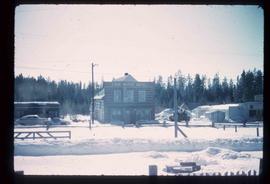
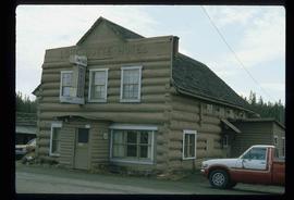
Print preview Close

Showing 17269 results

Archival description
Lordeau Hotel
2013.6.36.1.076.11 · Item · Sept. 1970
Part of David Davies Railway Collection

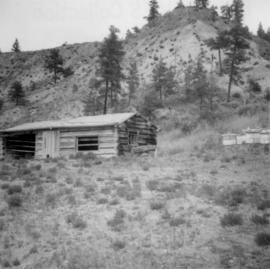
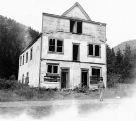
Photograph taken in the ghost town of Ferguson. About 8 deserted buildings remained, of which two appeared to be used as summer cabins. This building was the Lardeau Hotel.

2007.17.3.9 · Item · May 1921
Part of James Joseph Claxton Photograph Collection

Photograph depicts Lord French and several other men in military uniform inspecting a row of Royal Irish Constabulary officers. Typed annotation on recto of photograph reads: “Lord French’s farewell, May 1921: Before leaving Ireland Lord French inspects the Royal Irish Constabulary and the Auxiliaries in Phoenix Park. Immediately behind him is General H.H. Tudor, Chief of Police in Ireland, 1920-21.”

Loos
2012.13.1.86.10 · Item · 1975
Part of J. Kent Sedgwick fonds

Image depicts several buildings in the community of Loos, B.C.

Loos
2012.13.1.86.09 · Item · 1975
Part of J. Kent Sedgwick fonds

Image depicts several buildings in the community of Loos, B.C.

2020.05.07 · Item · October 1936
Part of Gordon Wyness Album

Photograph depicts Mount Begbie, noted by Wyness to be the highest point on the Cariboo Highway at mile 85. Mount Begbie is located at approximately 51°28'33''N, 121°22'00''W, on the east side of Cariboo Hwy, between 70 Mile House and 100 Mile House, in the Lillooet Land District. Also visible in this photograph is the Cariboo Highway road.

2020.05.06 · Item · October 1936
Part of Gordon Wyness Album

Photograph depicts Mount Begbie, noted by Wyness to be the highest point on the Cariboo Highway at mile 85. Mount Begbie is located at approximately 51°28'33''N, 121°22'00''W, on the east side of Cariboo Hwy, between 70 Mile House and 100 Mile House, in the Lillooet Land District. Also visible in this photograph is the Cariboo Highway road.

Longworth - Railway Tracks
2012.13.1.87.031 · Item · [between 1975 and 1995]
Part of J. Kent Sedgwick fonds

Image depicts two unidentified individuals standing next to the train station, and two railway tracks running through Longworth, B.C.

2011.3.3.64 · Item · 28 June 1928
Part of North Coast & Central BC Postcard Collection

Slightly elevated photograph of Prince Rupert buildings. A lone vessel is visible in the background. Printed annotation on recto reads: "Courtesy of Can Nat'l Rys. Prince Rupert. B.C." Handwritten annotation on verso reads: "Dear Elma. We reached Prince Rupert (in the picture) today. Friday we arrive at Skagway and the glaciers. Having a fine trip- good weather and a good crowd. Love from Claire." Postcard is addressed to: "Mrs. Claude Millersh, River Forest, Guerneville, Sonoma Co., California." Postcard is affixed with a two cent American stamp. Postmark on verso reads: "Ketohikan Alaska. Jun 28 3 PM 1928."

Lone Butte, BC
2020.05.22 · Item · Oct. 1936
Part of Gordon Wyness Album

Photograph depicts a view of Lone Butte, BC. The butte formation of the same name (Lone Butte) is visible in the background; a ranch or residence is visible in the foreground. Wyness notes that Lone Butte was the "last one [they] tied in". "Tying in" is a land surveying technique. Since the photograph is dated October 1936 and Wyness described the survey trip as lasting June 5 - October 8, 1936, that implies that Lone Butte was the last location they surveyed on this trip.

2012.13.1.87.013 · Item · [between 1975 and 1995]
Part of J. Kent Sedgwick fonds

Image depicts a pile of old logs on the bank of the Fraser River with mountains in the background. In the foreground, a set of railway tracks run through an uncertain location, likely Upper Fraser, B.C.

Logs and Machinery
2012.13.1.87.056 · Item · [between 1975 and 1995]
Part of J. Kent Sedgwick fonds

Image depicts numerous piles of logs, and two unidentified individuals operating an excavator with a "thumb" attachment during the demolition of the Upper Fraser town site. Map coordinates 54°06'51.6"N 121°56'26.3"W

Logging, Newport, BC
2020.08.21 · Item · [between 1911 and 1914]
Part of Pacific Great Eastern Railway Region Photograph Collection

Photograph depicts the unloading of logs from rail cars into the Mamquam River Blind Channel in Squamish (then Newport). The valley bottom around Squamish was logged from Mamquam River north to across the Cheakamus River before the construction of the Pacific Great Eastern Railway.

2014.2.1.09 · Item · [between 1938 and 1945]
Part of Cornel Neronovitch Logging and Sawmills Collection

Photograph depicts a loaded logging truck on corduroy log road near Peden Hill sawmill. The truck has three passengers--a man and two women--sitting on top of the loaded logs. The leftmost passenger is Mrs. Fred Tesluk; Fred Tesluk co-owned the Peden Hill mill with Cornel Neronovitch. Cornel Neronovitch stands at the right of the photograph, in front of the truck.