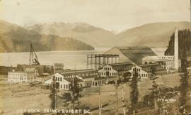
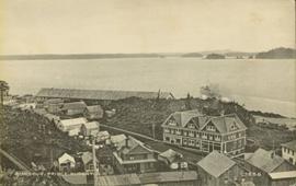
Elevated view of the buildings along the Prince Rupert shore, including the Prince Rupert Inn. The waterfront and some small islands can be seen in the background. Printed annotation on recto reads: "Harbour, Prince Rupert, B.C. 1658."
Boats, docks, ships and a large building in waterscape. Printed annotation on recto reads: “Prince Rupert B.C.” Handwritten annotation in pencil on verso reads: “McRae Bros”.
View of building, dock, harbour and small islands with snow peaked mountains in background. Printed caption on verso reads: “Port Essington B.C. Photo by P. E. Fisher”. Handwritten annotation in ink on verso reads: “up the Skeena”, in pencil on verso: “Port Essington, North Coast Commercial Coy”.
Image depicts the Hansard railroad bridge looking west. Map coordinates 54°04'37.9"N 121°50'46.3"W
Image depicts the Hansard railroad bridge taken from the new Hansard vehicle bridge. Map coordinates 54°04'58.1"N 121°50'58.0"W
Image depicts the new Hansard Bridge. Map coordinates 54°04'57.9"N 121°51'10.1"W
Photograph depicts some stumps and grassland in the foreground, a few buildings on the right, sparsely forested rocky hillside in the background.
Image depicts a hammer sitting in dirt at an uncertain location.
Image depicts a house on Blackwater Road.
Image depicts an old, half-collapsed building at an uncertain location.
Image depicts Haldi Lake near Prince George, B.C.
Photograph of the dirt road leading to Hagwilget Village. Residential buildings and a church are visible in the background. Printed annotation on recto reads: "W.W.W. Hagwilget Village."
Close view of bridge built with wooden planks, poles, and wires, braced from below, with triangles built into its frame. The bridge crosses Hagwilget Canyon on the Bulkley River, five kilometres from its confluence with the Skeena River. This is one of the many bridge structures that have crossed this location since at least 1859. Photograph was taken from one side of canyon, near bridge. Opposite canyon wall in background. Typed annotation glued to verso of photograph: "HAGWILGET - 'the gentle or quiet people'."
Photograph depicts two men and a horse on a bridge built with wooden planks, poles, and wires, braced from below, with triangles built into its frame. The bridge crosses Hagwilget Canyon on the Bulkley River, five kilometres from its confluence with the Skeena River. This is one of the many bridge structures that have crossed this location since at least 1859. Photograph was taken from a distance. Rocky riverbank in foreground, opposite shore in background behind bridge. Typed annotation in red ink on verso of photograph: "INDIAN BRIDGE, NEAR HAZELTON, B.C."
Photograph depicts bridge built with wooden planks and poles, braced from below, with triangles built into its frame. The bridge crosses Hagwilget Canyon on the Bulkley River, five kilometres from its confluence with the Skeena River. This is one of the many bridge structures that have crossed this location since at least 1859.
Handwritten annotation on recto of photograph: "old bridge at the Bulkley River."
Image depicts a church on a hill in Hagwilget, B.C.
Image depicts a bridge in Hagwilget, B.C.
Photograph depicts Henry Alexander, son of Marion and Archdeacon W.H. Collison, leaning on walking stick on top of rocky hill. Mountains in background.
Handwritten annotation on verso reads: "Henry Collison on prospecting trip. Portland Canal."
Photograph is a group photo of five men standing around a tent in a wintery wooded landscape; Knox McCusker stands first man from the right, with hands in pockets. Caption on verso reads: “Youthful K.F.McC. on the right. Probably Northern Ontario or Manitoba”.
Image depicts numerous individuals who appear to be searching among the rocks on a ledge at an uncertain location in the Peace River Region.
Image depicts a group of hikers examining something on the ground, most likely the small pink flower that is barely visible in the grass. The location is possibly near Riske Creek.
Image depicts a group of hikers on a hiking trail.
Image depicts a group of people hiking, possibly somewhere near Riske Creek, B.C.
Image depicts a group of people and two vans, apparently preparing to set out on a hike somewhere near Riske Creek, B.C.
Image depicts a group of hikers listening to a man, possibly a guide, speak. The location is possibly near Riske Creek, B.C.
Image depicts a group of hikers, possibly somewhere near Riske Creek, B.C.
Photograph depicts a game of horseshoes in foreground. Fence crosses midground in front of water, and hills can be seen on opposite shore in background. Handwritten annotation on recto of mounted slide reads: "Playing horse [shoes?] in Legac".
Group stands in foreground on what appears to be a wooden teeter totter. Fence crosses midground in front of water, and hills can be seen on opposite shore in background. Handwritten annotation on recto of mounted slide reads: "play ground in Legak [sic]".
Image depicts a group of people standing near a river. A glacier is visible in the background.
Image depicts a group of individuals and a bus with words that read: "Prince George Limousine & Charter." The river in the background is possibly the Peace River, and the location is possibly somewhere near Fort St. John, B.C.
Ground level view of the dry dock in Prince Rupert, BC. Printed annotation on recto reads: "Dry Dock Prince Rupert BC McRae Bros."
Ground level view of the Prince Rupert dry dock during what appears to be construction. Printed annotation on recto reads: "The Dry Dock of Prince Rupert."
Photograph depicts water flowing from ground in forest. Handwritten annotation on recto of photograph: "Atlin, The Grotto, Outlet of a subterranean stream (in limestone) on way to O'Donnell River."
Image depicts an aerial view of a grooved region of land at an uncertain location.
Image depicts an aerial view of grooves in the land near the Fraser River, possibly caused by glaciers.
Image depicts a view of grooves in the land near the Fraser River, possibly caused by glaciers.
Image depicts an aerial view of a grooved region of land at an uncertain location.
Photograph depicts the skins of two grizzlies, heads attached. A man stands beside the skins spread on elevated poles. There is alpine meadow and scrub trees in the background.
Image depicts a small graveyard at an uncertain location.
Photograph depicts close up view of gravel pit, ruler displayed for scale. Photograph speculated to have been taken at the plant or near the Cassiar airstrip. Stamped annotation on recto of photograph: "JUN. 1987".
Image depicts layers of gravel at the BCR site in Prince George, B.C.
Image depicts the grave of W.L. Meason in the upper Fraser Canyon.
Image depicts Grassy Plains, B.C.
Photograph depicts Granite Falls near the Wigwam Inn, Indian Arm, Vancouver, B.C.
Photograph depicts Granite Falls and wharf at Indian Arm, looking west from the top of the falls.