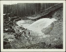
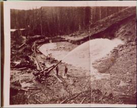
Photograph of a large explosion on a rocky shoreline. A bridge is visible in the foreground and a body of water is partially visible in the background. Annotation on recto reads: "McRae Bros Moving Mountains at Prince Rupert BC Apr 24th"
Photograph of a large explosion on a rocky shoreline. A bridge is visible in the foreground and a body of water is partially visible in the background. Printed annotation on recto reads: "McRae Bros Moving Mountains at Prince Rupert BC Apr 24th" Handwritten annotation on verso reads: "Rupert. July 17 1913. Dear [illegible]. Just a card for that album if you've got any room left by now. This is one of the blasts for the clearing of the drydock up here. [Illegible] W.M." Postcard is addressed to: "Miss C.M. Ranip[??] 931 Northlane Av.[sic] Seattle Wash." Two Canadian one cent stamps are affixed on verso. Postmark reads: "Prince Rupert BC. PM Jul 17 13."
Photograph depicts Moyie Lake, 15 miles south of Cranbrook, and Moyie Station. The tailings are from a lead and zinc mine directly to the right of the photograph on the hillside. The view is looking north.
Handwritten annotations on verso read: “Granisle Mine,” and “woman operators on strip mine”.
Photograph depicts a cannery on pilings with a body of water in the foreground with a forested area in the background.
Photograph depicts a cannery on wood pilings with several other buildings along a forested shoreline with a body of water and boat in the foreground.
Handwritten caption beside this photo reads: "Ned got a Moose". Photograph depicts a man named Ned holding the antlers on the head of a bull moose protruding from the fender of a car. Buildings and trees in background.
Photograph depicts the newsprint plant of MacMillan, Bloedell, and Powell River Ltd. In Powell River, B.C. The view is looking northwards and shows that the plant is working on Easter Day/
Photograph depicts the North peak of McDame mountain after extensive strip mining, South peak unmined in background. Old mine garage visible on right of West peak in foreground. Crusher plant partially visible on far right. Photograph believed to have been taken just prior to the development of the pit mine between the North and West peak.
Photograph depicts tramline in a strip cleared of trees on McDame Mountain, bucket in foreground. Handwritten annotation on recto of photograph: "#2 SECTION LOOKING NORTH". Photograph was glued to cardboard backing with the annotation: "1962".
Photograph depicts tramline in a strip cleared of trees on McDame Mountain, bucket in foreground. Handwritten annotation on recto of photograph: "1961 - 62".
Image depicts what appears to be a saw mill belonging to Northwood. The location is uncertain.
Image depicts the Northwood pulpmill in Prince George B.C.
Image depicts the Northwood Pulpmill in Prince George, B.C. taken from above the Nechako River looking east. Map coordinates 53°56'00.0"N 122°44'29.7"W
Image depicts the Northwood pulpmill in Prince George B.C.
Image depicts the office at the Northwood Upper Fraser Saw Mill and a sign which reads "Have a safe, quality day." Map coordinates 54.117916, -121.943351
Photograph depicts group of 12 men standing on steps at back of main office. Front row: Jack Berry, Mickey Dopson, Andre Beguin, Fred Murray. 2nd row: Dick Stevens, Rene Pasiaud. Third row: Craigie Hood, Alex Powell. Back row: Dr. Charles Cobb MD, Peter Davies, Chuck Caron (holding paper), Bill Johnston. Berry and Dopson are wearing hard hats. Windows and doors of office building in background. Stamped annotation on recto of photograph: "Munshaw Colour Service Ltd. OCT 24 1958".
Photograph depicts a once used booming boat made of log sections at a log dump on seashore about 5 miles north of Powell River, and opposite Harwood Island. Stern at left with prop guard.
Photograph depicts an old pelton wheel at a former quarry at Granite Falls on the northeast head of the Indian Arm.
Photograph depicts small square building with an elevated door, log pile on its left, and stand of trees in background. Handwritten photo caption below photograph reads: "Old Salmon cache. Fort St James, BC June 1923".
Photograph depicts two men standing beside beds of fish laid out to dry. More oolichan fish hang on tall structures in background.
Handwritten annotation on verso reads: "'Food for winter' Oolichans drying at Fishing Bay, Nass River".
Photograph depicts a group of men gathered around hole in ice. Two men in centre handle a net full of fish. Village can be seen on shore in background.
Handwritten annotation on verso reads: "Oolichan Fishing Nass River".
Photograph depicts groups of men gathered on ice. One man sits on ice sled in foreground. Village can be seen on shore in background.
Handwritten annotation on verso reads: "Chapt. II. No. 1. Fishing Bay. Olachan fishery on the ice."
Handwritten caption beside this photo reads: "1500wt 4x4". Photograph depicts small open cab truck with tire chains. Forest and unidentified buildings in background. A second vehicle is semi-visible on far left, as well as a pile of logs on far right.
Image depicts an open mining pit at an uncertain location; it is possibly Gibraltar.
Item is a photograph of officials attending the June opening of the Crestwood Forest Industries pulp mill in Cranbrook, until that time the only pulp mill built without benefit of a Pulp Harvesting Area (PHA) license to assure timber supply. Mr. Williston is on the left.
Photograph depicts large dump truck on its side in snowy forest clearing, exhaust still running. Lumber piles in foreground. Handwritten caption above this photo reads: "Over Easy".
Photographic overview of the Eagle Lake Sawmill. Handwritten annotation in pen on verso reads: “The mill.”
Overhead photograph of Giscome with the Eagle Lake Sawmill's beehive burner clearly visible in left foreground. Handwritten annotation in pen on verso reads: “Part of our community. school * ”
Photograph depicts an oxen powered log carrier with wheels that are approximately 10 feet in diameter. It is at Pioneer Park and Museum near Totem Lake, 3 miles north of Yahk and 30 miles east of Creston.
Photograph of a large waterfront factory. Annotation on recto reads: "Pacific Mills, Ocean Falls, BC. No. 2935."
Photograph depicts the lumber yard at Peden Hill sawmill, likely after the fire that burnt down the first mill at that location.
Image depicts an aerial view of areas that have been used for logging around Prince George, B.C.
Image depicts an aerial view of the Ahbau area somewhere near Prince George, B.C.
Photograph depicts a two men standing on piles of whale bones at a whaling station. Annotation on verso of photograph states: "Pile of whale bones, Whaling station, Vancouver Is."
Photograph depicts the Pinchi Lake mercury mine as seen from the water. Some buildings appear to be under construction. Handwritten annotation on verso reads: "Pinchi Lake min (mercury).
Photograph depicts a portion of the pit in foreground at the Cassiar mine. Crushing plant visible in centre below base of West peak. Footwall road in midground, mine valley in background. Building near trucks at top of pit was called the "shifter shack," where crews were relieved or dropped off for work.
Photograph depicts the pit head refuse at Extension Coal Mine, 5 miles southwest of Nanaimo. It worked between 1901 and 1931.
Photograph depicts a portion of the Cassiar pit in right foreground. Crushing plant visible to left of pit, West peak visible in right background. Mountain range can be seen in distance.
Photograph depicts an unidentified man mining in rocky area, trees and hills in background. Handwritten annotations on verso of photograph: "PLACER MINER WSHING FOR GOLD FINDLAY RIVER BC", "PHOTO WWW".
Two men stand below a large upright hose that is spraying a powerful stream of water against the side of a rocky hillside. Annotation on verso of photograph states: "Placer Mining Hixon (Hungry Thirties) This picture taken on top off Hill Across from Ques. Qarts. Maybe 800 Ft. west of Quarty There pictures taken approx 45 years ago Your friend(?) Box 156 Squamish B.C. Dec. 19/78"
Photo is adhered to paper backing, upon which handwritten annotation on recto reads: “Placer mining Hixon B.C. Hungry 30ies. This picture taken on top of hill across from Quesnel Quartz Mine maybe 800 ft west of Quartz taken approx 45 yrs ago (1933) 1978.12.19”
Five unidentified miners pose for a photo. Logs and wood scraps in foreground, forest in background.
Printed annotation on recto of photograph: "PLACER MINING, ATLINTOD RIVER, ATLIN, B.C. A.C. HIRSHFELD NO. 753."
Image depicts a pulp mill in Port Edward, B.C.
Photograph depicts boy on bike, and group of men in front of hull on trailer pulled by truck. Railway tracks visible on right, forest and hills in background.
Photograph depicts a crane behind rail tracks on left, main hook block suspended above boat hull resting on railway flatbed. Group of men in foreground, one man on hull. Trees and hills in background.
Photograph depicts boat hull resting on trailer flatbed pulled by truck. Trees and hills in background.
Photograph depicts middle section of boat hull on flatbed, trees in background.
Photograph depicts large square model of the new mill building that was built at the Cassiar plant site in 1970. Model is displayed on platform draped with green material. Machinery modeled inside the structure is colour-coded.