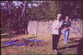
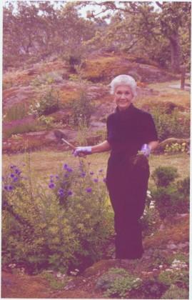
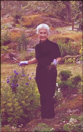
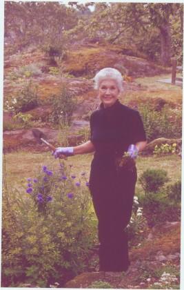
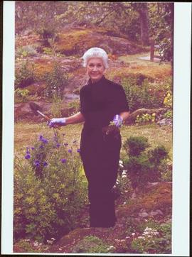
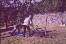
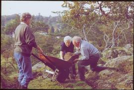
Photograph was taken at Government House in Victoria, B.C.
Handwritten annotation on verso reads: “Govt House, Working on Terrace Garden, Nov 2004".
Photograph was taken at Government House in Victoria, B.C.
Handwritten annotation on verso reads: “Govt House, Working on Terrace Garden, Nov 2004".
Stone wall runs in background. Photograph taken at Terrace Gardens, Government House, Victoria, BC. See item 2009.6.1.658 for similar image.
Handwritten notation accompanying print reads: “Terraces Gardens (I created 6 one for each of you) small”.
Photograph depicts Iona Campagnolo walking by the Bulkley River with people sledding in the background.
Photograph depicts Iona Campagnolo sitting by the Bulkley River near Moricetown.
Photograph depicts Iona Campagnolo with a fur hat standing by a bridge over the Bulkley River by Moricetown.
Photograph depicts Iona Campagnolo and Peter Jones surveying the damage to Highway 16 from a flood.
Photograph depicts Iona Campagnolo and Peter Jones standing by a lake on highway 37.
Photograph depicts Iona Campagnolo looking over her shoulder with Peter Jones by a lake on highway 37.
Stone wall runs in background. Photograph was taken at Terrace Gardens, Government House, Victoria, B.C. See item 2009.6.1.660 for similar image.
Image depicts what is possibly an intrusive volcanic landform somewhere near Miworth, B.C.
Image depicts the Inlander Hotel in Hazelton, B.C. The peak of the Rocher de Boule mountain is visible in the background.
Several large buildings on a rocky shore. Wood piles and a crane are visible in the background. Annotation on recto reads: "Prince Rupert BC"
Image depicts Indianpoint Lake.
Photograph depicts a view of Indian Arm, looking south from Granite Falls.
Image depicts a boulder protruding from layers of sediment with a hammer beside it for size reference. It is located somewhere in Soda Creek, B.C.
Photograph depicts man standing on ice over river, near unidentified bridge. Trees on opposite shore in background. Handwritten annotation on recto: "This was the way the ice Jammed up in the river at Princeton. This bridge is normally 13 ft above the water."
Image depicts an unidentified individual drilling into the ice.
Image depicts a hand-held ice drill.
Photograph depicts pieces of ice floating on river, forest trees on either side.
Photograph depicts pieces of ice floating on river, forest trees on either side, hills in distance.
Photograph depicts power plant by waterfall. Extensive construction materials and structures can be seen scattered to left of plant. River in foreground, forest and hills in background. Typed annotation on verso of photograph: "Northern B.C. Power Co. Falls River Plant Prince Rupert B.C."
Image depicts the old log buildings of the town of Hydraulic, B.C.
Photograph is one of 13 images printed from digital format on a CD-R featuring members of a group referred to as 'Terracites' (see item 2009.6.1.697) pictured in the gardens; see also items 2009.6.1.698 - 2009.6.1.710.
Image depicts a small grey building, possibly Raven Cabin, sitting at the foot of a ridge.
Image depicts the Raven Lake Hut on the other side of Raven Lake.
Photograph depicts an unidentified hunting guide laying on a grassy slope searching for game through a pair of binoculars while two pack horses stand by. In the background an alpine lake is visible surrounded by forested foothills and a mountain range.
Image depicts a cabin and several other buildings, possibly located in Hudson's Hope, B.C.
Image depicts a view of Howe Sound from the Stawamus Chief Nature Trail to the Stawamus Chief Mountain, which is often incorrectly referred to as "Squamish" Chief.
Image depicts the Britannia Mine, which closed in 1974 and is now a museum. "Anaconda" was the last operating owner.
Image depicts Howe Sound.
Image depicts a number of houses built on stilts over a body of water in an uncertain location.
Image depicts a row of houses in Upper Fraser, B.C. Map coordinates 54°06'51.6"N 121°56'26.3"W
Image depicts several houses, and three goats standing on a narrow dirt road. The location is uncertain, likely Sinclair Mills, B.C.
Image depicts a view of numerous houses and a ballpark at an uncertain location. It is possibly located somewhere in the Peace River Region.
Image depicts numerous houses, and an unknown child standing in a street at Island Cache.
Image depicts a few houses in Island Cache.
Image depicts a number of houses at an uncertain location, possibly Williams Lake, B.C.
Image depicts a number of small houses at Island Cache.
Image depicts a few houses in Island Cache. There are two unknown individuals present.
Image depicts a few houses and a dog on a porch at Island Cache.
Image depicts a number of small houses at Island Cache.
Image depicts a house with ivy growing over it. The location is uncertain.