Print preview Close
Showing 671 results
Archival description
Forest Cover Map 93J-10-d
Forest Cover Map 93J-10-d
"First addition to townsite of Central Fort George"
"First addition to townsite of Central Fort George"
Fantail Lake, Cassiar District, British Columbia
Fantail Lake, Cassiar District, British Columbia
Existing Development - Mont Ste. Marie, Lac Ste-Marie, Quebec
Existing Development - Mont Ste. Marie, Lac Ste-Marie, Quebec

Exhibit B: Amendment to Special Use Permit #19070: Bowron Floodplain Addition, Aleza Lake Research Forest

Exhibit B Amendment to Special Use Permit #19070 Bowron Floodplain Addition Aleza Lake Research Forest

Exhibit A Sheet 4: Amendment to Special Use Permit #19070: Bowron Floodplain Addition, Aleza Lake Research Forest

Exhibit A Sheet '4' Amendment to Special Use Permit #19070 Bowron Floodplain Addition Aleza Lake Research Forest

Exhibit A Sheet '3' Amendment to Special Use Permit #19070 Bowron Floodplain Addition Aleza Lake Research Forest

Exhibit A Sheet '2' Amendment to Special Use Permit #19070 Bowron Floodplain Addition Aleza Lake Research Forest

Exhibit A Sheet '1' Amendment to Special Use Permit #19070 Bowron Floodplain Addition Aleza Lake Research Forest
E.P. 646.3
E.P. 646.3
"Energy Resources of British Columbia"
"Energy Resources of British Columbia"
"East Central British Columbia" 1993 map
"East Central British Columbia" 1993 map
"Eagle Lake Spruce Mills Ltd. Giscome, British Columbia"
"Eagle Lake Spruce Mills Ltd. Giscome, British Columbia"
"Eagle Lake Sawmills Ltd. Giscome BC Plan of Sawmill and Adjacent Buildings"
"Eagle Lake Sawmills Ltd. Giscome BC Plan of Sawmill and Adjacent Buildings"
Duke of Sutherland
Duke of Sutherland
Dr. Philip Burton Forestry Collection
Dr. Philip Burton Forestry Collection
Dr. Paul Sanborn fonds
Dr. Paul Sanborn fonds
District of Kitimat Land Ownership
District of Kitimat Land Ownership
"Distribution of Uranium Exploration Mineral Claims and Radioactive Occurrences"
"Distribution of Uranium Exploration Mineral Claims and Radioactive Occurrences"
Distribution of Solid Mineral and Petroleum Resources in British Columbia
Distribution of Solid Mineral and Petroleum Resources in British Columbia

Dewey Logging Co. Ltd. X72108 annotated

Dewey Logging Co. Ltd. X72108

Dewey Logging Co. Ltd. Logging Plan of T.S.X. 72108
Development Study - Northern Resources
Development Study - Northern Resources
Development Plan Forest Licence A27771
Development Plan Forest Licence A27771
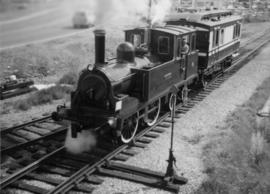
David Davies Railway Collection
Crooked Creek Provincial Forest
Crooked Creek Provincial Forest
"Cranbrook Hill Greenway Multi-use Trail"
"Cranbrook Hill Greenway Multi-use Trail"

C.P. 825, 826, 410, 420 - F.L. A18165 - Aleza Lake Forest - P.G.T.S.A.
"Cowichan Lake, British Columbia"
"Cowichan Lake, British Columbia"
"Cowichan Lake, British Columbia"
"Cowichan Lake, British Columbia"
"Cottonwood River"
"Cottonwood River"
Cottonwood Island maps and plans
Cottonwood Island maps and plans
Cottonwood Island general file from the City of Prince George
Cottonwood Island general file from the City of Prince George
Cottonwood Island and Island Cache
Cottonwood Island and Island Cache
Corner Brook, Newfoundland Tourist Map
Corner Brook, Newfoundland Tourist Map
"Coquitlam, Port Coquitlam, Port Moody"
"Coquitlam, Port Coquitlam, Port Moody"
Company Operating History series
Company Operating History series
"Comox & Nanaimo Coalfields Properties and Geology"
"Comox & Nanaimo Coalfields Properties and Geology"
Community Involvement
Community Involvement
Columbia River Treaty
Columbia River Treaty
Columbia Cellulose Company, Ltd. fonds
Columbia Cellulose Company, Ltd. fonds
Colonial exploration maps
Colonial exploration maps

College Heights-Southwest Existing Land Use
Collected Works
Collected Works
"Cluculz Lake, British Columbia" 1977 map
"Cluculz Lake, British Columbia" 1977 map
Clones etc. 1999
Clones etc. 1999
Clinton Creek Aerial - Flight Index
Clinton Creek Aerial - Flight Index