Showing 3756 results
Archival description
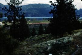
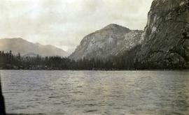
Oscar Peak

Oscar Peak
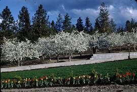
Tulips and cherry blossom trees
Mount Boucherie orchards
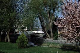
Kelowna park entrance
Topographical Sketch Map of Omineca and Finlay River Basins, British Columbia
Topographical Sketch Map of Omineca and Finlay River Basins, British Columbia

Hart Highway Existing Land Use
Highway 16 West: Gateway to Alaska
Highway 16 West: Gateway to Alaska
Preemptor's map Sheet No. 3 Valleys of Fraser, Salmon & Willow Rivers in Fort George and Peace River Land Recording Districts
Preemptor's map Sheet No. 3 Valleys of Fraser, Salmon & Willow Rivers in Fort George and Peace River Land Recording Districts
B.C. Ghost Town Map
B.C. Ghost Town Map
Centennial Map of Canadian History and Achievements, 1867 to 1967
Centennial Map of Canadian History and Achievements, 1867 to 1967
Colonial exploration maps
Colonial exploration maps
British Columbia Mountains
British Columbia Mountains
Stuart Lake, Fort St. James, and Fraser Lake area map
Stuart Lake, Fort St. James, and Fraser Lake area map
A look at Canada
A look at Canada
Pre-emptor's map of Fort George
Pre-emptor's map of Fort George
British Columbia Biotic Regions
British Columbia Biotic Regions
Kitimat City Centre
Kitimat City Centre
Cariboo Estate Map
Cariboo Estate Map
British Columbia Climatic Regions
British Columbia Climatic Regions
Central British Columbia Map
Central British Columbia Map
Kitimat-Stikine Regional District Regional Resource Inventory
Kitimat-Stikine Regional District Regional Resource Inventory
Upper Fraser research project
Upper Fraser research project
Group of boys playing horseshoes in Lejac, BC
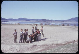
Group of boys at playground in Lejac, BC
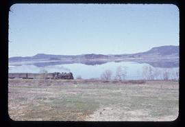
Train passing Fraser Lake near Lejac, BC
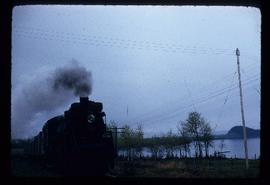
Train approaching Lejac, BC
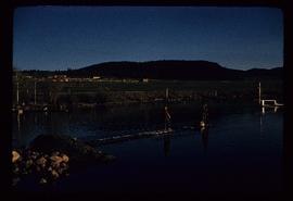
Two unidentified boys playing on lake in Lejac, BC
Trans-Canadian Alaska Railway Survey: Plan showing progress of survey parties
Trans-Canadian Alaska Railway Survey: Plan showing progress of survey parties
Trans-Canadian Alaska Railway Proposed Route
Trans-Canadian Alaska Railway Proposed Route
Plan showing provincial government property in the subdivision of Lots 933 & 934, Group 1, Cariboo District, South Fort George, British Columbia, to be offer for sale at public auction
Plan showing provincial government property in the subdivision of Lots 933 & 934, Group 1, Cariboo District, South Fort George, British Columbia, to be offer for sale at public auction
Union Steamship Company of British Columbia Map No. 2 Northern Run
Union Steamship Company of British Columbia Map No. 2 Northern Run
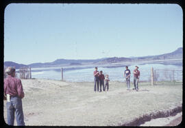
View of St'a7mes village from Squamish wharf
"Canada Federal Electoral Districts - 1987"
"Canada Federal Electoral Districts - 1987"
"City of Prince George Boundary Expansions Since Incorporation in 1915"
"City of Prince George Boundary Expansions Since Incorporation in 1915"
"City of Prince George"
"City of Prince George"
City of Prince George
City of Prince George
"City of Prince George"
"City of Prince George"
"City of Prince George Boundary Expansions Since Incorporation in 1915"
"City of Prince George Boundary Expansions Since Incorporation in 1915"

Visual notes from the 2020 Public Health Summer Institute
![City of Prince George - Schedule C of the Official Community Plan - Long Range Land Use Map [May 2008 Amendment]](/uploads/r/northern-bc-archives-special-collections-1/4/3/a/43a9e75941f1542735d999de340307d163e79dffdadbf4546bb9346b63f7e734/2023.5.1.41_-_2008_May_-_City_of_Prince_George_Long_Range_Land_Use_Map_JPG85_tb_142.jpg)
City of Prince George - Schedule C of the Official Community Plan - Long Range Land Use Map [May 2008 Amendment]

City of Vancouver, British Columbia
![City of Prince George - Schedule C of the Official Community Plan - Long Range Land Use Map [October 2006 Amendment]](/uploads/r/northern-bc-archives-special-collections-1/6/d/6/6d643c10801eba2ac493689972e57429dba42ec7592f54cb55151b96362d7048/2023.5.1.40_-_2006_Oct_-_City_of_Prince_George_Long_Range_Land_Use_Map_JGP85_tb_142.jpg)
City of Prince George - Schedule C of the Official Community Plan - Long Range Land Use Map [October 2006 Amendment]

City of Prince George - Schedule C of the Official Community Plan - Long Range Land Use Map
![City of Prince George - Schedule C of the Official Community Plan - Long Range Land Use Map [May 2006 Amendment]](/uploads/r/northern-bc-archives-special-collections-1/6/5/5/65536bc04aa97580c140131651dc357dfe5c3a1315822394f388d96940bc39cb/2023.5.1.39_-_2006_May_-_City_of_Prince_George_Long_Range_Land_Use_Map_JPG85_tb_142.jpg)
City of Prince George - Schedule C of the Official Community Plan - Long Range Land Use Map [May 2006 Amendment]

VLA Lands
![City of Prince George - Schedule B of the Official Community Plan, Bylaw No. 5909 [2001 Amendment]](/uploads/r/northern-bc-archives-special-collections-1/c/3/6/c36392b90696286cc6281e8cc2efbf7691c2617726495fa28db2cbdcc20e4e4c/2023.5.1.36_-_Official_Community_Plan_City_of_PG_Schedule_B_2001_JPG85_tb_142.jpg)
City of Prince George - Schedule B of the Official Community Plan, Bylaw No. 5909 [2001 Amendment]

City of Prince George - Soil Removal and Deposit Bylaw No. 7022 - Schedule A

City of Prince George - Plan for Soil Removal and Deposit
![City of Prince George - Schedule B of the Official Community Plan, Bylaw No. 5909 [1998 Amendment]](/uploads/r/northern-bc-archives-special-collections-1/d/6/d/d6d1c4e7e37fc948b97b3caa36447b52f7d2b76b13d45e3710aefee7b13840f0/2023.5.1.33_-_1998_Official_Community_Plan_City_of_PG_JPG85_tb_142.jpg)
City of Prince George - Schedule B of the Official Community Plan, Bylaw No. 5909 [1998 Amendment]