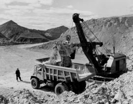
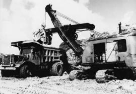
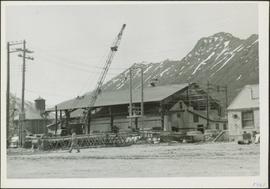
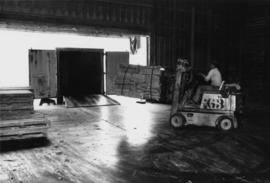
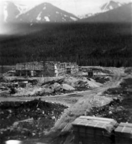
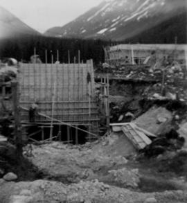
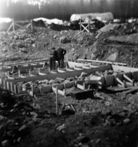
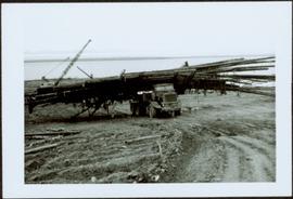
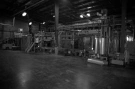
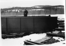
Photo depicts workers at construction site of Cassiar's new mill building.
Photograph depicts the Cassiar mine. North peak featured in left background, South peak in right background, and West peak in right foreground. Area to left of the mining pit and West peak was called the "cirque waste dump." Mountain range visible in distance.
Photograph depicts the pit mine, and road in valley below. Town of Cassiar can be seen in distance at foot of south mountain range.
Photograph depicts the Cassiar mine, switchback road in foreground, mountain range in background. Pit is visible behind the West peak. The new mine garage can be seen on West peak just above "#7 switchback" in centre of image. Photograph was taken from the air, portion of plane visible in top left of image.
Photograph depicts the Cassiar mine in mountain range. Crushing plant and tramline station visible in foreground, and new mine garage can be seen on West peak on far left.
Photograph depicts shovel loading Kenworth haul truck in mine. Unknown man stands on left, mountain range in background.
Photograph depicts cable-operated shovel loading two Kenworth haul trucks on road in mine area at high elevation. Three unidentified men are gathered around truck in foreground. Valley and mountain range in distance.
Photograph depicts unknown man driving bulldozer in foreground. Shop area in background, numerous haul trucks and dozers throughout. Old mine garage can be seen in center behind dozer, and the mine's West Peak rises on right behind shop buildings. Mountain range in background. Handwritten annotations on recto of photograph: "Cassiar Asbestos Corporation Limited. Cassiar B.C. Mining asbestos ore elevation approx 6000 ft. above sea level. McDame mountain, Northern British Columbia"; "Toronto Set"; "D - 336"; "-4 1/2 -". What appears to be framing measurements are annotated on verso.
Photograph depicts Wabco in left foreground in front of shop building, tractor, and miscellaneous supplies. Mine valley and mountains in background. Handwritten annotation on recto of photograph: "Cassiar B.C. 1970 June 23 by Tom Kiefer".
Photograph depicts red truck dumping waste at what is believed to be the tailings pile at the Cassiar plant. Small building and unidentified individual in bottom left foreground, valley and mountains in background. Photo caption next to printed copy of image in 1953 Annual Report: "Stockpile of 80,000 tons of Ore at Mill."
Photograph depicts the large bearing cups of one of the Ruston Hornsby diesel engines that turned the generators in the power house on the Cassiar plant. Engine believed to be under repair. Electric panels and unidentified individual in background.
Photograph depicts crawler cable shovel, bucket over box of Kenworth truck in excavation area of mine. Handwritten annotation on verso of photograph: "1961".
Photograph depicts a large shelter over building believed to be power house. Electricity lines cross midground and run to power house. A man can be seen crossing the foreground by steel frame supplies, and a second building is partially visible on right. Mountains stand in background and a crane can be seen operating in front of power house. Handwritten annotation on verso of photograph: "1961".
Photograph depicts unidentified man lifting package of asbestos bags with forklift in large building. Truck in background, ready for loading.
Photograph depicts tramline buckets and tower on plantsite. Vehicles, building materials, and unidentified buildings also visible on plantsite (including what appears to be a water tower). Mountains and valley in background. Handwritten annotation on verso of photograph: "Cassiar June 15 71".
Photograph depicts two unidentified men in front of yellow and red helicopter at unknown location. Power lines and trees in background. It is possible that this photo may have been taken at Clinton Creek, Y.T. rather than Cassiar, B.C.
Photograph depicts row of houses behind trees. Road, front yards, and vehicle in foreground, mountains in background.
Photograph depicts long building with blue siding. Security was located at corner of building in centre foreground, behind stop sign. Single red door on left was main entrance into mine dry, where individuals were checked through security. Two larger windows on left indicate the location of the mine store where work apparel could be purchased. Building also housed change house (see item 2000.1.1.3.19.121) and offices of the mine department supervisory staff. Employee parking lot located out of frame to right. Mill building stands in background, tramline dump station on left. Ore car visible, about to enter dump station. Unidentified man and child can be seen in foreground.
Photograph depicts mill building under construction, mountains in background. Corresponding note on accompanying photo description page: "Pictures taken July 3rd, 1952. 5. Mill. Truck Dump and concrete mixers in foreground. Taken from top of water tower and looking south."
Photograph depicts men working on truck dump construction, mountains in background.
Photograph depicts men building truck dump in foreground, building believed to be power house in background. Corresponding note on accompanying photo description page: "Pictures taken June 11th: (3) Framing water tank tower. Water well in foreground and tower timbers and oil tanks in background. Looking east." [Note believed to be incorrect.]
Photograph depicts water tower framework. Building materials, truck, and oil tanks in foreground; mountains in background. Corresponding note on accompanying photo description page: "Pictures taken June 28th, 1952: (8) Water tower erection. Looking northwest."
Photograph depicts men on plant site. Corresponding note on accompanying photo description page: "Pictures taken June 28th, 1952: (9) Truck dump with concrete poured in foreground. Power house in background. Looking north from mill."
Photograph depicts 7 men working on building speculated to be foundation for diesel engine. Oil tanks and mountains in background.
Photograph depicts 8 men and possibly 1 woman working in construction area, mountains in background. Corresponding note on accompanying photo description page: "2. Pouring concrete for second Ruston diesel engine. In foreground is the first diesel foundation stripped of concrete form ready for engine. Looking west."
Photograph depicts mountain side, semi-covered in snow. Snowbank in foreground. Corresponding note on accompanying photo description page: "8. Shows snow conditions in gully just north of talus deposit on south slope. Note considerable snow still above road. Estimated depth of snow here to be from 10 to 20 feet [see also item 2000.1.1.2.229]."
Photograph depicts man standing on dirt road. Snowbank to right of man is almost shoulder-height and disappears as road continues. Corresponding note on accompanying photo description page: "12. Indicates snow along the mountain road."
Photograph depicts four bunkhouse buildings leading to recreation hall at Watson Lake Airport. Power poles on left. Corresponding note on accompanying photo description page: "7. Same group of buildings as in picture No. 4 [see item 2000.1.1.2.236] showing steel building on the end [see item 2000.1.1.2.235]. Picture taken looking east. Note: There are at least as many more buildings again as shown in these snaps."
Photograph depicts foundation framework, trees and mountains in background. Corresponding note on accompanying photo description page: "7. Framing diesel engine foundations. Tarp overhead to keep out snow and rain. Oil tanks in background."
Photograph depicts 2 men working in building project area, trees in background. Corresponding note on accompanying photo description page: "1. Building concrete forms for diesel engine footings. Oil tanks in background."
Photograph depicts DeCecco wearing helmet and snowsuit while seated on Arctic Cat "Pantera".
Photograph depicts ore cars on cables running between tramline towers on left. Road in right foreground, building and McDame mountain in background. Tramline ran through mine valley, between loading station in mine and dump station at mill on plantsite.
Photograph depicts palletizer machinery, where bags of asbestos fibre were shrink-wrapped and made ready for shipping pallets. Palletizer was located near shipping (believed to be in mill building).
Photograph depicts Chris Tates seated at table with paperwork in left foreground. David Pewsey stands behind on right, pointing to what appears to the Fibre Loading Schedule. Pewsey was supervisor of the Fibre Storage Shed. Both men wear hardhats. Tates believed to be wearing gold nugget Cassiar ring on left hand.
Item is a photograph of Percy Gray and pilot Ian Watt gassing up their plane at Finlay Forks before continuing their survey of the Rocky Mountain Trench in March 1957.
Item is a photograph of the B.C. Electric Board taken the day after the company’s take over by the Social Credit government on August 1, 1961. Pictured from the left are: Bill Means, former Lieutenant-Governor Frank Ross, Einar Gunderson, board secretary W. Goth, Gordon Shrum, Mr. Williston, Hydro lawyer Arthur Fouks and John Dunsmuir.
Item is a photograph of the Bennett Dam.
Item is a photograph of Princess Margaret arriving by Canadian Air Forces jet at Prince George. Lieutenant-Governor Frank Ross is walking beside the Princess.
Originally mounted on a poster with photographs 115, 115.2, 115.3.
Item is a photograph of a truck hauling logs from the shores of a lake.
Item is a photograph of the construction of the W.A.C. Bennett Dam
Item is a photograph of people and boats on a river’s edge.
Item is a photograph of a man pulling a furniture laden cart along a road.
Item is a photograph of people and boats on the shore of a river.
Item is a print of a photograph of a person poling a dugout canoe between 1906 and 1908.
Item is a photograph of Mr. Williston speaking at a rally in Mount Robson Park to encourage government support for the Jasper - Prince George highway on June 2, 1957.
Item is a photograph of Princess Margaret with Lieutenant-Governor Frank Ross and Mr. Williston taken on July 17, 1958 after disembarking in Prince George from a Canadian Forces plane.
Photograph depicts a Canadian National Railway train derailment. Location is unknown.
Photograph depicts a Canadian National Railway rail yard at Prince Rupert, BC.
Photograph depicts the Dorreen railway station on the Canadian National Railway main line, located on the west bank of the Skeena River between Cedarvale and Terrace, British Columbia. CN boxcars visible on the siding.
Typed annotation on verso reads: "Matt Caldwell on GTP/CNR turntable at Endako c. 1950. Pre-WW1, Matt worked as boiler maker for Grand Trunk in Montreal & later in Edson. He served in WW ! with First Pioneers from P.G. and after the war became (eventually) Loco Foreman in Endako: retired c. 1950. Photo: May Caldwell Dockrill (daughter) & "Deeper Roots & Greener Valleys", published by Fraser Lake & District Historical Society."