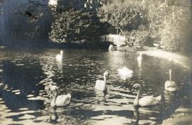
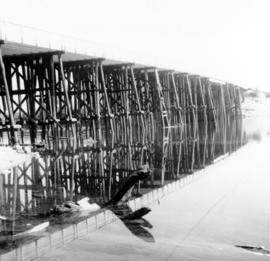
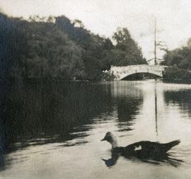
Photograph depicts the bridge at Goodacre Pond in Beacon Hill in Victoria, BC. Duck in foreground.
Photograph depicts the bridge at Goodacre Pond in Beacon Hill in Victoria, BC. Swans are swimming in the pond and there is a path and footbridge behind the pond.
Bridge is 200ft. above water.
Photograph taken on Highway 16, between Vanderhoof and Burns Lake. This road and bridge was to be passed by a new section of the highway. To the date the photograph was taken, all traffic between Prince George and Prince Rupert had used the bridge.
Photograph depicts eight men building a wooden bridge over a section of lake. A mining (?) work camp is visible in a foreseted background.
The photograph depicts a partially built wooden bridge over the Anzac River. Annotation on reverse side of the photograph states, "The Pas Lumber Company Ltd Oct 19/75 Anzac River - Colbourne Road, Quadra Coast."
The photograph depicts a partially built wooden bridge over the Anzac River. A man is walking near the bridge. A turned over crane can be seen in the middle of the river. Annotation on reverse side of the photograph states, "The Pas Lumber Company Ltd Oct 19/75 Anzac River - Colbourne Road, Quadra Coast."
The photograph depicts a partially built wooden bridge over the Anzac River. Annotation on reverse side of the photograph states, "The Pas Lumber Company Ltd Oct 19/75 Bridge - Anzac River - Colbourne Road, Quadra Coast."
The photograph depicts a crane on a partially built wooden bridge over the Parsnip River, B.C. Annotation on reverse side of the photograph states, "The Pas Lumber Co Parsnip River Bridge #2, Missinka, River late 1970's Quadra construction crane"
Photograph depicts bridge built with wooden planks and poles, with triangles built into its frame. Water rapids in foreground, opposite shore in background behind bridge. This is speculated to be one of the bridges that crossed the Hagwilget Canyon on the Bulkey River since 1859, five kilometres from its confluence with the Skeena River. See items 2009.5.1.69 - 2009.5.1.71.
Photograph depicts bridge crossing over the Campbell River, 1 mile west of downtown Campbell River.
Photograph depicts bridge #269 crossing the West Kettle River. This is located approximately 2 miles north of the Rhone crossing and at about mile 27 on the CPR line in the Carmi Subdivision. The view is looking north and upgrade.
Photograph depicts bridge #504 crossing Wilkinson Creek at the top end of the Sawyer loop. This is at about mile 50.75 on the CPR line in the Carmi Subdivision. The elevation here is 2973 ft. and the line is climbing at an even ascent. The view is looking northeast.
Two hikers walking across a wooden plank bridge spanning river
Photograph depicts a bridge in Chase, BC
Photograph depicts the East Fork Canyon Bridge over Klo Creek, located at mile 86.5 on the CPR Kettle Valley Railway in Myra Canyon. The bridge is 365 ft. long, 148 ft. high, and has 5 through plate girder spans. The view is looking southwest.
Photograph depicts the East Fork Canyon Bridge over Klo Creek, located at mile 86.5 on the CPR Kettle Valley Railway in Myra Canyon. The bridge is 365 ft. long, 148 ft. high, and has 5 through plate girder spans. The view is looking northeast.
Photograph depicts the East Fork Canyon Bridge over Klo Creek, located at mile 86.5 on the CPR Kettle Valley Railway in Myra Canyon. The bridge is 365 ft. long, 148 ft. high, and has 5 through plate girder spans. The view is looking north.
Photograph depicts a log bridge interrupting a wide dirt road in forest. Distant hills in background. Image has been cropped to an oval shape. Handwritten annotation on verso of photograph: "Fort George - Hazleton Highway Near Burn's Lake".
Caption: Bridge of Sighs, Black Creek. The water being rather fst, deep and black for wading, we feld the tree across. Bob and self (Jim Mackenzie?) identified. Item is a photograph of two men laden with packsacks, traversing a fallen log across a creek.
Photograph depicts a bridge on an abandoned railroad grade. Handwritten annotation on verso reads: " bridge on abandoned coal branch grade Cademin Alberta, Mountain Park Alberta"
Postcard depicts a bridge on the CPR line.
Photograph depicts a bridge on the Upper Clearwater Rd., 10 miles north of Clearwater. The town is 70 miles north of Kamloops. The road leads north (to left side of photo) to the entrance of Wells Gray Provincial Park.
Photograph depicts bridge over the Alouette River, 3.5 miles north of Port Hammond and close to Dewdney Truck Road in the Fraser Valley.
Photograph depicts a bridge over the Alouette River, 3.5 miles north of Port Hammond in the Fraser Valley.
Photograph depicts a bridge over Brookmere public road in Kingsvale. Davies noted that there must have been a problem around the bend as the "Whistle" sign and the imposed speed restriction of 30 mph suggested.
Photograph depicts a bridge over Clearwater River.
Photograph depicts a short wooden bridge spanning Dog Creek mid-ground and a stand of trees in the background. There are many Dog Creeks within British Columbia, it is believed this Dog Creek is located just south of Fort St. James, BC. Handwritten photo caption below photograph reads: "Dog Creek".
Photograph depicts a bridge over Kettle River.
The photograph depicts a logging truck driving on a steel-trussed bridge over the Klinaklini River, B.C. Annotation on back of photograph states, "Global Pace-Setter -- World's longest laminated-timber, steel-trussed span is 575-ft. Klinaklini, near Knight Inlet, 150 miles north of Vancouver. Built for B.C. Forest Products Ltd., which a quarter of a century ago pioneered province's first laminated logging bridge, structure has a clear span of 207 feet, plus approaches. It opens to logging operations a previously inaccessible 17,000-acre stand of spruce, fir, hemlock and cedar. Laminated components for span were provided by Koppers International Canada Ltd., subsidiary of Koppers Company, Inc., Pittsburgh, Pa., pioneers in glued wood technology."
Photograph depicts a bridge over Lardeau River. Survey stakes at the point where the photograph was taken suggested that a new bridge would be built within the next 2 or 3 years.
Photograph depicts a bridge over the Nanaimo River on the road between Nanaimo and Cedar-by-the-Sea, looking west, downstream to river.
Photograph depicts the bridge over the Nicola River at Spences Bridge in the north Fraser Canyon, looking downstream.
Photograph depicts the bridge over the Nicomen Slough (which was a turgid smal arm of the Fraser River at this point) at Dewdney. It was fairly recently built.
Photograph depicts a bridge over Otter River, about 3/4 miles southeast of Tulameen.
Peace River valley, Alberta
Photograph depicts a bridge near the beginning of the Seton Portage to D'Arcy dirt road over the Portage River. The road was a one and half of a mile connection between the Anderson (upper) and Seton (lower) lakes.
Photograph depicts a bridge over Powell Lake, directly behind Powell River town. The bridge is in poor condition and being replaced by steel bridge at right (just off the picture).
Photograph depicts a bridge over Scotch Creek on the north shore of Shuswap Lake about 10 miles northeast of Squilax.
Photograph depicts bridge over the Similkameen River between Hedley and Keremeos. The bridge leads to Ashnola and the photograph taken from the south bank.
Photograph depicts bridge over the Similkameen River between Hedley and Keremeos. The bridge leads to Ashnola and the photograph taken from the northwest looking south.
Photograph depicts the bridge over the south Thompson River at Squilax where the road connects Squilax Village with a First Nations reservation on the north bank (photo background). The overhead truss in the center span was created to give clearance to paddle sternwheelers.
Photograph depicts a bridge over the south Thompson River at the west end of Shuswap Lake at Squilax. The left or northern span used to be a lifting span for sternwheelers (pre 1920s?).
Yukon Territory
Typed caption glued to album page directly below photograph reads: "46. Bridge over Nechac[k]o view of Fraser Lake and Hudson Bay Post." Photographer: Dominion Stock & Bond Corporation.
Photograph depicts the bridge over the north Thompson River at Barriere, 40 miles north of Kamloops. View is looking towards the east bank. A new bridge is being built half a mile upstream and just awaiting decking.
Photograph taken on the eastern outkirts of Princeton. Bridge spanned over the Tulameen River.
The photograph depicts a timber bridge over the Upper Bowron River, B.C. Annotation on back of photograph states, "Indigenous Look -- Laminated-timber bridge, using woods cut from surrounding forest, spans Upper Bowron River, British Columbia's Cariboo area. Built for Northwood Pulp & Timber Co., newly completed cantilever span uses girder lengths of 86 feet and 76 feet, fabricated and pressure creosoted by Kopers International Canada Ltd., subsidiary of Koppers Company, Inc. Ease of assembly is hailed as factor of major advantage in laminated timber use, with prefabricated members being put together much in same elementary fashion as child's Meccano set."
Photograph depicts a bridge, possibly over the Fraser River.
Prince George, British Columbia