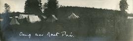
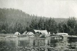
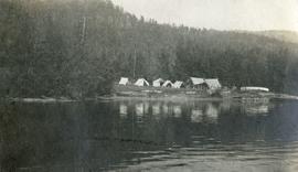
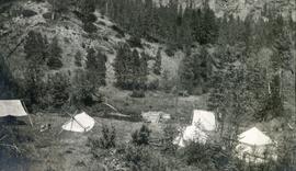
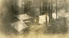
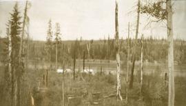
Photograph depicts canvas tents set near the banks of the Fraser River, sparse forest in the foreground, river in the middle ground and low forested hills in the background.
Photograph depicts several canvas tents set in lush vegetation near dusk.
Photograph depicts two men standing beside a canvas tent. There are two tents to the left in the midground and sparsely forested hills and low mountains in the background.
Photograph depicts three tents set between a road and a fence. There is a power pole on the right, sparsely forested hills and rocky mountains in the background.
Photograph depicts a cluster of canvas tents on the shores of an inland lake. Wood smoke from the camp disperses amongst the trees in the background. Lily pads dot the lake in the foreground.
Photograph depicts a view from the water looking at a camp with several canvas tents. Lily pads in the foreground, forest in the background.
Photograph depicts a view from the water looking toward a cluster of canvas tents set on the shores of Christina Lake.
Photograph depicts roughly cleared land in the foreground, canvas tents and a wagon in the midground, lake and hills in the background.
Photograph depicts looking down on several canvas tents set near a creek. A sparsely forested hillside in the background.
Photograph depicts canvas tents placed among the trees. The forest floor is littered with branches, wood smoke or fog disperses among the trees.
Image depicts a camp of people with Mt. Robson and the Berg Glacier in the background.
Image depicts a camp and what is likely Mt. Robson in the background.
Image depicts an unknown individual eating in a camp somewhere in South Tweedsmuir Provincial Park.
Image depicts a campsite somewhere near Berg Lake.
Image depicts group of people at a camp somewhere in Mt. Robson Provincial Park.
Image depicts a camp on the shore of a lake in South Tweedsmuir Provincial Park. The man sitting in the bottom right corner is possibly Kent Sedgwick.
Image depicts a group of individuals at camp somewhere in Mt. Robson Provincial Park.
Photograph depicts sternwheeler being towed by smaller vessel, shore in background.
Handwritten photo caption beside image reads: "Caledonia".
Buildings visible on hillside in background, pier in foreground. Photo believed to have been taken at Port Simpson, B.C.
Photograph depicts a rustic log cabin, shed and garden fence near the edge of a lake. The surrounding landscape is low rolling hills.
Image depicts a cabin at an uncertain location.
Image depicts the welcome sign in Burns Lake, B.C.
Image depicts a stretch of road somewhere at Burns Lake, B.C.
Image depicts Burns Lake, B.C.
Photograph depicts a snow covered cemetery with gravestones, tombstones, and monuments.
Image depicts bunkhouse, restaurant and store in Sinclair Mills, B.C. Map coordinates 54°01'17.4"N 121°40'53.0"W
Image depicts the upper end of the Bullion Pit in Likely, B.C.
Image depicts an old, half-collapsed house in Likely, B.C.. The slide labels it as "Bullion house."
Item is a photograph of a bulldozer removing debris from train tracks on August 27, 1956 location unknown.
Bulldozer visible to left of road in distance, mountain in background.
Image depicts a stretch of road through the Bulkley Valley.
Image depicts a section of forest in the Bulkley Valley.
Image depicts a view of Bulkley Valley.
Colour-coded map depicts lands surveyed as alienated, available for purchase or lease under Taxation Act, or reserved. Depicts land district boundaries, land recording divisions, triangulation stations, telegraph/telephone lines, communities, bodies of water, and transport routes.
Photograph depicts a view looking down on the Bulkley River, forested banks on both sides of the river, high mountains in the distance.
Image depicts the Bulkley River near Moricetown, B.C.
Image depicts numerous unknown individuals standing by the Bulkley River near Moricetown, B.C.
Image depicts a small group of people standing near the Bulkley River at Moricetown, B.C.
Image depicts the Bulkley River.
Photograph depicts buildings looking north of the Empress Hotel on Douglas Street in Victoria, BC. The Belmont is on the right and the Customs Building on the left.
Image depicts a row of buildings in Upper Fraser, B.C. with the store (titled "Paradise") with a Pepsi sign. Map coordinates 54°07'09.1"N 121°56'47.0"W
Image depicts several old buildings in a field, one of which has a caved-in roof, in Newlands, B.C. Map coordinates 54°06'28.2"N 122°12'01.0"W
Photograph depicts two large buildings across street in foreground, van visible on left.
Image depicts numerous buildings and a dock on the shore of Haida Gwaii, B.C..