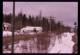
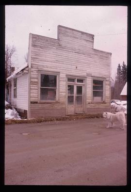
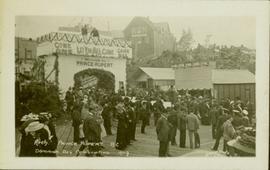
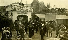
Image depicts an old barn located at a dairy farm somewhere near Dunlevy Creek in the Dawson Creek area.
Image depicts an old barn located somewhere near Dunlevy Creek in the Dawson Creek area.
Photograph depicts large dry rock storage building in foreground on right, mill on left behind tailings pile, and dryer building in centre behind conveyor belt connecting mill to dry rock storage. A cloud can be seen rising from plantsite. Trees and Troutline Creek cross foreground, mine valley and mountains visible in background. Stamped annotation on recto of photograph: "ANSCO PRINTON Munshaw Colour Service Ltd. MAR 10 1955".
Photograph depicts large dry rock storage building in foreground on left, mill in background, dryer building in right midground. Miscellaneous supplies in far right foreground, mountains visible in background. Handwritten annotation on verso of photograph: "Sept 1954". This photograph was originally stored inside duotang labeled "CASSIAR ASBESTOS CORPORATION LIMITED PHOTOGRAPHS 1954"; photo caption beneath this image: "40,000 Ton Dry Storage Building / Mill / Dryer Building".
Photograph depicts large dry rock storage building on left, mill in background, dryer building on far right. Road and power poles cross foreground, mountains stand in background. Photo caption next to printed copy of image in 1953 Annual Report: "Completed dry rock storage and dryer buildings."
Photograph depicts buildings visible through clearing in trees. Water crosses foreground, hills visible in background.
Handwritten annotation on verso reads: "Dry dock / Prince Rupert B.C."
Ground level view of the dry dock in Prince Rupert, BC. Printed annotation on recto reads: "$3,000,000 Dry Dock and Shipbuilding Plant, Prince Rupert B.C." Handwritten annotation on verso reads: "With much love. To Many from Raha[??]."
Photograph depicts the completely rebuilt drug store in Barkerville based on historical sketches and photos.
Photograph depicts three men standing in front of drugstore, and a woman in doorway of attached post office. Cleared area in foreground, bushes and trees in background. Handwritten annotation on verso of photograph: "Drug Store & Post Office South Fort George."
Road and lampstands in foreground, Government House in background.
Image depicts a driveway cordoned off by a red mesh material in Newlands, B.C. The address of the house is labelled 31951, and the name listed is "Fauchers." Map coordinates 54°06'47.8"N 122°08'22.4"W
Image depicts the Driftwood BCR station, possibly located near Driftwood Creek in the Driftwood Canyon Provincial Park east of Smithers, B.C.
Image depicts a number of identical buildings and vehicles at "Driftwood Creek" in the Driftwood Canyon Provincial Park.
Photograph depicts a lighthouse on a rocky shoreline with a forested area in the background. Annotation on verso of photograph states: "Driad Pt. light near Bella Bella kept by B.B. indian"
Photograph depicts a dredge working on the shoreline of a new apartment site on the south side of Coal Harbour, Vancouver, B.C. Photograph taken from Stanley Park, looking east. The Bayshore Inn Hotel is shown in the rear center.
Photograph depicts unknown man driving bulldozer in foreground. Shop area in background, numerous haul trucks and dozers throughout. Old mine garage can be seen in center behind dozer, and the mine's West Peak rises on right behind shop buildings. Mountain range in background. Handwritten annotations on recto of photograph: "Cassiar Asbestos Corporation Limited. Cassiar B.C. Mining asbestos ore elevation approx 6000 ft. above sea level. McDame mountain, Northern British Columbia"; "Toronto Set"; "D - 336"; "-4 1/2 -". What appears to be framing measurements are annotated on verso.
Photograph depicts a view of downtown Vancouver taken from the east end of False Creek at the foot of Terminal Ave. The view is looking northwest. In the middle distance on the left is the pier of a railway bridge taking the Great Northern Railway line into the city. It was demolished in about 1915-1920 when a new Great Northern station was constructed.
Street view side perspective photograph of several businesses in downtown Stewart, BC.
Street view of various buildings in Stewart, BC, covered with a heavy layer of snow. Visible businesses include "The R. Boyd Young Co." and "Stewart Land Co." Printed annotation on recto reads: "Stewart B.C. Hughes 78."
Street view of downtown Stewart, BC. Photograph shows boards propped up over the swampy area of the future road. Wood debris litters the foreground.
Photograph of several buildings down the street in Prince Rupert, including the church. Lumber pallets are littered around the buildings. Annotation on recto reads: "Prince Rupert, BC. 20.10.07."
Image depicts George St in downtown Prince George with City Hall in the background. Also visible are the Prince George Hotel and a movie theatre. Map coordinates 53°54'55.0"N 122°44'36.1"W
Image depicts George St in downtown Prince George with City Hall in the background. Also visible are the Prince George Hotel, Ming's Inn Chinese Restaurant, Fraser Stationers Ltd., Weiner King food cart, and a movie theatre. Map coordinates 53°54'55.0"N 122°44'36.1"W
Image depicts 4th Ave at Brunswick St. and the following businesses: Hart Drugs, The Yarn Barn, and Saveco. Map coordinates 53°54'59.9"N 122°44'52.9"W
Image depicts 4th Ave at Quebec St, showing the following businesses: The Yarn Barn, Golden Chalice Jewellers, Dandy Lines, Ultrasport, and Saveco. Map coordinates 53°54'58.6"N 122°44'47.5"W
Image depicts downtown Prince George taken from City Hall looking north. Map coordinates 53°54'46.2"N 122°44'43.9"W
Image depicts a view of Prince George from City Hall looking northeast with the pulp mills in the background. Map coordinates 53°54'46.3"N 122°44'41.9"W
Image depicts downtown Prince George taken from City Hall looking north. Map coordinates 53°54'46.2"N 122°44'43.9"W
Image depicts downtown Prince George taken from City Hall looking northwest. Map coordinates 53°54'46.2"N 122°44'43.9"W
Image depicts downtown Prince George, B.C.
Image depicts an aerial view of downtown Prince George, B.C.
The item is a photograph negative depicting downtown Prince George. The photograph was taken during the winter from inside City Hall. Various buildings can be seen, including the Ramada Inn.
Typed annotation on recto: "Douglas Lodge Scenes Stuart Lake, B.C." Man and woman standing with fishing gear in front of log fishing bungalows in forest. Tree trunks in foreground. It is believed that this couple may be the same two people pictured in item 2004.6.28, (possibly the Factors).
Handwritten caption beside this photo reads: "View of completed building." Large door on side of building, offering view of interior. Miscellaneous material in snowy foregrounded area: tractor equipment, steel drum, lumber etc.
Crowd is gathered for Dominion Day Parade. Decorated float can be seen in centre of street, and Hotel Prince Rupert stands in background. Printed annotation on recto reads: “Dominion Day Prince Rupert 1914 Photo W.W.W.” Handwritten message in ink on verso is addressed to “Mr. S. Smart 2550 Blackwood St Victoria B.C.”
Large crowd gathered on the street in downtown Prince Rupert. Decorations are hung around and town, and a lavishly decorated arch in the background reads "Come One Let 'Em All Come Come All. Welcome to Prince Rupert."
Large crowd gathered on the street in downtown Prince Rupert around a lavishly decorated arch which reads "Come One Let 'Em All Come Come All. Welcome to Prince Rupert." Annotation on recto reads: "Arch Prince Rupert, BC. Dominion Day Celebration 1909. Allen Photo."
Image depicts a small farm located in Dome Creek, B.C.
Image depicts the school and teacherage located in Dome Creek, B.C.
Image depicts a strangely shaped orange vehicle somewhere in Dome Creek, B.C.
Image depicts an old, unused log cabin somewhere in Dome Creek, B.C.
Image depicts a log cabin somewhere in Dome Creek, B.C.
Image depicts a small shack that became the later post office in Dome Creek, B.C.
Image depicts several houses in Dome Creek, B.C.
Image depicts a horse and a barn in Dome Creek, B.C.
Image depicts a farmhouse in Dome Creek, B.C.
Image depicts an old building that used to be a store and post office in Dome Creek, B.C.
Image depicts the community hall in Dome Creek, B.C.