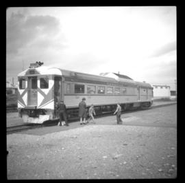
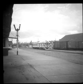
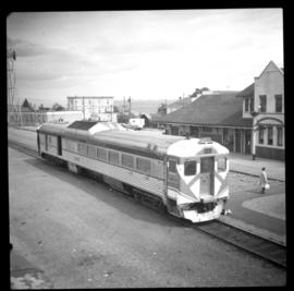
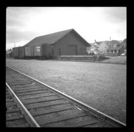
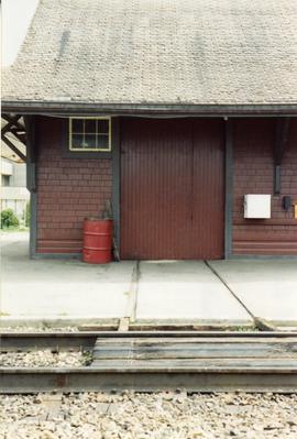
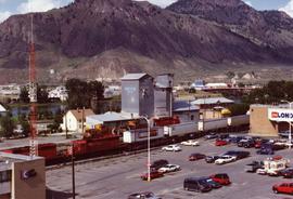
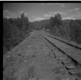
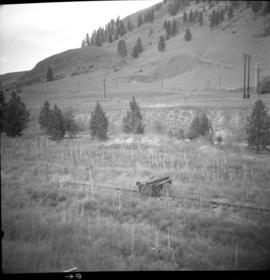
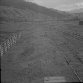
Showing 4501 results

Archival description
4049 results with digital objects Show results with digital objects
CPR Nicola branch line
2013.6.36.1.019.06 · Item · 18 Mar. 1979
Part of David Davies Railway Collection

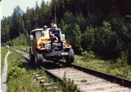
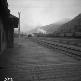
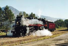
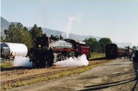
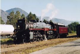
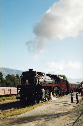
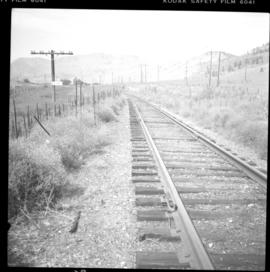
Photograph depicts the CPR Nicola branch line at Nicola, near Merritt. The view is looking south beside the stock yard. Turning "Y" used to commence at the road track at the right of the photo. The elevation is 2058 ft.

CPR Nanaimo Station
2013.6.36.1.033.08 · Item · [16 May 1970]
Part of David Davies Railway Collection

Photograph depicts the arrival of the "Dayliner," car #9023. Photograph taken looking northward and at the rear of the train. About 25 passsengers got off at this location, possibly for the May Day parade.

CPR Nanaimo Station
2013.6.36.1.033.11 · Item · [16 May 1970]
Part of David Davies Railway Collection

Photo was taken on mile 72.5. The image captures the arrival of the "Dayliner" from Victoria at 11:00 a.m., looking towards the south. About 25 passengers got off at this location, possibly for the May Day parade.

CPR Nanaimo Station
2013.6.36.1.033.12 · Item · [16 May 1970]
Part of David Davies Railway Collection

Photograph taken at mile 7.2. Arrival of the "Dayliner" at 11:00 captured. Image looking in the north east direction, with the rear of the train nearest the camera. A one way fare from Victoria to Nanaimo is $3.65 and from Nanaimo to Courtenay is $3.40.

CPR Nanaimo Station
2013.6.36.1.033.10 · Item · [16 May 1970]
Part of David Davies Railway Collection

Photograph depicts the arrival of the "Dayliner" on a trip from Victoria to Courtenay. It departs from Victoria at 11:00 a.m. About 25 passengers got off. Photograph taken looking south west.

CPR Nanaimo Depot
2013.6.36.1.033.13 · Item · [16 May 1970]
Part of David Davies Railway Collection

Photograph depicts a close up of the detail of the signals attached to the buildings station. However, it is no longer used.

CPR Nakusp looking west
2013.6.36.1.030.01 · Item · Sept. 1970
Part of David Davies Railway Collection

Photograph depicts rails shown, but also in a pile beyond the "R.H." hut. All are dated 1884, 1885, and 1886. Made variously by Barrow, Blaenaka, Dowlais and Buchum. Has one way freight per week in 1970. Nelson to Rosebury is on Monday. Rosebury to Naksup and then back to Rosebury is on Tuesday. Rosebury to Nelson is on Wednesday. CPR is said to be trying to close Rosebury to Nakusp section of 32.7 miles.

CPR Myra Canyon
2013.6.36.1.154.02 · Item · [between 1993 and 1995]
Part of David Davies Railway Collection

Photograph taken at CPR Myra Canyon. On the 'Save the Trestles' expedition after a line closure at the location.

CPR Myra Canyon
2013.6.36.1.154.04 · Item · [between 1993 and 1995]
Part of David Davies Railway Collection

Photograph taken at CPR Myra Canyon. On the 'Save the Trestles' expedition after a line closure at the location.

CPR Myra Canyon
2013.6.36.1.154.06 · Item · [between 1993 and 1995]
Part of David Davies Railway Collection

Photograph taken at CPR Myra Canyon. On the 'Save the Trestles' expedition after a line closure at the location.

CPR Myra Canyon
2013.6.36.1.154.07 · Item · [between 1993 and 1995]
Part of David Davies Railway Collection

Photograph taken at CPR Myra Canyon. On the 'Save the Trestles' expedition after a line closure at the location.

CPR Myra Canyon
2013.6.36.1.154.01 · Item · [between 1993 and 1995]
Part of David Davies Railway Collection

Photograph taken at CPR Myra Canyon. On the 'Save the Trestles' expedition after a line closure at the location.

CPR Myra Canyon
2013.6.36.1.154.03 · Item · [between 1993 and 1995]
Part of David Davies Railway Collection

Photograph taken at CPR Myra Canyon. On the 'Save the Trestles' expedition after a line closure at the location.

CPR Myra Canyon
2013.6.36.1.154.05 · Item · [between 1993 and 1995]
Part of David Davies Railway Collection

Photograph taken at CPR Myra Canyon. On the 'Save the Trestles' expedition after a line closure at the location.

CPR Myra Canyon
2013.6.36.1.154.08 · Item · [between 1993 and 1995]
Part of David Davies Railway Collection

Photograph taken at CPR Myra Canyon. On the 'Save the Trestles' expedition after a line closure at the location.

CPR "Mount Sicker" signboard
2013.6.36.1.033.01 · Item · [24 May 1967]
Part of David Davies Railway Collection

Photograph depicts a sign board that reads "Mount Sicker." Siding was located about 1 mile south of where this photograph was taken at Westholme Depot. The sign was sighted 5 miles north of Duncan, Vancouver Island. "MS" siding appeared to be taken out. This board was found in a freight shed.

CPR Mission Bridge
2013.6.36.1.017.06 · Item · [3 June 1973]
Part of David Davies Railway Collection

Photograph depicts the CPR Mission Bridge on the Huntingdon branch. The photo was taken from the open swing span looking downstream, with a tug and derrick (Fraser River Pile Driving Co.) fast disappearing downstream. The new road bridge in the background is about to be opened in late June 1973.

CPR Mission Bridge
2013.6.36.1.017.08 · Item · [3 June 1973]
Part of David Davies Railway Collection

Photograph depicts the CPR Mission Bride on the Huntingdon branch. The photo was taken from the open swing, and shows a tug and derrick passing swiftly downstream in the north channel of the opening. The span opens about every 2 or 3 days for river traffic.

CPR Mission Bridge
2013.6.36.1.017.09 · Item · [3 June 1973]
Part of David Davies Railway Collection

Photograph depicts the CPR Mission Bridge on the Huntingdon branch. The span opened to allow downstream passage of a tug and derrick, which passed at about 6 to 8 knots because of the freshet. Tow started at federal wharf at Mission City. The span opens for river traffic every 2 or 3 days. The view is looking east and upstream.

CPR Mission Bridge
2013.6.36.1.017.10 · Item · [3 June 1973]
Part of David Davies Railway Collection

Photograph depicts the CPR Mission Bridge on the Huntingdon branch. The swing span is in an open position and the view is looking west and downstream. A new road bridge to be opened within the month is in the background. The bridge cabin holds a gas engine that turns the span in about 60 seconds.

CPR Mission Bridge
2013.6.36.1.017.07 · Item · [3 June 1973]
Part of David Davies Railway Collection

Photograph depicts the CPR Mission Bridge on the Huntingdon Branch. It shows the final box span of the bridge on the south shore, as viewed from the opened swing span. The span opened for river traffic every 2 or 3 days. The view is looking south, with downstream to the right.

CPR Mission Bridge
2013.6.36.1.017.11 · Item · [3 June 1973]
Part of David Davies Railway Collection

Photograph depicts the CPR Mission Bride on the Huntingdon branch. It shows the receding view of the southbound daily way freight train at about 12:30 hrs. STD time. The train consisted of 2 locomotives, some 35 cars, and this caboose, #436733, built in 1920. The photo was taken from the swing span of the bridge.

CPR Mission Bridge
2013.6.36.1.017.02 · Item · [3 June 1973]
Part of David Davies Railway Collection

Photograph depicts the CPR Mission Bridge on the Huntingdon Branch. The view is looking north from the open swing span. The bridge is about 1700 ft. long and consists of eight 160 ft. tress spans, one 230 ft. swing span, and 3 girder spans. Seven of the eight truss spans are seen in this view, with the Fraser River in freshet.

CPR Mission Bridge
2013.6.36.1.017.03 · Item · [3 June 1973]
Part of David Davies Railway Collection

Photograph depicts the CPR Mission Bridge on the Huntingdon Branch. It shows the daily southbound way freight train at about 12:30 hours STD time, crossing the bridge. The train consisted of two locomotives, about 35 cars, and a 1920 wooden caboose. The lead locomotive was CPR 8510, GM class 0-4-4-0, built in 1954. There is a 10 mph speed restriction on the bridge.

C.P.R. Michel Station
2013.6.36.1.007.105 · Item · Oct. 1965
Part of David Davies Railway Collection

Photograph depicts the C.P.R. Michel Station between Crow's Nest and Fernie. The view is looking west towards the only working colliery left in the district. The station is disused but in good repair.

CPR line, downtown Kamloops
2013.6.36.1.104.02 · Item · [13 June 1993]
Part of David Davies Railway Collection

Photograph depicts the CPR depot and a westbiund container freight standing in the yard. Two cabooses for local way-freight and a switcher were located on the rear spur.

CPR line Vancouver
2013.6.36.1.055.37 · Item · 23 Nov. 1968
Part of David Davies Railway Collection

Photograph depicts the CPR line on Thurlow Street, Vancouver. A new spur was about to be laid next to a recently built rail ferry slip.

2013.6.36.1.016.32 · Item · [22 May 1973]
Part of David Davies Railway Collection

Photograph depicts the CPR line 3 miles south of Spences Bridge. There is a outbound freight train moving down the grade at about 11 am. A Sperry rail fault detection car had just passed in the opposite direction. Later discovered that a CN derailment north of Spences Bridge had diverted all the CN traffic to the CP tracks, which explains the slow movement of the train.

2013.6.36.1.028.10 · Item · Aug. 1983
Part of David Davies Railway Collection

Photograph depicts the CPR line at mile 126, on the outskirts of Midway. This is the end of the Boundary Subdivision and the line physically ends 3 miles west of here, at the Pope and Talbot lumber mill. The rail here is 100 lb., from 1926, and marked "O.I.E.S. Co. Ltd." The view is looking west.

2013.6.36.1.027.09 · Item · [23 June 1979]
Part of David Davies Railway Collection

Photograph depicts the CPR line at about a quarter mile south of the Carmi depot or at about mile 46.5 on the Carmi Subdivision. To the left is a disused sawmill that was once service by the railways but has since had its spur removed. The view is looking north and up the 2% grade.

CPR line near Spences Bridge
2013.6.36.1.016.29 · Item · [22 May 1973]
Part of David Davies Railway Collection

Photograph depicts the CPR line 3 miles south of Spences Bridge at road overpass. There is a Sperry rail fault detection car moving steadily up the grade at about 30mph. It did not stop at Spences Bridge. The view is looking south, downhill.

CPR line near Penticton
2013.6.36.1.024.02 · Item · [24 June 1979]
Part of David Davies Railway Collection

Photograph depicts the CPR line at about mile 129.7 or 3.5 miles north of Penticton. This section is in the Carmi Subdivision. The view is looking south and just south of the road crossing from Naramata to Penticton.

CPR line near Midway
2013.6.36.1.028.12 · Item · Aug. 1983
Part of David Davies Railway Collection

Photograph depicts the CPR line near Midway, at the western end of the Boundary Subdivision. This points is 2.4 miles west of the Midway depot and denoted by a dump of ties laid on the rails. West of here was the Carmi Subdivision to Penticton (134 miles), which was lifted in two parts in 1979 and 1980.

CPR line near Merritt
2013.6.36.1.019.03 · Item · [26 May 1973]
Part of David Davies Railway Collection

Photograph depicts the CPR line near Merritt. The way freight from Spences Bridge to Merritt is about 1 west of Dot, which is mile 20.3 from Spences Bridge. It is a 20 car train. The view is looking east.