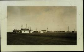
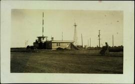
Showing 4258 results

Archival description
3217 results with digital objects Show results with digital objects
Granduc Townsite
2012.13.1.83.04 · Item · 1979
Part of J. Kent Sedgwick fonds

Image depicts a row of houses in Granduc, near the Granduc Mine and located north of Stewart, B.C.

2006.20.12.9 · Item · [ca. 1940]
Part of Northern BC Archives Historical Photograph Collection

Photograph depicts group of buildings at Grande Prairie airstrip. The foremost building has the sign "YUKON SOUTHERN" on its roof, and the tower and admin building can be seen behind. Power poles, large trucks, and other large unidentified machinery are lined up in background on right.

Royal Canadian Air Force
2006.20.12.8 · Item · [ca. 1940]
Part of Northern BC Archives Historical Photograph Collection

Photograph depicts building with small second story attached, and a tall red and white pole in front. Signal tower and power poles in background on right, semi-trailer in background on left. A man in uniform can be seen in the far right sitting on a small staircase on wheels. Small unidentified buildings and miscellaneous shop supplies in background. Handwritten photo album caption beside this photo reads: "Grand Prairie Tower and Adm. Bldg."

Royal Canadian Air Force
2012.13.2.15.20.02 · Item · 18 Apr. 2001
Part of J. Kent Sedgwick fonds

The photograph depicts an old Grand Trunk Pacific train station West of Entwistle on Highway 16 West. The station is white with a brown roof and brick chimney. Annotation on reverse side of photograph states, "6 km west from Entwistle on the south side of HWY 16 W, Alberta, 2001-04-17."

2012.13.2.15.20.01 · Item · 16 Apr. 1991
Part of J. Kent Sedgwick fonds

The photograph depicts an old Grand Trunk Pacific train station on Highway 16, West of Edmonton. The train station is white with a dark roof. Annotation on reverse side of photograph states, "on HWY #16, West of Edmonton 1991-04-16."

Grand Forks CPR depot
2013.6.36.1.028.04 · Item · Aug. 1983
Part of David Davies Railway Collection

Photograph depicts the Grand Forks CPR depot, located at mile 94.8 on the Boundary Subdivision, which runs from Nelson to Midway (127 miles). It was originally built by the Columbia & Western Railway in 1899. IT has not seen a passenger train in years but it is still in use for administrative purposes.

2013.6.36.1.002.043 · Item · [July 1965]
Part of David Davies Railway Collection

Photograph depicts the Grand Central Hotel at the intersection of Marpole Ave and Hudson St. in south Vancouver. The hotel was built in 1912 by J.J. Graver and run from 1913-1915. It re-opened in 1920 as a home for incurables (veterans). In 1937 it became the provincial infirmary and closed in May 1965.

Grain elevator at Wynndel
2013.6.36.1.028.05 · Item · Aug. 1983
Part of David Davies Railway Collection

Photograph depicts the a grain elevator at Wynndel, located at mile 73.8 on the CPR line on the Nelson Subdivision. It is between Creston at mile 67.2 and Kootenay Landing at mile 83.1. Grain elevators are rare in BC and this one belongs to the United Grain Growers. The view is looking east.

Grain Elevator and Dock
2012.13.1.77.35 · Item · 1980
Part of J. Kent Sedgwick fonds

Image depicts a large vessel docked at a grain elevator and two smaller boats at a dock in the foreground somewhere in Prince Rupert, B.C.

2011.3.2.06 · Item · [ca. 1910]
Part of North Coast & Central BC Postcard Collection

Photo of buildings behind street, fenced on either side. Man and horse can be seen on street. Printed annotation on verso reads: “The Government buildings Fort George B. C.” Handwritten annotation on recto reads: “This is the place I receive my patent from next June.”

Goat River railway station
2012.13.2.15.23.2 · Item · 2010
Part of J. Kent Sedgwick fonds

The photograph depicts the Goat River railway station next to twinned rails. The station is abandoned with missing doors and windows. Annotation on card states, "GOAT RIVER RAILWAY STATION." Photograph is a reproduction from [ca. 1978].

Goat River railway station
2012.13.2.15.23.3 · Item · 2010
Part of J. Kent Sedgwick fonds

The photograph depicts the Goat River railway station next to twinned rails. The station is abandoned with missing doors and windows. Annotation on reverse side of photograph states, "Goat River GTP Station c. 1978 maybe 1982. photo by J. Kent Sedgwick." The statement, "Geo Info Services" is crossed out. Photograph is a reproduction from [ca. 1978].

Goat River railway station
2012.13.2.15.23.4 · Item · 2010
Part of J. Kent Sedgwick fonds

The photograph depicts the Goat River railway station next to twinned rails. The station is abandoned with missing doors and windows. The number 4 is written on the photograph in marker and circled. Annotation on reverse side of photograph states, "Photo Credit J. K. Sedgwick Goat River, c. 1978."

Glenwalker Ranch
2013.6.36.1.078.01 · Item · [13 May 1979]
Part of David Davies Railway Collection

Photograph depicts Glenwalker Ranch. Visible are details of the log construction of a barn that was built between 1890 and 1910.

Giscome Street Scene
2012.13.1.87.173 · Item · [between 1975 and 1995]
Part of J. Kent Sedgwick fonds

Image depicts a street in Giscome B.C. The Giscome Store is located on the left side of the image with the church in the background. Map coordinates 54°04'18.5"N 122°21'57.7"W

Giscome Station
2012.13.1.6.034 · Item · May 1975
Part of J. Kent Sedgwick fonds

Image depicts the old Giscome Train Station in Giscome, B.C. It was demolished between 1976 and 1977.

2011.12.09 · Item · [ca. September 1950- June 1951]
Part of Giscome, BC Historical Photograph collection

Street view featuring a dirt road leading directly to Giscome School, a three room institution. On the right the steeple of the Catholic church is visible, beside which was Neff’s (sp?) corner store. Handwritten annotation in pen on verso reads: “Looking up our street. The school is at the end.”

Giscome School - Before
2012.13.1.87.084 · Item · [between 1980 and 2000?]
Part of J. Kent Sedgwick fonds

Image depicts the Giscome mill site in Giscome, B.C. The bunkhouse is in the background on the left and the school is in the foreground on the right. Map coordinates 54°04'04.8"N 122°22'04.7"W

Giscome School - After
2012.13.1.87.085 · Item · [between 1975 and 1995]
Part of J. Kent Sedgwick fonds

Image depicts the Giscome mill site in Giscome, B.C. The bunkhouse is no longer there and the school is in the foreground on the right. Map coordinates 54°04'04.8"N 122°22'04.7"W

Giscome Sawmill
2012.13.1.87.167 · Item · [between 1975 and 1995]
Part of J. Kent Sedgwick fonds

Image depicts the mill site at Giscome, B.C. Map coordinates 54°04'19.7"N 122°22'04.7"W

Giscome Sawmill
2012.13.1.87.171 · Item · [between 1975 and 1995]
Part of J. Kent Sedgwick fonds

Image depicts the mill site at Giscome, B.C. A sign in the foreground reads "Maynard's Industrial Auctioneers." Map coordinates 54°04'19.7"N 122°22'04.7"W

Giscome Sawmill
2012.13.1.87.168 · Item · [between 1975 and 1995]
Part of J. Kent Sedgwick fonds

Image depicts the mill site at Giscome, B.C. Map coordinates 54°04'19.7"N 122°22'04.7"W

Giscome Sawmill
2012.13.1.87.170 · Item · [between 1975 and 1995]
Part of J. Kent Sedgwick fonds

Image depicts the mill site at Giscome, B.C. Map coordinates 54°04'19.7"N 122°22'04.7"W

Giscome Sawmill
2012.13.1.87.176 · Item · [between 1975 and 1995]
Part of J. Kent Sedgwick fonds

Image depicts the Giscome, B.C. mill site looking west. Map coordinates 54°04'18.5"N 122°21'57.7"W

Giscome Sawmill
2012.13.1.87.169 · Item · [between 1975 and 1995]
Part of J. Kent Sedgwick fonds

Image depicts the mill site at Giscome and its beehive burner. Map coordinates 54°04'19.7"N 122°22'04.7"W

Giscome Quarry
2012.13.1.87.074 · Item · [between 1975 and 1995]
Part of J. Kent Sedgwick fonds

Image depicts what is possibly the quarry located at Eaglet Lake in Giscome, B.C.

2009.5.3.150 · Item · [ca. 1910]
Part of Taylor-Baxter Family Photograph Collection

Photograph depicts people on river shore, and boat and buildings in midground. River bank in foreground, forest in background. Handwritten annotation on verso of photograph: "Giscombe Portage Fraser River", on recto: "Huble & Seaback on Fraser River."