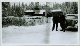
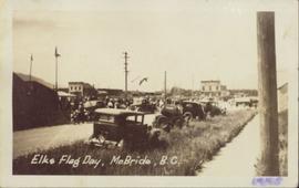
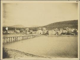
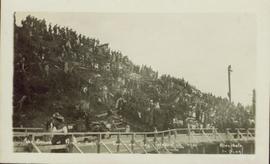
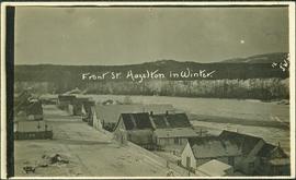
Handwritten annotation on recto of photograph: "Front St. Hazelton in Winter. 12 J.W. [...]" Tree line, field, and hills in background. Handwritten annotation on verso of photograph: "Miss. Nellie [Nelville] G. Caranaugh".
Photograph depicts two unidentified woman standing in front of tall plant in mall. Photo believed to have been taken in Newton, B.C.
Handwritten caption beside this photo reads: "Fred Youngstrom & Kitchen Staff. 1946." Photograph depicts Fred standing to right of three woman, a young girl, and a dog. The group is standing on the snow-covered front steps of a (kitchen?) building, lumber pile on far right. A large metal triangle is hanging behind Fred. It is believed that this photograph was taken at the camp at Summit Lake B.C. (see item 2005.3.57).
Handwritten caption above this photo reads: "Fred Youngstrom in [church shirt?]" Photograph depicts two men (Fred on left) standing on snow-covered road in front of car with a British Columbia license plate "93-650". A wood pile and long building with porch can be seen in background in front of forest trees. It is believed that this photo was taken at the camp in Summit Lake, B.C. (see item 2005.3.57).
Two unidentified men stand in background.
Handwritten annotations on verso read: “Oct 2/1992, Faculty of Management, University of Calgary, Frank King and Iona Campagnolo,” and “from Calgary ’88 Friends”.
Men stand wearing vests and ties in doorway framed in corner of building with the sign: "R. CUNNINGHAM LTD. GENERAL MERCHANDISE." Various other advertisements hang from doorway. Man on left believed to be transport driver also featured in items 2009.5.1.80 & 2009.5.1.81. Handwritten annotation on recto of photograph: "Hazelton, B.C. 1910".
Six men stand on boardwalk in front of theatre.
Photograph depicts the early settlement of Fort George. The buildings to the left of the fence are believed to be owned by the Hudson's Bay Company. The land to the right of the fence belonged to the Fort George Reserve, the home of today's Lheidli T'enneh Band who relocated to a reserve at Shelley when this reserve was sold in 1912. Handwritten annotation on verso and recto of this photograph reads: "Fort George from opposite side of Fraser River".
Footage includes salmon jumping in a river, men filleting fish in fishing boat in tide water, a beaver in the water, and a bird, probably a heron, flying.
Recordings from the boat on a river, some loons on a lake, either Anahim or Fenton lake, and a panoramic view of the lake with mountains in background.
Also some footage of men fishing from the shore of a river, children catching fish, children swimming, some river rapids, footage of an eagle, a pelican on the lake, a group of birds, probably sand pipers, in water.
There are two young girls playing on a boat near shore, a view of white and brown house, and an older boy pulling a young girl in a wagon.
Include is footage of a backyard BBQ picnic, two young girls fishing, a cabin at a lake, and general scenery of birch trees, a boat house, and a dock at lake.
There is also a sign that reads "Breezy Cove," people relaxing on porch in front of cabin, and footage of a woman believed to be Mrs. Elsey and a friend walking on a forest path.
The film ends with footage of more fishing off a motor boat and unloading the motor boat at a dock.
Possible locations of the filming include the Bella Coola River, the Bella Coola Valley, the Bulkley Valley, the Hagensborg area, and Nimpo Lake.
Footage of thee men in dugout canoe bringing in ooligan nets full of ooligan fish on what is believed to be the Bella Coola river. Two of the men bring in the net while the third bails water. The men then bring in the canoe to shore using long poles. Women then join and help transport the fish to shore and then place the fish in large "stink box" where they are stirred with a stick.
Begins with footage of maps of the Bella Coola area, Tweedsmuir Park, and Wells Gray Park. Then there is a title slide that reads "Steelhead Unlimited on the Bella Cover River". There is general scenery footage of mountains, streams, rivers, a black bear, a white robin, Eagles.
Footage of men floating down minor river rapids in a rubber boats the men banking their boat and fishing from shore.
Footage of Ooligan fishing and processing : paddling the long dugout canoe with the nets in the water, hauling the fish to shore, placing them in "stink boxes" to extract the grease, and wrapping up the nets .
Possible locations of the footage is Bella Coola, Bella Bella, Bella Coola River, Dean River, Chilcotin region, Tweedsmuir Provincial Park or Wells Gray Park.
Footage of fly fishing on a river, possibly the Bella Coola River or Dean River, fishing in river canyon, footage of deer, footage of Alert Bay, village, marina and totem poles on shore, footage of a white robin, and a woman holding her salmon catch. Also include is recordings of the Anahim stampede and the bucking bronco event.
The first portion of the film begins with a map of Tweedsmuir Provincial Park and then cuts to a motor boat on a lake, possibly Fenton Lake, and men fishing on the lake. The next clip is of more men fly-fishing on a river, possibly the Bella Coola River or the Dean River. A short clip follows of two children in a boat with a man pushing them along with a rod. There is footage of the scenic landscape, which is most likely the Bella Coola Valley, and a cabin, which is believed to be Elsey's. A woman believed to be Mrs. Elsey sits on the porch and then arranges her flowers. The film shows some ducks on the lake, two squirrels playing and the Elsey's dog in a boat. Mrs. Elsey pulls the boat ashore in the next clip and then the film shows her working in her vegetable garden. There is more scenic filming of the valley and a man cutting down a tree with a chain saw. There is footage of a grouse beating it's wings, chipmunk looking for seeds, birds in a marsh, three moose in a marsh, and a bald eagle perched and flying.
There is a break in the film and the second portion begins with footage of cabin in the mountains, a baby in a cradle, an elder First Nations woman, and a gathering of First Nations peoples by a tent. There is a shot of a picnic site sign labelled "Burnt Bridge Picnic site Parks Branch" and another sign that reads "Kalyskt Creek." There is then footage of the creek and a truck driving down a dirt road. There is then a group of people boarding a motor boat in a river and driving up and down the river, which could possibly be the Dean River or the Bella Coola River. There is then more filming of a cabin in the mountains, possibly Elsey's, and a man cleaning a large fish he caught. Then there is footage of men in a rubber raft floating down a river and fishing from the raft, and then some other men traveling in a motor boat.
There is an another break and the third portion of the film begins with footage of birds on a lake and footage from a boat showing the mountains. On land there is filming of two bears walking, men hunting the bear, killing the bear, and skinning the bear. The film cuts back to the boat and the filming the mountains along the water. The people on the boat then pull up crab traps from the water and cook the crabs on the boat. The film ends with footage of salmon jumping and a man filleting his fish catch.
Photograph depicts lane in front of tent buildings flooded with water, forest trees in background. Photograph taken from canoe, portion of canoe visible in foreground. It is believed that this photograph may depict the Island Cache in flood, at Prince George, BC.
Photograph depicts lane in front of tent buildings flooded with water. Tree in midground, forest trees in background. A man can be seen between first and second row of tent buildings. Photograph taken from canoe, portion of canoe visible in right foreground. It is believed that this photograph may depict the Island Cache in flood, at Prince George, BC.
Photograph depicts two men in a row boat, one rowing and one holding a peugh (J.J. Claxton) and watching the catch being reeled in on the fishing pole of another man wearing a hospital gown. A small boy on the deck watches. Handwritten annotation in pencil on verso reads: “JJC x”
Photograph of a large crowd gathered in front of a Grand Trunk Pacific train. Residential buildings atop a hill are visible in the background. Annotation on recto reads: "First Train Leaving Prince Rupert June 14 1911"
Photograph of a mustachioed man perched atop a cart load of lumber hitched to a team of horses. Annotation on recto reads: "First Team Hitched Up at Prince Rupert May 1908."
Rocky shoreline featuring a small dwelling, totem pole, net rack, canoes pulled up to shore, barrels and boxes and a tent.
Handwritten annotation in pencil on verso reads: “Kunhalas [sic] at entrance to C--- Harbour”.
Photograph depicts a man and woman standing on steps to a round tower in fenced area. Roofs of other buildings can be seen below on right; water and shore visible in background.
Printed on image: "Indian Jail, Metlatkla".
Image depicts a street, possibly in Kamloops, which has been closed for a Sunday morning Farmer's Market.
Typed annotation on recto: "The Factor's Home H.B.Co. Post Fort St. James, Stuart Lake, B.C." Man and woman stand formally attired in front of small, square, white house. Log fence and tree-covered hillside in background.
Photograph depicts a group of nine men holding a flag and banner that states: "The Epworth League of The Methodist Church of Canada." Annotation on verso of photograph states: "Epworth League Officers Port Simpson This is a fair sample of the "shots" I made"
Sign in foreground reads: “Stop Bull Shitting, [Phoney (crossed out)] Ioney”.
Handwritten annotation on verso reads: “The Kitimat Oil Port Environmental Lobby, didn’t believe I killed it. I did!”
Semi-visible sign reads: “Supertanks - Pipelines S.O.S.”
Photograph depicts crowd with individuals holding protest signs.
Photograph of several vehicles parked along a road. A large crowd is visible gathering in the background. Printed annotation on recto reads: "Elks Flag Day, McBride, B.C." Handwritten annotation on verso reads: "Jan. 5th 1945. Dear Dad, Am working in a lumber camp, advised by Prof. Johnson and Prof Casey. Altitude about 2,300. Think I will like it, if they don't make me work to[sic] heavy. the Climate and the grub is swell. Otherwise not so hot. Bye for now. Love Will." Postcard is addressed: "To: Mr. A.W. Hockin Big Valley, Alberta. From. W. Hockin c/o E.U. Lamming McBride, B.C."
Four women sit in foreground at a porch partially covered with foliage.
Handwritten annotations on verso read: "Honoured elders of porch of Mission House at Kincolith, Nass River"; "sun set or legend of the past".
Handwritten annotation on verso reads: "A very old Tsimpsion women - said to be over 110 yrs old."
Photograph depicts town buildings on opposite shore. Beach and dock can be seen in foreground.
Handwritten annotation on verso reads: "Chapter XXII, No 1. Eastern Section of Port Simpson as christianized."
Photograph depicts unidentified individual and cars on street in foreground, snow banks, trees, and power poles on either side. Buildings can be seen on far right, mountains visible in background. Handwritten annotation on recto of photograph: "townsite Looking East".
Row of buildings with path and poles. Rough cleared land in foreground, men visible in far left background.
Footage of eagles flying, a close up of a fish on display, men fishing cutthroat trout, fly-fishing on river, and tying mill eggs with nylon mesh.
Possible locations of filming include the Bella Coola River and Dean River.
Crowd is gathered for Dominion Day Parade. Decorated float can be seen in centre of street, and Hotel Prince Rupert stands in background. Printed annotation on recto reads: “Dominion Day Prince Rupert 1914 Photo W.W.W.” Handwritten message in ink on verso is addressed to “Mr. S. Smart 2550 Blackwood St Victoria B.C.”
Photograph depicts an event on Lillooet Main Street with spectator crowds. The Union Jack and Canadian Red Ensign flags suggest this may be a Dominion Day event. The Lillooet community put on large, multi-day Dominion Day events between 1912 and 1916 with many planned activities. The particular activity depicted in this photograph may be a horse race or rodeo-type event. Main Street businesses visible include the Lillooet Restaurant, the Lillooet Pool Hall, and the "OK" Baths.
Photograph depicts an event on Lillooet Main Street with spectator crowds. The Union Jack and Canadian Red Ensign flags suggest this may be a Dominion Day event. The Lillooet community put on large, multi-day Dominion Day events between 1912 and 1916 with many planned activities. The particular activity depicted in this photograph appears to be a horse race event. Main Street businesses visible include the Lillooet Restaurant and the "C.A. Phair General Merchant" store.
Large crowd gathered on the street in downtown Prince Rupert. Decorations are hung around and town, and a lavishly decorated arch in the background reads "Come One Let 'Em All Come Come All. Welcome to Prince Rupert."
Photograph of a large crowd in formal wear gathered on a slope. Some spectators can be seen perched atop extremely high poles. Annotation on recto reads: "The Crowd at Prince Rupert's Dominion Day Celebration 1909. Allen Photo 1-7-09."
Large crowd gathered on the street in downtown Prince Rupert around a lavishly decorated arch which reads "Come One Let 'Em All Come Come All. Welcome to Prince Rupert." Annotation on recto reads: "Arch Prince Rupert, BC. Dominion Day Celebration 1909. Allen Photo."
Image depicts the community hall in Dome Creek, B.C.
Photograph depicting a dog laying in the grass in someone's backyard of a personal residence.
View of dock full of rows of nets and a few workers. Sail boats are anchored near the dock and there are rows of bunkhouses in the mid ground, trees in the background. Handwritten annotation in pencil on recto reads: “Port Essington B. C.”
Photograph depicts settlement across frozen lake. Trees cross midground, mountains stand in background. Handwritten annotation on verso of photograph reads: "Distant view of Tete Jaune B.C.", on recto of photograph: "I marked about where you loaded your boat the telephone pole is down the road toward 53. Tete Jaune Mile 52."
Photograph features Terrace Gardens.
Photograph depicting a dirt road winding between grass and trees in Soda Creek.
Photograph depicting a dirt field surrounded by green trees.