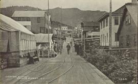
Street view down Centre Street in Prince Rupert, BC. Printed annotation on recto reads: "Centre Street, Prince Rupert, B.C. 1664." Handwritten annotation on verso reads: "Minnie sent a parcel to you by express to-day- some things you left behind you. I hope you and Bertie had a good trip up. Florrie and the children will leave on the morning train. All are pretty well and send their love to you. Harrie." Postcard is addressed to: "Miss M.V. Beattie Enderby, B.C." Verso is affixed with a two cent Canadian stamp. Postmarkson recto and verso are illegible.
Photograph is a printed postcard depicting a wagon track between buildings situated on either side. There are mountains in the back ground. Possibly Stewart, BC.
The item is a photograph of a street view looking west down 3rd Avenue Prince George. The Brick, Liquidation World, the TD building and other commercial businesses are visible.
The item is a photograph of a street view looking west down 3rd Avenue, Prince George. Royal Dry Cleaners, the TD building and other various commercial businesses are visible.
The item is a photograph of a street view looking west down 3rd Avenue Prince George. The TD building and various other commercial businesses are visible.
The item is a photograph of a street view looking east down 3rd Avenue Prince George. Various commercial businesses are visible.
The item is a photograph of a street view looking east down 3rd Avenue Prince George. The Brick, Liquidation World, Home Hardware and various other commercial businesses are visible.
The item is a photograph of a street view looking east down 3rd Avenue from Dominion Street in Prince George. Various commercial businesses are visible.
This photographic reproduction from the BC Provincial Archives is captioned: "Prince George District - Another 'town' - Mile 129, BC - Summer 1913". In August 1913, Foley, Welch and Stuart, railway contractors, moved their distribution depot from Tete Jaune to Mile 129, in the vicinity of present day Loos, BC.
Wales, Great Britain
Image depicts a street of houses somewhere in Prince George, B.C.
Photograph depicts a street lamp on a wooden deck with barrels and a canvas-covered building in the background.
Photograph depicts four men and small cart standing in street, lines of log buildings on either side. Tents can be seen at end of left side of street. First building on left is larger, with the sign "STOPPING PLACE". Trees cross midground, mountains stand in background. Handwritten annotation on verso of photograph reads: "Tete Jaune Cache. B.C."
Street scene in Prince George B.C. Several Union Jack flags are visible and there is a celebration banner at the end of the street. Long shadows in photo indicate summer (perhaps Dominion Day?). River in foreground, railroad and city in mid ground and hill in background. Printed annotation on recto reads: “Prince George. B.C.”
Image depicts a street in Giscome B.C. The Giscome Store is located on the left side of the image with the church in the background. Map coordinates 54°04'18.5"N 122°21'57.7"W
Image depicts a street in Giscome. The store was previously located on the left. The church is in the background. Map coordinates 54°04'18.5"N 122°21'57.7"W
Photograph depicts view of street showing that a large hill of rock has been cut through to allow for construction of roadway.
View of the road descending to the waterfront. Buildings and forested area are visible on either side of street. Annotation on recto reads: "Prince Rupert BC. '07."
Photograph depicts former street car tracks in New Westminster.
Photograph depicts a street car body that formerly belonged to Vancouver, but was found by Davies in Penticton.
Clouds reflected in stream, willows growing from bed of snow
Riparian grasses
Photograph depicts a stream, forest and buildings. Location is not named.
Small island bearing vegetation surrounded by shallow streams, Nunavut
Image depicts a small stream running through a cluster of trees somewhere in or around Seton Portage, B.C.
Unidentified riparian bush in autumnal foliage
Shoreline stand of trees along the bend of a frozen river and its emerging stream
Spring thaw on the Nechako River, Prince George, British Columbia
Image depicts a small stream somewhere on Cottonwood Island.
Photograph depicts a stream bed surrounded by forest. One person is walking on the stream bed.
Photograph depicts a stream and forest.
Photograph depicts a view from above, looking down on a stream with forest on both sides.
Photograph depicts a stream with a rocky bank surrounded by forest.
Image depicts a stream somewhere along the White Pass railway.
Image depicts a downhill stream somewhere in the area surrounding Stewart, B.C.
Habit of <i>Chenopodium capitatum</i> in fruit, Northwest Territories
Image depicts a view of the Dunkley Lumber Mill in Strathnaver, B.C.
Image depicts the BCR, as well as the Dunkley Lumber Mill, in Strathnaver, B.C.
Image depicts what is likely the Dunkley Lumber Mill in Strathnaver, B.C.
Image depicts an aerial view of Strathnaver, B.C.
Igneous rock formations in foreground and ice flows in background, Nunavut