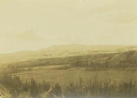
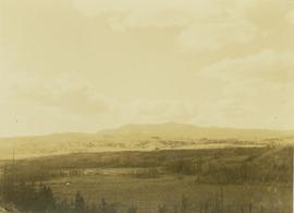
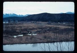
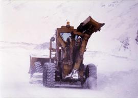
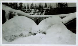
Photograph depicts wheel bulldozer in snowy unknown area of mine.
Photograph depicts part of the vacuum dust control and removal system in the Cassiar mill building. Unidentified man can be seen at rotary air-lock, in which heavy blown dust would collect before dropping to plenum conveyor resting just above floor. From here, the dust would eventually be expelled at the tailings pile outside of the mill. Second unidentified man can be seen climbing steps in background. This section of the mill was located above the lab.
Photograph depicts Zora Ivanovska in safety gear, vaccuming asbestos dust from "hall screen" in mill (slanted vibrating tables with varying mesh sizes, used to separate different lengths of fibre). Mill General Foreman Tony Pinto is visible on far right, with unidentified man.
Image depicts what appears to be a small community on the shore of a lake. The location is uncertain.
Photograph depicts framework of one side of the crusher building next to rocks from excavated mountain wall. Lumber in foreground. Handwritten caption beside this photo reads: "Note confined area to work in, and need for rock fences."
Image depicts a construction area somewhere in Tumbler Ridge, B.C.
Slide depicts a detonation in an area of cleared ground in a forested area, likely the Aleza Lake Experiment Station. Work may have been undertaken for roadbuilding activities at the Experiment Station.
Photograph depicts yellow conveyor belt in foreground over gravel pit, dump truck behind in midground. Mountains visible in background. Photo speculated to have been taken at the plant or near the Cassiar airstrip. Stamped annotation on recto of photograph: "JUN. 1987".
Handwritten caption beside this photo reads: "Cookhouse in Winter". Photograph depicts top of building semi-visible behind large snow pile. Treetops can be seen in background.
Image depicts a view of a river from the Cottonwood Bridge.
Image depicts a forest; the image is possibly taken from somewhere near the Cottonwood Rail Road Bridge.
Image depicts the Cottonwood Canyon.
Image depicts a section of the Heritage Trail on Cottonwood Island in Prince George, B.C.
Image depicts the Cottonwood House Historic Site along Barkerville Highway, east of Quesnel, B.C. A sign posted by the fence reads: "For over half a century the Boyd family operated this haven for man and beast. Here weary travellers found lodging, food, and drink. Here fresh horses were hitched to stage-coaches and miners bought supplies. This historic road-house, built in 1864, stood as an oasis of civilization on the frontier of a rich new land."
Image depicts Cottonwood Island.
Image depicts a nature trail in Cottonwood Island Park by a beehive burner. Map coordinates 53°55'23.6"N 122°43'53.8"W
Image depicts a couple walking through a nature trail in Cottonwood Island Park. Map coordinates 53°55'23.6"N 122°43'53.8"W
Image depicts a crowd of people in Cottonwood Park in Prince George, B.C.
Image depicts a the Cottonwood Island Nature Park sign and map in Prince George, B.C.
Photograph depicts large bridge and dam over a wide river, industrial structures throughout. Hills on opposite shore in background. Handwritten annotation on recto of photograph: "Coulee Dam, This is were[sic] I went this fall. Wished you had of been with me."
Photograph depicts open field with dark clouds overhead. Cow grazing in left, forest in background.
Photograph of the SS "Princess Charlotte" on the open ocean. Metallic annotation on recto reads: "C.P.R.SS Princess Charlotte entered according to act of the parliament of Canada, in the year 1908[?]. by A. Shaw, at the Department of Agriculture." Printed annotation on verso reads "Shaw & Co., Photo. Victoria. B.C. (Empire Series)"
Photograph depicts a craggy mountain peak covered with coniferous trees and snow.
Photograph depicts lumber and brush piles, forest in background. Crane semi-visible on left, small boat semi-visible on right.
Handwritten photo captions below this item and item 2000.1.1.2.324: "ELEVATION OF SITE: 6000' " "Two views of completed Crusher Bldg." Crane numbered "151" stands above and to right of crusher building. Snowdrift in foreground, mountain range in background.
Photograph depicts the load and main hook block of a dragline crane operating in excavation area of forest.
Image depicts a creek near Quesnelle Forks, B.C.
Image depicts a creek near Iron Road North, north of Woodpecker, B.C.
Photograph depicts an unidentified creek with a bush covered shoreline on either side. In the background a densely forested area is visible.
Photograph depicts an unidentified creek running through a forested plateau with mountains visible in the distance.
Photograph depicts a creek running through a forested, hilly landscape.
Photograph depicts an unidentified creek running through a forested plateau with mountains visible in the distance.
Image depicts a beehive burner in the community of Crescent Spur, B.C.
Image depicts the community of Crescent Spur, B.C.
Image depicts a church school in the community of Crescent Spur, B.C.
Image depicts what appears to be a small mill in the community of Crescent Spur, B.C.
Image depicts the railway running near Crescent Spur in the Rocky Mountain Trench.
Image depicts a row of houses and the side of a train in Crescent Spur, B.C.
Image depicts a logging truck with its trailer being attached on top of it. A Crestbrook Forest Industries sawmill is located in the background.
Image depicts a man attaching a logging trailer to a crane on a wooden structure to stack the trailer on the truck. A Crestbrook Forest Industries sawmill is located in the background.
Image depicts a crevasse filling ridge somewhere in the Bulkley Valley, B.C.
Image depicts a group of unidentified individuals walking along a crevasse filled ridge somewhere in the vicinity of Smithers, B.C. The slide also labels it as a "drift ridge."
Photograph depicts four men eating and drinking at campsite, cooking and camping supplies scattered throughout. A dog sits in foreground, and many items are hung from a horizontal pole behind men. Forest trees in background.
Photograph depicts three men and a child loading packs into a boat along the shoreline of an inlet at Rolla Landing.
Photograph depicts an unidentified crew man taking a nap on the ground in a forest clearing beside an extinguished camp fire.