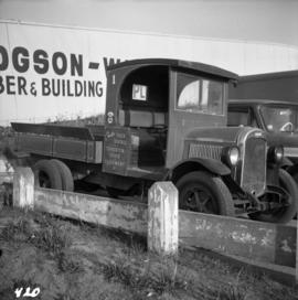
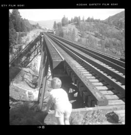
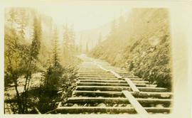
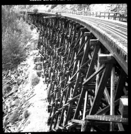
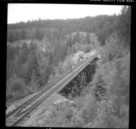
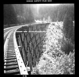
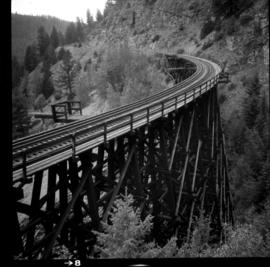
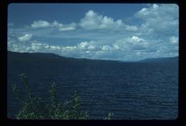
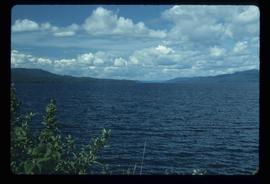
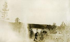
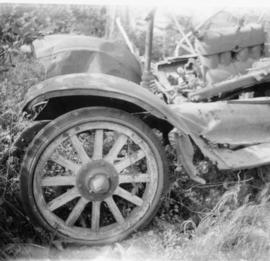
Photograph depicts an old truck that was found besides a logging yard and CNR trackage.
Photograph is part of a series of photographs depicting Olin Corporation's Fria location.
Photograph depicts a truck carrying asbestos on a winter road.
Photograph depicts a truck at the Teepoortens Truck and Equipment Rentals Ltd., located at 950 West 6th Ave. in Vancouver, BC
Photograph depicts a group of men standing to right of large truck, houses in in background. Boom of crane visible between truck and houses. Trees and power lines also visible.
Photograph depicts Trout Lake Johnny. The original photograph was from the collection of the uncle of G.S. Andrews.
Photograph depicts the one and only service station that was in Trout Lake City. It had manual pumps as there was no distributed electricity in the village.
Photograph depicts the Trout Creek CPR bridge near Summerland, about 9 miles north of Penticton. It is about 620 ft. long and the creek is 240 ft. below it. It was part of the Kettle Valley Railway.
Photograph depicts the Trout Creek CPR bridge near Summerland, about 9 miles north of Penticton. It is about 620 ft. long and the creek is 240 ft. below it. It was first crossed by the Chief Engineer's train on October 25, 1913. The view is looking south east.
Photograph depicts Trout Creek Bridge of the KVR.
Two individuals working on a boat engine in the water
Videotape contains footage of: 20-Aug-01 - County Mayor of Tromso, continued - Rindestu, Ronald / 21-Aug-01 - Medical program presentation in Tromso - Jago, Charles; Blouw, Max / 21-Aug-01 - Shots of Tromso, University, Tech Park
Image depicts numerous skiers at the cabin located at Troll Lake on Tabor Mountain in Prince George, B.C.
Item is a audio cassette recording labelled : "Tristrams Book". Readers: Bill Schermbrucker, Alban Goulden, Jon Furberg, Penny Connell, and Brian Fawcett. Taped: June 23, 1980. Broadcasted: CFRO June 30, 1980 at Classical Joint in Vancouver, B.C. Music by: Al Neil. Topics: Poetry and story recitals.
Photograph depicts a view of a lake, aspens in the foreground, low rolling hills in the background.
Photograph depicts five or more men standing near a tent frame. There are several packs on the ground and two horses loaded with packs. There is a bridge or dock on the right, a body of water and forested hills in the background.
Photograph depicts a man standing behind a loaded wagon, water and rolling, forested hills in the background.
Photograph depicts three cows on the edge of a lake, grass in the foreground, low rolling hills in the background.
Photograph depicts a view of the lake, aspens in the foreground, low forested hills in the background.
Photograph depicts a view of a lake from above, aspens in the foreground, low rolling hills in the background.
Image depicts a snow-covered cabin and a mountain in the distance. It is located somewhere near Birken, B.C.
Image depicts a mountain in the distance. It is located somewhere near Birken, B.C.
Image depicts a group of people preparing to depart on a trip. Location is uncertain, though it is possibly in Prince George, B.C.
Footage of a pack train along a river, a campsite, view of the mountains, and two grouse.
Location is believed to be the Rainbow Mountains.
Frontal detail of a trio of white petalled flower heads
Detail of <i>Rubus parviflorus</i> in flower
Northern British Columbia
ATV at campsite, Nunavut
Photograph depicts a wooden trestle constructed along a steep cliff through a wooded environment. Handwritten annotation on verso reads: "Trestle work through upper canyon 1/2 mile below intake, Germansen Placer Ltd."
Photograph depicts a wooden trestle designed for carrying water flumes. Annotation on verso of photograph states: "Trestle work for carrying water flume - Germansen Placer Ltd"
Photograph depicts a wood trestle constructed in a cleared forest area. Handwritten annotation on verso of photograph reads: "Trestle nearing completion across valley of south fork of Germansen Creek".
Photograph depicts a wooden trestle under construction along a hillside within a forested landscape. Handwritten annotation on verso of photograph reads: "Trestle work three (?) Upper Canyon 200 yards below intake, Germansen Placer Ltd."
Photograph depicts a trestle on the ex CPR Coquihalla line of the Kettle Valley Railway. It is a famous view spot because the trestle has a waterfall behind it. It is now the only intact trestle on the line because even the very small ones were demolished after the line closed on 23 November 1959. It is located about mile 21.7 from Brookmere. The grade here is about 1 in 53.
Photograph depicts a trestle of the Great Northern Railway, main line to Blaine, curving towards the southwest from the south end of the New Westminster rail bridge.
Photograph depicts the trestle leading to the Canadian National Railway (CN) swing bridge across the north arm of the Fraser River. The view was taken on Lulu Island, looking northeast. The ground on each side of the trestle is peaty and springy when walked on.
Photograph depicts a trestle on the south bank of the north arm of the Fraser River leading from the C.N.R. swing bridge, approximately 5 miles southeast of New Westminster, looking south.
Photograph depicts a trestle over railroad tracks in an unknown snowy location. (Possibly Mountain Park?)
Photograph depicts a trestle bridge on the old CPR Kettle Valley Railway. It is about 5 miles southeast of Brookmere, between Thalia and Spearing on the Princeton Subdivision.
Photograph depicts the CPR Kettle Valley Railway in Myra Canyon. This is one of the nine wooden trestles between mile 85 and mile 86.4
Photograph depicts the CPR Kettle Valley Railway in Myra Canyon. It shows the a wooden trestle fitted with a sidewalk, which at 434 ft. long is the longest one in the canyon. It is located at mile 85.9. The view is looking south.
Photograph depicts the CPR Kettle Valley Railway in Myra Canyon. The view is looking north at the trestle located at mile 85.4
Photograph depicts the CPR Kettle Valley Railway in Myra Canyon. It shows the a wooden trestle fitted with a sidewalk, which at 434 ft. long is the longest one in the canyon. It is located at mile 85.9. The view is looking south.
Photograph depicts the CPR Kettle Valley Railway in Myra Canyon. It shows the a wooden trestle fitted with a sidewalk, which at 434 ft. long is the longest one in the canyon. It is located at mile 85.9. The view is looking north.
Photograph depicts a trestle bridge for road traffic leading to the Second Narrows Bridge in Vancouver, BCThe shot is taken from the south bank.
Aerial view, Yellowknife, Northwest Territories
Sunset and darkness on Trembleur Lake, Northern British Columbia
Image depicts a west-looking view of Trembleur Lake.