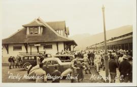
Photograph of a large crowd gathered at the McBride train station. Printed annotation on recto reads: "'Rocky Mountain Rangers Band, McBride, B.C.'"
Photograph depicts men on river scow, large rock island or peninsula protruding into river behind them. Trees on opposite shore in background, large rock in foreground. Handwritten annotation on verso of photograph: "Grand Canyon. Fraser River. Big Rock.", on recto of copy print: "1911."
Image depicts ridge-like rock formations at an uncertain location, though possibly somewhere near the Fraser River.
Carvings visible on a moss covered rocky outcrop. Handwritten annotation in pencil on verso reads: “Rock carvings. Copper Mountain, Al”.
Image depicts the peak of the Rocher de Boule mountain from Hazelton, B.C.
Photograph depicts Roche Myette along Davona Creek near a campsite.
Image depicts what is possibly the Robson River.
Image depicts a river, possibly the Robson River.
Image depicts what is possibly the Robson River.
Image depicts an old log cabin with the sign "Robin Hood Flour" on it at an uncertain location. It is possibly at the 153 Mile House.
Image depicts the road to Skagway, Alaska. Possibly located on the Klondike Highway in British Columbia with Tutshi Lake on the left.
Image depicts a road leading to Prince Rupert, B.C.
Image depicts the dirt road leading to Keithley Creek.
Image depicts the road leading to Hyder, which is on the other side of the Alaska-British Columbia border and is just a little south-west of Stewart, B.C.
Image depicts a road located somewhere near Birken, B.C.
Photograph depicts a road through a forest.
Image depicts a north view of a road somewhere in Woodpecker, B.C.
Image depicts a ditch near a road somewhere in Woodpecker B.C.
Image depicts a road somewhere in Woodpecker, B.C.
Image depicts a water-filled ditch near a road somewhere in Woodpecker B.C.
Image depicts a road somewhere in the Upper Fraser Canyon, and a view of the hills and trees.
Image depicts a mountain located somewhere along the Skeena River, and a road alongside it.
Image depicts a road with what appears to be a junkyard to the right of the image, likely located somewhere in Seton Portage, B.C.
Lofty view of stern wheeler in river, snow capped mountains in background. Printed annotation on recto reads: “R.M.S. B.C. Express in Upper Canyon Fraser River.”
Water and dock in foreground, trees and cliffs in background.
Handwritten annotation on verso “’Boat Hammond at South Fort Geroge”.
Photograph depicts tree-covered cliffs on opposite shore, river in foreground.
Image depicts a river with dense trees on either side.
Image depicts a river full of logs, somewhere near Bralorne, B.C.
Photograph depicts unidentified river flowing through hills, trees in foreground, mountains in background.
Photograph depicts river winding through range of hills, bridge visible in distance.
Photograph depicts unknown river winding through steep cliffs, trees on either side.
Image depicts a ferry on a river, possibly the Fraser River in the Lillooet area.
Trees and riverbank cross midground. Single tree in foreground, mountain in background.
Photograph depicts sternwheeler, smaller boat, and canoe in foreground. Second sternwheeler named the 'Caledonia' can be seen anchored to shore in background. Town buildings stand on hill in background. Photo believed to have been taken in Port Simpson, B.C.
Photograph depicts an unidentified river flowing through snowy area, trees on left, hill on right. Barbed wire fence crosses foreground.
Image depicts what appears to be a small, narrow river, and mounds of snow. The location is uncertain.
Image depicts a river, possibly either the Nechako or the Fraser, and a mountain range from an unknown location.
Image depicts a river on the left of the image and a range of mountains in the distance, located somewhere near Bralorne, B.C.
Photograph depicts wide river with forest shores on either side. Power lines in foreground, mountain in background.
Image depicts a man in a canoe on a river somewhere in South Tweedsmuir Provincial Park. The man is possibly Kent Sedgwick.
Image depicts a canoe on a river somewhere in South Tweedsmuir Provincial Park.
Image depicts what is possibly a section of the Tseax River.
Image depicts a river and a hillside at an unknown location.
Image depicts a river, possibly the Nechako, in Prince George, B.C. Possibly taken from the Foothills Bridge.
Image depicts a river at an uncertain location.