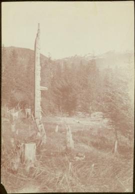
Child stands in distance beside tall totem pole. Tree stumps in foreground, forest and mountains in background.
Handwritten annotation on verso reads: "[Sanabati near Upper Queen?] Kasaan Alaska".
Child stands in distance beside tall totem pole. Tree stumps in foreground, forest and mountains in background.
Handwritten annotation on verso reads: "[Sanabati near Upper Queen?] Kasaan Alaska".
Image depicts the location of a slump type of landslide at Moose Heights, north of Quesnel, B.C.
Image depicts an aerial view of a section of land, likely near the Fraser River, that is possibly either a slump or part of a mining operation. The slide is labelled "slump or mining."
Image depicts what is likely a slump slide at an unknown location.
Image depicts an unknown individual standing near what is most likely a slump slide at an uncertain location.
Image depicts two unknown individuals standing near what is most likely a slump slide at an uncertain location.
Image depicts an unknown individual standing next to what appears to be a slump type of landslide at an unknown location.
Image depicts a slug on the forest floor somewhere on Haida Gwaii.
Image depicts a few unknown individuals canoeing in a slough area while on approach to Bowron Lake.
Image depicts a slough area while on approach to Bowron Lake.
Image depicts the slopes of Tabor Mountain in Prince George, B.C.
Image depicts numerous skiers cross-country skiing on a trail through trees on the Birchleg Ski route on Tabor Mountain in Prince George, B.C.
Image depicts numerous skiers on the Birchleg Ski route on Tabor Mountain in Prince George, B.C.
Image depicts numerous skiers and skis that are standing upright in in the snow on Tabor Mountain in Prince George, B.C.
Image depicts a vehicle and a large group of skiers somewhere on Tabor Mountain in Prince George, B.C.
Image depicts a skier in a costume with a fake sword, somewhere on the Birchleg Ski route on Tabor Mountain in Prince George, B.C.
Photograph depicts a dock and building near the water. A few buildings are being constructed on some newly cleared land nearby.
Image depicts the community of Skidegate on Haida Gwaii.
Photograph depicts crowd of people in foreground near log fence. More crowds can be seen in distance at base of ski jump on either sides of the run. Jump visible at top of tree-covered hill in background. It is believed that this photograph was taken near the current location of City Hall.
Image depicts the Skeena River somewhere near Prince Rupert, B.C.
Image depicts the Skeena River, as well as a stretch of highway that appears to be under construction.
Image depicts the Skeena River at Hazelton, B.C.
Image depicts the Skeena River.
Forest and mountain visible in background.
Image depicts two totem poles in Skeena Crossing, B.C.
Image depicts Skeena Crossing, B.C.
Image depicts the Skeena River at Hazelton, B.C.
Image depicts the bus depot in Skagway, Alaska (USA).
Image depicts one of the main streets, Broadway, in Skagway, Alaska.
People, boardwalks, and store signs visible in street scene. Printed annotation on recto reads: “6th St. Prince Rupert. B.C.” Handwritten message in ink on verso is addressed to: “Mrs. Loistram Halls Buildings Nicholas St Limerick Ireland”. Verso stamped "PRINCE RUPERT JUN 30 10".
Photograph depicts Siwash Rock in Stanley Park British Columbia.
Image depicts railway tracks and buildings with a beehive burner on the left. The location is likely Sinclair Mills, B.C. Map coordinates 54°01'17.4"N 121°40'53.0"W
Image depicts a beehive burner covered in snow in Sinclair Mills, B.C. Map coordinates 54°01'17.4"N 121°40'53.0"W
Image depicts layers of silt along the Chilako River near Blackwater Road, Prince George, B.C.
Photograph depicts sign in foreground outlining rules and restrictions for behaviour at Moricetown Canyon. Traditional fishing territory visible behind sign at waterfall in the Bulkley River, B.C. Highway and buildings can be seen in background.
Side view photograph of a small harbor close by a shoreline littered in organic debris. A foggy mountain range is visible in the background. Annotation on recto reads: "Wharf and Harbor Prince Rupert. May 1908 JDA."