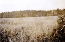
Typed caption glued to album page directly below photograph reads: "14. Oats at Fort Fraser." Photograph depicts a field of oats edged by a wooden fence. Photographer: Dominion Stock & Bond Corporation.
Sally Tretiak standing outside with hands clasped. An automobile and a building visible in the background. Handwritten annotation on verso reads: "1932, Sally Tretiak, Indian nurse, Kispiox".
Photograph depicts numerous buildings along a shoreline with water in the foreground.
Photograph depicts forklift operator Novica Dancetovic in shipping.
Photograph depicts a notice posted in Stanley Park at the head of Coal Harbour, Vancouver, B.C. Notice is for summer visitors only.
Photograph depicts the notice on the outer door of the Great Northern Railway depot in Vancouver.
Photograph depicts a notice found on old North Vancouver Ferry #3, moored as a tender at Western Fish Boat Works, Queensborough, Lulu Island. It was signed by the Corporation of North Vancouver.
Item consists of a summary document entitled "Notable Surveys" by Mrs. W.K. Rutherford, V.C. Brink, R.S. Silver, and M.Z. ("Smokey") Neighbour. The document summarizes Knox McCusker's notable surveys. This article may have been put together by the authors for, or in conjunction with, a submission to a historical serial publication.
Image depicts the office at the Northwood Upper Fraser Saw Mill and a sign which reads "Have a safe, quality day." Map coordinates 54.117916, -121.943351
Image depicts the Northwood pulpmill in Prince George B.C.
Image depicts the Northwood Pulpmill in Prince George, B.C. taken from above the Nechako River looking east. Map coordinates 53°56'00.0"N 122°44'29.7"W
Image depicts the Northwood pulpmill in Prince George B.C.
Photograph depicts Northwood Pulp and Timber Ltd, Prince George. Located north of the city, near the BC Rail and CNR mainline tracks. It had its own railway of about 5 miles in length and two diesel switchers.
Large-format map depicts Northwood Pulp & Timber operating areas in 1975.
Overview of washer line.
View of new control room post mill expansion. Seated with back turned is Nells Kristenson (group operator).
The new digester building under construction.
P.G.E. railcar filled with chips being dumped via hydraulic chip dump.
Brown stock decker.
Aerial perspective - Pulp mill complex, pre-expansion - dramatic night shot.
Image depicts the Northwood Bridge crossing in Prince George B.C.
Image depicts the Northwood Bridge in Prince George, B.C.
Image depicts what appears to be a saw mill belonging to Northwood. The location is uncertain.
Photograph depicts a Northwestern Pacific speeder.
Photograph depicts the view to the northwest from the site of the terminal building at the Rainbow Lake Ski Club.
Photograph depicts a small coastal village in northern British Columbia.
Photograph depicts a northward view of the east side of the CN yards at the Kamloops Junction.
Photograph depicts a Northland steam tug at Vancouver. The tug, "Commodore Straits," one of the largest on the coast of B.C.
Image depicts an old building with a sign labelled "Northern Rooms" in an uncertain location somewhere in Prince George, B.C.
Item is an original "Northern Interior Forest Experiment Station: Report of Preliminary Investigations" by Percy Barr. Includes original photographic prints.
Item is a poorly photocopied version of Percy Barr's "Northern Interior Forest Experiment Station Progress Report". Location of original is unknown.
Photograph depicts a landscape scene in northern British Columbia in an unknown location.
Regional map depicting communities, parks, customs posts, airports, radio stations, hatcheries, bodies of water, transport routes, communication lines, elevation points, and lines of batholith contacts. Includes an inset of St. Elias Mountains. Includes “Special Note on the Mineralization of this Map Area” from Bureau of Mines, Victoria, B.C.
Regional map depicting land recording divisions, communities, bodies of water, transport routes, elevation, and lighthouses.
This document is an unpublished draft manuscript of a Northern British Columbia history annotated bibliography. The document is based overwhelmingly on research into secondary sources published prior to 2016; more recent sources are not included. The annotated bibliography includes the following sections:
- Historiography
- Settlement Histories
- Alexander Begg's History of British Columbia
- R.E. Gosnell
- E.O.S. Scholefield
- Regional History
- New Histories
- Environment
- Northern History
- Ancient History
- Bibliography
Photograph depicts northbound freight passing near the Salmon Arm depot.
Photograph depicts tramline in a strip cleared of trees on McDame Mountain, bucket in foreground. Handwritten annotation on recto of photograph: "#2 SECTION LOOKING NORTH". Photograph was glued to cardboard backing with the annotation: "1962".
Photograph depicts tramline in a strip cleared of trees on McDame Mountain, bucket in foreground. Handwritten annotation on recto of photograph: "1961 - 62".
Photograph depicts the North Vancouver Ferry #3 at Western Boat Works in Queensborough. It is used as a tender and workshop.
Photograph depicts North Vancouver Ferry #3 at Western Boat Works in Queensborough on Lulu Island.
Photograph depicts the North Vancouver Ferry #3 at Western Boat Works at the extreme east end of the Westminster Highway on Lulu Island. It appears to be watertight.