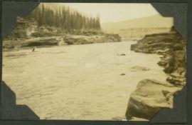
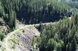
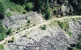
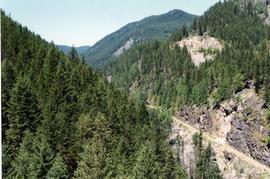
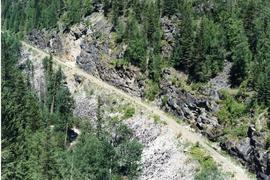
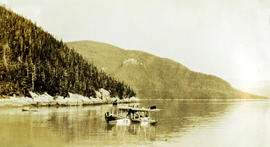
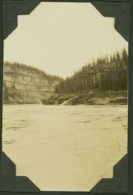
Caption: "Entrance to the Rocky Mountain Canyon, Peace River. 19 miles of Canyon."
Photograph depicts the Peace River Canyon with the Peace River in the foreground and rocky, tree-lined cliffs flanking the river. In the background a forested mountain base is visible.
Photograph depicts the Peace River curving around the tree-covered cliffs at the Peace River Canyon.
Item is a photograph of a boat on the Peace River. The name of the boat reads as follows: "Fort Vermilion".
Photograph depicts the Peace River leading up to a strait called the "Gate" at Lynx Creek. The narrow strait is flanked by a forested, rocky shoreline.
Image depicts the W.A.C. Bennett Dam on the Peace River in Hudson's Hope, B.C.
Image depicts a large group of unidentified individuals sitting on a hill; what is possibly the Peace River is visible in the background.
Image depicts what is possibly the Peace River running next to some farm land at an uncertain location.
Image depicts a dam and a reservoir of water, possibly on the Peace River.
Image depicts a dam, possibly on the Peace River.
Image depicts a dam on what is possibly the Peace River.
Colour-coded topographic map depicting surveyed lands alienated, available for purchase or lease, or available for pre-emption. Depicts land districts, land recording districts, parks, communities, bodies of water, transport routes, communication lines, and triangulation stations.
Image depicts the Peace River, possibly near Clayhurst or Hudson's Hope, B.C.
Image depicts what is possibly the Peace River.
Image depicts a river, possibly the Peace River.
Image depicts what is possibly the Peace River running parallel to a road, possibly Highway 29.
Image depicts the Peace River.
Image depicts the Peace River and visible layers of sediment deposits in the surrounding cliffs.
Image depicts the Peace River, possibly somewhere near Fort St. John, B.C.
Image depicts the Peace River, possibly near Hudson's Hope, B.C.
Image depicts the Peace Canyon Dam and generating station under construction on the Peace River.
Side perspective photograph of a Portland Canal Short Line engine being either loaded or unloaded by several men at the station in Stewart, BC. Printed annotation on recto reads: "Aug 9 1911 Stewart BC."
Side perspective photograph of a crowd of people gathered around a Portland Canal Short Line Railroad train, presumably either leaving or arriving Printed annotation on recto reads: "Bitter Creek BC Aug 9 1911."
Image depicts the road to Pavilion Mountain.
Image depicts the remains of an old bridge, somewhere near Pavilion Mountain.
Image depicts an old earth flow somewhere near Pavilion, B.C.
Image depicts the First Nations village of Pavilion, B.C.
Photograph taken at the Paulson Highway Bridge.
Photograph taken at the Paulson Highway Bridge. Site of a snow shed until the early 1980's when it was demolished and a slide fence was installed.
Photograph taken at the Paulson Highway Bridge.
Photograph taken at the Paulson Highway Bridge. KVR track visible on a former Boundary Subdivision between Castlgar and Grand Forks.
Image depicts an old theatre owned by Paul Aivazoff in Prince Rupert, B.C. It opened in 1935 and was closed in 1981; it has since been renovated for retail use.
Photograph depicts the rail connections below the north bank of the Patullo Bridge in New Westminster. The track in the foreground belongs to C.N. and the flyover foreground rail bridge belongs to the B.C. Electric Railway. The flyover background rail bridge is shared by the Great Northern Rail and C.N. Rail.
Photograph depicts the Patullo Bridge in New Westminster, looking east with the rail bridge in the background.
Image depicts a view of a valley; the slide itself labels the image in two places, "central basin" on the left side of the image, and "Pat's Pass" on the top of the image between the two mountains.
Photograph depicts an unknown man in the Queen Charlotte City library listening to a recording and taking notes
Photograph depicts a plane on water. Handwritten annotation below photograph reads, "Patrol plane E.B.".
Photograph depicts the past Exhaulted ruler of the Kitimat Elks presenting Iona Campagnolo with handmade rafting figurines at the Kitimat Delta King Days raft event. Mayor George Thom and two unidentified men watch the presentation.
Photograph depicts the past Exhaulted ruler of the Kitimat Elks presenting Iona Campagnolo with handmade rafting figurines at the Kitimat Delta King Days raft event. Campagnolo speaks into a microphone. An unidentified man stands behind Campagnolo watching the presentation.
Photograph depicts the past Exhaulted ruler of the Kitimat Elks presenting Iona Campagnolo with handmade rafting figurines at the Kitimat Delta King Days raft event. An unidentified man stands behind Campagnolo watching the presentation.
Photograph depicts a passing spur on the B.C. Electric Railway at Kennedy Station, 4 miles south of New Westminster. The view is looking north.