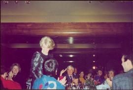
Giles stands between banquet tables, John can be seen clapping in centre background.
Handwritten notations affixed to verso read: “Giles Turner (blackdress)” and “John Turner[Liberal Party Leader]”.
Giles stands between banquet tables, John can be seen clapping in centre background.
Handwritten notations affixed to verso read: “Giles Turner (blackdress)” and “John Turner[Liberal Party Leader]”.
Photograph depicts a field and fence in the foreground, an orchard in the midground, a rocky mountain slope in the distance.
Photograph depicts a rocky, mountain slope.
Photograph depicts a field and fence in the foreground, an orchard in the midground, a rocky mountain slope in the distance.
Photograph depicts a large elaborate church building. Handwritten annotation below photograph reads, "Gospel Mill at Kincoolith - Naas River".
Image depicts the Ginter House in Prince George, B.C.
Image depicts the Ginter House and the surrounding woods, in Prince George, B.C.
Image depicts the Ginter House in Prince George, B.C.
Image depicts what appears to be a part of a fence on the Ginter Property in Prince George, B.C.
Image depicts a swimming pool filled with debris in the interior of the Ginter House in Prince George, B.C.
Image depicts the interior of the Ginter House in Prince George, B.C.
Image depicts a private driveway, most likely leading to the Ginter Property in Prince George, B.C.
Image depicts a road near the Ginter House in Prince George, B.C.
Image depicts the Ginter Property in Prince George, B.C.
Photograph depicts an existing girder bridge, in use since 1962. A new concrete bridge was being built on the left.
Photograph depicts an old girder bridge.
Photograph depicts a covered wooden grider bridge of the former Great Northern Railway spur that ran from north Washington state into B.C. at Keremeos, then west to Princeton. It was now only operating as far north as Keremeos.
Photograph depicts a covered grider bridge of a former railway (subsidiary of the Great Northern Railway, built in 1907-14) that formerly ran between Keremeos and Princeton, but had long since been lifted. The bridge was now used by vehicles going to a nearby ranch.
Young girl stands with dog in front of an adult on flatbed pulled by horse in foreground. Fence, building, trees, and hills in background. Handwritten annotation on recto of photograph: "[Gineva?] - and Eleanor (my niece)."
Item is a photograph of the girls basketball team in Salmon Arm. Ray Williston is on the left.
Photograph depicts girls dancing at the opening of the Haisla Recreation Centre in Kitamaat Village.
Photograph depicts a girls' school, Strathcona Lodge, at Shawnigan Lake.
Image depicts the Giscome, B.C. town site with the Giscome railway station and the Giscome store in the center surrounded by vehicles. Map coordinates 54°04'18.5"N 122°21'57.7"W
Image depicts a Catholic church in Giscome, B.C. Map coordinates 54°04'15.5"N 122°21'52.1"W
Image depicts a church in Giscome, B.C. Map coordinates 54°04'16.2"N 122°21'54.3"W
Image depicts the CN Station, with bundles of wood sitting near the tracks, in Giscome, B.C. Map coordinates 54°04'32.3"N 122°21'42.3"W
Image depicts mill site and dock in Giscome, B.C. with Eaglet Lake in the background covered in ice. There is a large crowd of people gathered near the dock. Map coordinates 54°04'34.9"N 122°21'50.0"W
Image depicts the remains of a street of houses in Giscome, B.C. The quarry is slightly visible in the background. Map coordinates 54°04'20.9"N 122°21'53.1"W
Image depicts a street of houses in Giscome, B.C. Map coordinates 54°04'20.9"N 122°21'53.1"W
Image depicts the Giscome mill site in Giscome, B.C. The railroad tracks are in the foreground. Map coordinates 54°04'17.6"N 122°22'06.1"W
Image depicts the Giscome mill site in Giscome, B.C. The bunkhouse is the large building with many windows. A train and railroad tracks are in the foreground. Map coordinates 54°04'17.6"N 122°22'06.1"W
Image depicts the Giscome bunkhouse in Giscome, B.C. Map coordinates 54°04'17.6"N 122°22'06.1"W
Image depicts the old CN station in Giscome, B.C. Map coordinates 54°04'20.7"N 122°22'01.1"W
Image depicts the new CN station in Giscome, B.C. Map coordinates 54°04'20.7"N 122°22'01.1"W