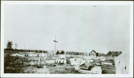
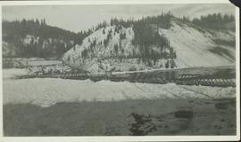
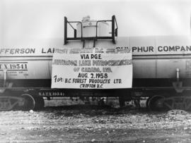
Photograph depicts the first shipment of sulphur via Pacific Great Eastern Railway August 2nd, 1958. Part of a set of 13 black & white photographs of British Colombia Railway & it's precursor, Pacific Great Eastern Railway (1912 - 2004) in British Columbia. Photos depict locomotives, railroad cars, and crew members. «
Photograph depicts rows of grave markers in foreground, fence and buildings in background.
Handwritten annotation on verso “Indian cemetery, Reserve #1 South Fort George".
Photograph depicts several people in a large field. There are buildings and trees in the background.
Image depicts a snow sculpted fire place and couch on a skating rink, possibly during the Winter City Conference, in Prince George, B.C. Taken at the Prince George Civic Center. Map coordinates 53°54'45.6"N 122°44'59.6"W
Image depicts numerous tractors at Finning Tractor and Equipment Co. Ltd. located along Highway 97 in Prince George, B.C.
Image depicts numerous skiers standing near a finish line somewhere on Tabor Mountain in Prince George, B.C.
Image depicts the intersection of 5th Ave and Highway 97 looking northeast. Map coordinates 53°55'14.0"N 122°46'54.8"W
Image depicts a farmhouse on Old Summit Road in Prince George, B.C.
Photograph depicts men, women, and infant seated in the Canfor Theatre at the University of Northern British Columbia in Prince George, B.C. Unidentified individuals sit in seats in background. Accompanying note from Maureen Faulkner: "Next row down is R. [Roseanne Moran] & the Kennedy's, I move to join her next to walkway." Photo taken on the day Bridget Moran received an Honourary Law Degree.
Photograph depicts men, women, and infant sitting in crowded Canfor Theatre at the University of Northern British Columbia in Prince George, B.C. Accompanying note from Maureen Faulkner: "Your family. now behind R [Roseanne Moran] + me. look on with pride & interest." Photo taken on the day Bridget Moran received an Honourary Law Degree.
Image depicts some fallen trees at Island Cache.
Image depicts a view of an experimental farm, possibly taken from Tabor Mountain.
Image depicts the Exhibition Sports Centre, which used to be a drill hall army base, on Keller Street in Prince George, B.C.
Image depicts the Europe Hotel in Prince George prior to its demolition in the 1980s; however, the slide itself was only made in 1999 and the date of the photo is otherwise unknown, but most likely around 1979.
Image depicts Eskers Park, near Prince George, B.C.
Photograph taken on a 40 ft. high embankment. Looking towards Fraser River. Northwood Pulp and Timber Ltd. in western direction. All trackage owned and built by the mill. Constructed in 1966.
Row of buildings with path and poles. Rough cleared land in foreground, men visible in far left background.
Early spring landscape with roadbed and track in foreground, river in midground, and hill in background.
Handwritten annotation on recto: “PRINCE GEORGE 4-20-13”.
Photograph depicts a tarp spread out on the grass, two men sit nearby the tarp. There is a canvas tent in the background with a man standing beside it. Behind the tent is a low hill with a fence bordering the top of the hill. There are blankets drying on the fence.
Image depicts George St in downtown Prince George with City Hall in the background. Also visible are the Prince George Hotel and a movie theatre. Map coordinates 53°54'55.0"N 122°44'36.1"W
Image depicts George St in downtown Prince George with City Hall in the background. Also visible are the Prince George Hotel, Ming's Inn Chinese Restaurant, Fraser Stationers Ltd., Weiner King food cart, and a movie theatre. Map coordinates 53°54'55.0"N 122°44'36.1"W
Image depicts 4th Ave at Brunswick St. and the following businesses: Hart Drugs, The Yarn Barn, and Saveco. Map coordinates 53°54'59.9"N 122°44'52.9"W
Image depicts 4th Ave at Quebec St, showing the following businesses: The Yarn Barn, Golden Chalice Jewellers, Dandy Lines, Ultrasport, and Saveco. Map coordinates 53°54'58.6"N 122°44'47.5"W
Image depicts downtown Prince George taken from City Hall looking north. Map coordinates 53°54'46.2"N 122°44'43.9"W
Image depicts a view of Prince George from City Hall looking northeast with the pulp mills in the background. Map coordinates 53°54'46.3"N 122°44'41.9"W
Image depicts downtown Prince George taken from City Hall looking north. Map coordinates 53°54'46.2"N 122°44'43.9"W
Image depicts downtown Prince George taken from City Hall looking northwest. Map coordinates 53°54'46.2"N 122°44'43.9"W
Image depicts downtown Prince George, B.C.
Image depicts an aerial view of downtown Prince George, B.C.
Image depicts two dogs and numerous chickens in a yard at Island Cache.
Image depicts the demolition of the Europe Hotel in Prince George, B.C.
Image depicts the rubble of a demolished house at Island Cache, with several other buildings in the background.
Image depicts a house in the process of being demolished in Prince George, B.C.
Image depicts a sawmill in the Danson Industrial Park in Prince George, B.C.
Image depicts a the Danson Industrial Park in Prince George, B.C.
Image depicts an area of cut trees at Island Cache.
Image depicts a backyard filled with various items piled against a shed in Island Cache.
Image depicts a large crowd of people on a section of the Heritage Trail on Cottonwood Island in Prince George, B.C.
Image depicts a crowd of people on a section of the Heritage Trail on Cottonwood Island in Prince George, B.C.
Photograph depicts a photographer and other men standing over a crowd at Northern BC Winter Games event in Prince George.