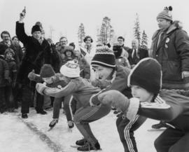
Photograph depicts Pierre Trudeau firing a starting pistol at a children's speed skating event during the 1978 Northern BC Winter Games. Iona Campagnolo, Ron Bassford and an unidentified crowd watch four children crouch at the starting line.
Photo taken in the late spring of 1936 at the west end of the CNR bridge when flood waters had covered up what was then known as the "tourist camp".
Image depicts Pine Centre Mall in Prince George, B. C. Map coordinates 53°53'53.2"N 122°46'36.4"W
Image depicts an aerial view of Pine Centre Mall and Masich Place Stadium in Prince George, B.C.
Image depicts Pineview on Buckhorn Lake Road, Prince George, B.C.
Image depicts an old barn somewhere in the Pineview subdivision in Prince George, B.C.
Image depicts an old Swedish style house somewhere in the Pineview subdivision in Prince George, B.C.
Photograph depicts a plough found near Clulculz Lake, 45 miles west of Prince George. Its metal parts were made in the USA.
Image depicts a powerhouse in Prince George, B.C.
Image depicts power lines east of the pulp mills in Prince George, B.C.
Photograph depicts Prime Minister Pierre Trudeau and three women in a crowd at a Northern BC Winter Games event in Prince George.
Photograph depicts Prime Minister Pierre Trudeau, Evelyn Basso, and a man standing in a crowd at a Northern BC Winter Games event in Prince George.
Image depicts a view of Prince George from City Hall looking northeast along George Street. Map coordinates 53°54'46.3"N 122°44'41.9"W
Image depicts downtown Prince George looking northwest. Map coordinates 53°54'48.7"N 122°44'45.6"W
Image depicts a view of Prince George from City Hall looking northeast along George Street. Map coordinates 53°54'46.3"N 122°44'41.9"W
Image depicts Prince George, possibly with the Northwood Pulpmill in the background.
Image depicts a view of Prince George from an uncertain location.
Image depicts a view of Prince George.
Image depicts Prince George, B.C.
Image depicts an aerial view of what is possibly an outlying area of Prince George, B.C.
Image depicts a view of Prince George.
Image depicts downtown Prince George looking northwest across Dominion Street. Map coordinates 53°54'48.7"N 122°44'45.6"W
Image depicts Prince George, possibly with the Northwood Pulpmill in the background.
Image depicts Prince George with numerous trees obscuring most of the view.
Image depicts Prince George.
Image depicts a view of Prince George.
Image depicts Prince George from University Way, with the P.G.I pulp mill in the distance.
Image depicts Prince George from University Way, with the P.G.I. Pulp Mill in the distance.
Image depicts Prince George, with the picture looking North-Northeast from University Way.
Image depicts a sawmill in Prince George, B.C.
Image depicts an uncertain street in Prince George, B.C.
Image depicts Brunswick Street at 3rd Ave in -35 degree weather. Map coordinates 53°55'03.0"N 122°44'51.7"W
Image depicts 3rd Ave at Brunswick Street in -35 degree weather. Map coordinates 53°55'03.0"N 122°44'51.7"W
Image depicts Prince George at night from the cutbanks.
This very large drawing shows CN leases and private property buildings on Island Cache in detail.
Lockwood Survey Corporation Ltd.Image depicts a clearing in Prince George, B.C., possibly in the Pineview area.