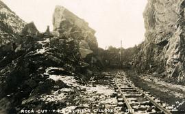
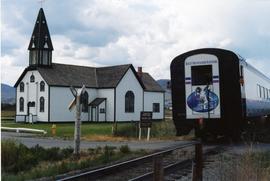
Photograph depicts a Rocky Mountaineer train with a propelling locomotive short distance away approaching Chilcoltin Road, Kamloops Indian Reserve.
Photograph depicts a Rocky Mountain vista seen through a snow-covered forest.
Photograph depicts a Rocky Mountain vista seen across a forested plateau.
Image depicts a view of the Rocky Mountain Trench somewhere near McBride, B.C.
Image depicts the Rocky Mountain Trench from McBride, B.C.
Image depicts a view of an area somewhere near McBride in the Rocky Mountain Trench.
Image depicts the Rocky Mountain Trench from McBride, B.C.
Image depicts a view of the Rocky Mountain Trench somewhere near McBride, B.C.
Image depicts a view of McBride in the Rocky Mountain Trench.
Image depicts a heavily forested area located in the Rocky Mountain Trench, possibly near Dome Creek or Lamming Mills, B.C.
Image depicts a view of the Rocky Mountain Trench.
Photograph of a large crowd gathered at the McBride train station. Printed annotation on recto reads: "'Rocky Mountain Rangers Band, McBride, B.C.'"
Photograph depicts the Rocky Mountain range visible from above distant tree tops.
Photograph is a printed postcard depicting a rock slide and creek near Stewart B.C.
Photograph depicts a low rock in deep waters, Handwritten annotation below photograph reads, "Rock in Mill Bank Sound, BC coast".
Photograph depicts men on river scow, large rock island or peninsula protruding into river behind them. Trees on opposite shore in background, large rock in foreground. Handwritten annotation on verso of photograph: "Grand Canyon. Fraser River. Big Rock.", on recto of copy print: "1911."
Photograph depicts the rock formations along the Cariboo Road north of Cache Creek. Wyness notes that the rock may be sandstone; there may be red iron oxide visible in the formation.
Image depicts ridge-like rock formations at an uncertain location, though possibly somewhere near the Fraser River.
Photograph depicts a snow-covered rock formation on the north side of Sentinl Peak
Photograph depicts the making of a rock cut on the Pacific Great Eastern Railway line at the Lillooet end of Seton Lake during railway construction.
Carvings visible on a moss covered rocky outcrop. Handwritten annotation in pencil on verso reads: “Rock carvings. Copper Mountain, Al”.
Image depicts the peak of the Rocher de Boule mountain from Hazelton, B.C.
Photograph depicts Roche Myette along Davona Creek near a campsite.
Image depicts what is possibly the Robson River.
Image depicts a river, possibly the Robson River.
Image depicts what is possibly the Robson River.
Photograph depicts a bird perched on a nest build on the side of a building. Handwritten annotation below photograph reads, "Robins nest June 1928-N.H."
Image depicts an old log cabin with the sign "Robin Hood Flour" on it at an uncertain location. It is possibly at the 153 Mile House.
Photograph depicts a dirt road 6 miles from the Alaska Highway.
Photograph depicts a dirt roadway in wooded area. Snow capped mountains in background.
Photograph depicts a truck on a newly cleared dirt road in a mountain pass and a wooded area.
Photograph depicts road vehicles parked outside of the CPR depot in Salmon Arm.
Photograph depicts a road trestle bridge for cars about halfway between south Wellington and Nanaimo Lake, southwest of Nanaimo.
Image depicts the road to Skagway, Alaska. Possibly located on the Klondike Highway in British Columbia with Tutshi Lake on the left.