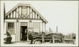
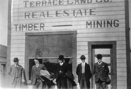
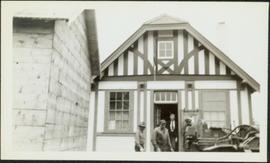
Photograph depicts four men in front of BC Government Liquor Store. Bulldozer and unidentified building in foreground. See also items 2009.5.2.76 & 2009.5.2.77.
Photograph depicts three men in front of BC Government Liquor Store, one standing in doorway. Bulldozer in foreground, fence and trees in background. See also items 2009.5.2.75 & 2009.5.2.77.
Photograph depicts two men standing beside beds of fish laid out to dry. More oolichan fish hang on tall structures in background.
Handwritten annotation on verso reads: "Oolichan drying & [?] grease at Fishing Bay Nass River 'Winter food supply'".
Photograph depicts men walking and standing on pier over water in unidentified area. A large pile of bundles can be seen on pier. Large buildings stand on shore, and trees cover hillside in background. Portion of a boat or ship tethered to shore is partially visible in right foreground.
Photograph depicts a large group of men standing on what appears to be a wood pier. Forest on shore in background.
Photograph depicts a copy of a June 1915 photograph that shows five men in front of the Terrace Land Company building. From left to right, these people include: J.K. Gordan of Terrace, John Oliver (future BC Premier), H.C. Brewster (future BC Premier), L.H. Kenney of Terrace, and T.D. Pattullo.
Photograph depicts nine men standing on small dirt lane between rows of tent buildings at what is believed to have been a railway construction camp. Snow and firewood piles line the road, forest trees in background.
Four men stand around small car and one man rides in wagon, driving team of horses. Seven buildings can be see in background among trees.
Photograph depicts two men standing on large wood framework structure. Rocky ground in foreground, trees visible in background.
Photograph depicts a crowd of men standing under balcony of three story hotel. Handwritten annotation on verso of photograph: "South Fort George, B.C."
Photograph depicts a brick Methodist church on a street beside houses. Annotation on recto of photograph states: "METHODIST CHURCH, ENDERBY, B.C."
Photograph depicts the exterior of a church with a steeple surrounded by trees. Annotation on recto of photograph states: "Methodist Church Port Simpson BC"
Photograph depicts a multi-level hospital surrounded by smaller buildings and a wooden walkway. Annotation on recto of photograph states: "Methodist Hospital, Bella Bella B.C. George E. Darby, B.A., M.B., Superintendent"
Image depicts buildings in the village community of Metlakatla, B.C.
Image depicts Metlakatla, located near Prince Rupert, B.C.
Image depicts buildings in the village community of Metlakatla, B.C.
Photograph depicts large buildings on shore. Three unidentified individuals can be seen walking on dock in foreground.
Printed on image: "METLAKATLA B.C. / McRAE BROS"; handwritten annotation on verso reads: "A section of Metlakahtla, showing Church & Schoolhouse." See also item 2009.7.1.58 for similar image also featuring the new church building at Metlakatla, B.C.
Image depicts several individuals looking down into a closed off section of a river in Meziadin Lake Provincial Park. They are counting fish.
Image depicts the fish ladder of the Meziadin Falls, designed to help fish swim upstream.
Photograph depicts the Midway CPR depot located at the eastern terminus of Kettle Valley Railway. It was a subdivisional point with way freights originating at Nelson and Penticton, and running west and east respectively to Midway. There are two to 3 freights weekly from Nelson and 1 to 2 from Penticton. It lost its agency in June 1969 and all small freight [
Image depicts a river in the Miles Canyon near Whitehorse Y.T. The Robert Lowe Bridge, built in 1922, can be seen over the canyon.
Image depicts the Robert Lowe Bridge, built in 1922, in the Miles Canyon near Whitehorse Y.T.
Handwritten photo album caption below this photo reads: "Barracks at Ft. S. John." Photograph depicts two long buildings with many tall windows on the side. The buildings are in a muddy area, and wood slat sidewalk runs in front of them. There is a large gravel pile between the buildings, enclosed with a short log fence. A man can be seen in front of second barrack in background.
Royal Canadian Air ForceHandwritten photo album caption below this photo reads: "Barracks at Watson Lake". Photograph depicts long building built in U shape. Wood piles and miscellaneous items can be seen in foreground.
Royal Canadian Air ForceParade of uniformed marchers with sign that reads: “Every little helps, Do your share” (with a large cross). Buildings on street in background. Printed annotation on recto reads: “Prince Rupert B.C.” Handwritten annotation in pencil on verso reads: “Prince Rupert B.C.”
Photograph depicts a mill and beehive burner.
Man driving a two horse cart in front of beehive burner, cart is full of bark presumably sawed off the logs.
Handwritten annotation in pencil on verso: "Mill Burner".
Photograph depicts the Mill of Kintail in Ontario after renovations circa 1976 when it became the R. Tait McKenzie Memorial Museum and conservation site, located near Almonte, Ontario.
Photograph depicts the Mill of Kintail near Almonte, Ontario prior to 1930.
Item is a photograph of a small mill operation.
Overview of the Giscome sawmill behind road. Lumber yard is visible in foreground while mill stands in background.
Handwritten annotation in pencil on verso: "Giscome Mill / lumber yard in foreground".
Image depicts a view of the Millar Addition suburb in Prince George, B.C.
Photograph depicts the Cassiar mine. North and South peak featured in background, and West peak in left foreground. Pit is being developed between South peak and West peak. Old mine garage is visible in lower centre of image, and crushing plant in right foreground. Mountain range in distance.
Photograph depicts a mine building at the copper mine in Britannia Beach. The mine was still in use and well maintained.
Photograph depicts the mine buildings of the mine at Coal Creek that closed in 1959. The newer buildings date to circa 1930. Much of the standard gauge trackage of Morrissey, Fernie, and Michel railway (subsidiary of the Great Northern Railway) in mine area remains. The track between Coal Creek and Fernie has not been lifted.
Photograph depicts a mine 200 yards south of Moyie village, which is 20 miles south of Cranbrook. It produced silver, zinc, and lead from 1900-1910 and had a smelter a quarter mile away. The shaft was 900 ft. deep, with levels going under Moyie Lake. The head gear dates from 1925-1935 and has electric winding.
Photograph depicts view of mine road in valley, from mountain above. Plant, tailings pile, and town visible in distance. South mountains in background. Handwritten annotation on verso of photograph: "1961", on recto: Townsite and Plantsite from mine."
Photograph depicts lumber piles and what appears to be a very long sluicing trough along Otter Creek. Forest and hills in background. Handwritten annotation on verso of photograph: "Otter Creek 6/6/37". See also item 2009.5.2.70.
Photograph is a printed postcard depicting an unidentified mining building situated on a hillside surrounded by mining debris. Possibly located in Stewart B.C.
Handwritten annotations on verso read: “East Berlin GDR, Spt. Minister,” and “16394/2”. Photograph taken during European Sports Tour with Team Canada.
Handwritten annotation on verso reads: “Cuba with Chuck Pilfold, ‘77”.
Photograph believed to have been taken during a Ministry of Sport Tour in Cuba, 1977 - 1978. See also items 2009.6.1.198 - 2009.6.1.224.
Photograph depicts the Mission City CPR depot located at mile 87.3 from North Bend in Cascade Substation. It was built in 1902 and add onto in 1909. It has living quarters on the 2nd floor that are still in use, which is quite rare for BC in 1973.
Photograph depicts the Mission City CPR depot located at mile 87.3 from North Bend in Cascade Substation. It was built in 1902 and add onto in 1909. It has living quarters on the 2nd floor that are still in use, which is quite rare for BC in 1973. It is 41.7 miles from Vancouver and 2, 839.6 miles from Montreal.
Photograph depicts the Mission City rail and road bridge. It is owned by the CPR and was opened in 1891. It was used by road vehicles between 1 July 1927 and the 23 June 1973, using a one way flow system. On the latter day, a new high level road bridge was unofficially opened. By early July 1973, the CPR had removed the wooden deck planking.
Photograph depicts a large two-storey building with the sign: "CALEDONIA HOSPITAL". Fence crosses foreground, hills visible in background.
Handwritten annotation on verso reads: "Mission Hosp at Metlakatla B.C."
Photograph depicts tall building, with long shorter section crossing midground in front. Path runs through garden in foreground.
Handwritten annotation on verso reads: "Back of Mission House Kincolith".
Photographs depict large building in fenced area, trees in yard and in background.
Handwritten annotations on verso read: "Mission House at Massett QCIs"; "Mission House at Massett - Mother & Dad lived there."
Image depicts a dog and dog house in the back of a pick-up somewhere near Prince George, B.C.
Photograph depicts large square model of the new mill building that was built at the Cassiar plant site in 1970. Model is displayed on green material laid on floor against wall in unidentified room. Machinery modeled inside the structure is colour-coded.