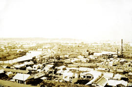
Photograph depicts a city view of Yokohama, Japan. Handwritten annotation below photograph reads, "Views in Yokohama Japan December, 1923".
Photograph depicts a garden with large shrubs and tall trees. Handwritten annotation below photograph reads, "Views of Stanley Park"
Photograph depicts a park area with fences, pedestrians, pathways and tall trees. Handwritten annotation reads "View o-Stanley Park".
Photograph depicts a view of a lake and river from a high hill. Treed hills in the background.
Photograph depicts a view of immense rolling, treed hills.
Photograph depicts treed hills in the foreground. Buildings on a field near the river in the midground. Treed hills and a body of water in the background.
Photograph depicts a lake in the foreground, treed hills in the background.
Photograph depicts a view of a lake and river from a high hill. Treed hills in the background.
Photograph depicts view of an alpine meadow, alpine trees and mountains in the background.
Photograph depicts scrub alpine trees with a layer of snow in the foreground and several mountain ranges in the distance.
Photograph depicts a view from a high mountain ridge looking down on forest, river and snowy mountain peaks in the distance.
Photograph depicts an alpine meadow in the foreground, forest, river and mountains in the distance.
Photograph depicts view of an alpine ridge with an alpine meadow in the foreground.
Photograph depicts alpine meadow in the foreground, forest, river and mountains in the distance.
Photograph depicts summit between John Brown and Kitseucla creeks.
Photograph depicts a view from the summit between John Brown and Kitseucla creeks.
Photograph depicts views from the summit between John Brown and Kitseucla creeks.
Photograph depicts a view looking down on the river with Hudson Bay mountain in the background.
Photograph depicts a view from the summit between John Brown and Kitseucla creeks.
Photograph depicts views from the summit between John Brown and Kitseucla creeks, Hudson Bay mountain.
Photograph depicts a view from the summit between John Brown and Kitseucla creeks.
Photograph depicts a few of forest in the foreground, a snowy mountain range in the distance.
Photograph depicts looking down on a snowy mountain ridge.
Photograph depicts looking up a snowy slope to a rocky peak.
Photograph depicts a view from a mountain summit looking across the valley to forested mountain slopes with snowy mountain tops.
Photograph depicts an alpine meadow with a mountain ridge in the background.
Photograph depicts looking across the water of Babine Lake toward low forested hills. [55th parallel]
Photograph depicts two men near their CF-AAM float plane on Thutade Lake in Sand Bay in front of their Consolidated Mining and Smelting Company of Canada Ltd. (CMS) camp site.
Photograph depicts three men sitting in a circle in a clear area near a sparsely forested area in front of a snowy mountain range. The location of the photograph is noted to be at Duck Creek at Copper Mountain; however, those names may no longer be in current use. Location is assumed to be approximately 55.979291, -125.208415 near what is currently named Wasi Peak.
Photograph depicts a wide view of the Omineca River with a man standing on a boat in the right corner of the image. In the background the river a forested shoreline and mountain range are visible.
Photograph depicts a view of of the tree-covered slope with Duncan Lake below.
Image depicts a view south, possibly of an abandoned grade for the BCR; possibly somewhere near Woodpecker, B.C.
Photograph depicts ditch constructed on the hill of a forested environment. Handwritten annotation on verso reads: "View showing part [of] new ditch - fully logged and braced, Germansen Placer Ltd."
Photograph depicts community buildings on shoreline, water in foreground.
Handwritten annotation on image reads: "Wrangle, Alaska."; on verso: "Fort Wrangle, Alaska Territory. visited by W.H.Collison, C.M.S. 1877. Prior to the establishment of any mission, [...? illegible] 1875 - 1876. Presbyterian. Insert this illustration of Wrangle on Page 77 as marked."
Photograph depicts a view of the community of Williams Lake, taken from the Chilcotin Road to the west.
Handwritten photo album caption below this photo reads: "Whitehorse, & Alaska Highway, from below R.C.A.F. Barracks." Photograph depicts the cityscape of Whitehorse in valley. Alaska Highway can be seen in left foreground behind road railings in mountainside.
Royal Canadian Air ForceHandwritten photo album caption below this photo reads: "Another view of Whitehorse Field from the Tower." Photograph depicts various unidentified buildings at what is believed to the Royal Canadian Air Force base in Whitehorse, YT. Small sign in foreground reads: "Taking Photographs Prohibited" (see also items 2006.20.12.1 & 2006.20.12.39). Mountains in background.
Royal Canadian Air ForcePhotograph depicts a view looking northeast towards Coal Harbour from Alberni St. (Chilco-Gilford block) with West Georgia St. in the middle distance.